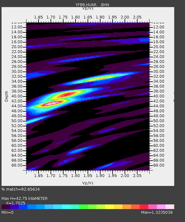
HVAR YF.HVAR - Earthquake Result Viewer

Earthquake location: Sea Of Japan
Earthquake latitude/longitude: 36.8/135.5
Earthquake time(UTC): 2000/06/06 (158) 21:16:42 GMT
Earthquake Depth: 10 km
Earthquake Magnitude: 5.7 MB, 5.3 MS, 5.9 MW, 5.8 MW
Earthquake Catalog/Contributor: WHDF/NEIC
Network: YF Midsea - Mantle Investigation of the Deep Suture between Eurasia and Africa
Station: HVAR YF.HVAR
Lat/Lon: 43.18 N/6.45 E
Elevation: 250 m
Distance: 87.9 deg
Az: 325.335 deg
Baz: 38.598 deg
Ray Param: 0.04302073
Estimated Moho Depth: 42.75 km
Estimated Crust Vp/Vs: 1.70
Assumed Crust Vp: 5.405 km/s
Estimated Crust Vs: 3.174 km/s
Estimated Crust Poisson's Ratio: 0.24
Radial Match: 92.65634 %
Radial Bump: 400
Transverse Match: 88.993935 %
Transverse Bump: 400
SOD ConfigId: 16820
Insert Time: 2010-03-08 22:37:44.353 +0000
GWidth: 2.5
Max Bumps: 400
Tol: 0.001

Signal To Noise

ChannelStoNSTALTA
YF:HVAR: :BHN:20000606T21:28:36.128027Z0.821142.4501122E-72.9837935E-7
YF:HVAR: :BHE:20000606T21:28:36.128027Z0.97229742.722554E-72.8001247E-7
YF:HVAR: :BHZ:20000606T21:28:36.128027Z0.473393354.4320726E-79.3623464E-7
Arrivals
Ps5.6 SECOND
PpPs21 SECOND
PsPs/PpSs27 SECOND