You are here: Home > Network List > KR - Kyrgyz Digital Network Stations List
> Station MNAS Manas, Kyrgyzstan > Earthquake Result Viewer
MNAS Manas, Kyrgyzstan - Earthquake Result Viewer
| Earthquake location: |
W. Caroline Islands, Micronesia |
| Earthquake latitude/longitude: |
12.1/140.2 |
| Earthquake time(UTC): |
2020/07/06 (188) 18:16:18 GMT |
| Earthquake Depth: |
12 km |
| Earthquake Magnitude: |
6.2 mww |
| Earthquake Catalog/Contributor: |
NEIC PDE/us |
|
| Network: |
KR Kyrgyz Digital Network |
| Station: |
MNAS Manas, Kyrgyzstan |
| Lat/Lon: |
42.49 N/72.50 E |
| Elevation: |
1465 m |
|
| Distance: |
65.6 deg |
| Az: |
311.245 deg |
| Baz: |
96.045 deg |
| Ray Param: |
0.058179844 |
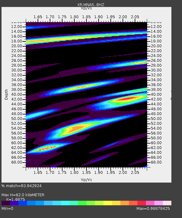
| Estimated Moho Depth: |
62.0 km |
| Estimated Crust Vp/Vs: |
1.69 |
| Assumed Crust Vp: |
6.316 km/s |
| Estimated Crust Vs: |
3.743 km/s |
| Estimated Crust Poisson's Ratio: |
0.23 |
|
| Radial Match: |
93.942924 % |
| Radial Bump: |
279 |
| Transverse Match: |
87.93561 % |
| Transverse Bump: |
376 |
| SOD ConfigId: |
21709731 |
| Insert Time: |
2020-07-20 18:28:10.407 +0000 |
| GWidth: |
2.5 |
| Max Bumps: |
400 |
| Tol: |
0.001 |
|

Signal To Noise
| Channel | StoN | STA | LTA |
| KR:MNAS: :BHZ:20200706T18:26:30.880024Z | 3.6394053 | 2.087837E-7 | 5.7367536E-8 |
| KR:MNAS: :BHN:20200706T18:26:30.880024Z | 1.2481054 | 3.5499383E-8 | 2.8442617E-8 |
| KR:MNAS: :BHE:20200706T18:26:30.880024Z | 2.6870515 | 8.438943E-8 | 3.140596E-8 |
| Arrivals |
| Ps | 7.0 SECOND |
| PpPs | 25 SECOND |
| PsPs/PpSs | 32 SECOND |


