You are here: Home > Network List > YF99 - Midsea - Mantle Investigation of the Deep Suture between Eurasia and Africa Stations List
> Station ITHO YF.ITHO > Earthquake Result Viewer
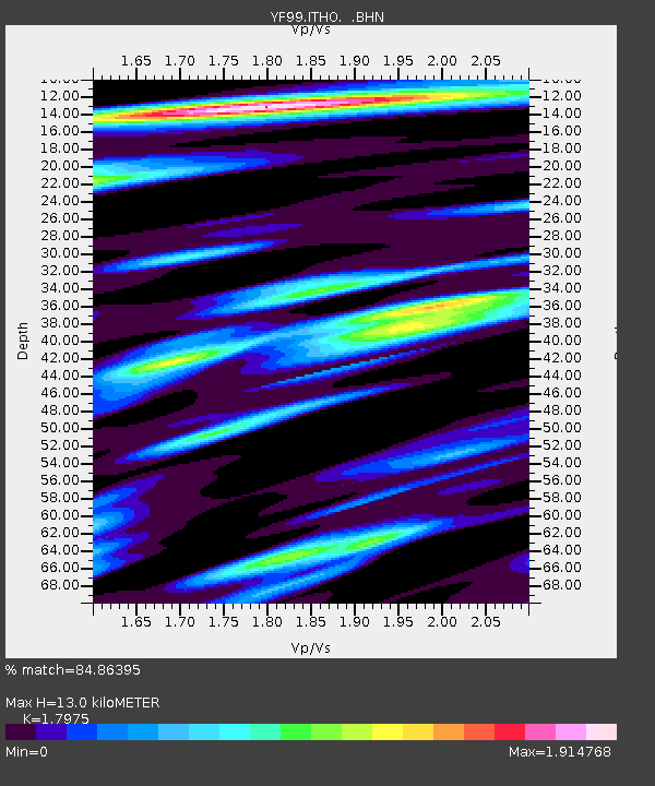
ITHO YF.ITHO - Earthquake Result Viewer
| Earthquake location: |
Kuril Islands |
| Earthquake latitude/longitude: |
44.2/148.5 |
| Earthquake time(UTC): |
2001/06/24 (175) 13:18:51 GMT |
| Earthquake Depth: |
33 km |
| Earthquake Magnitude: |
5.8 MB, 5.7 MS, 6.0 MW |
| Earthquake Catalog/Contributor: |
WHDF/NEIC |
|
| Network: |
YF Midsea - Mantle Investigation of the Deep Suture between Eurasia and Africa |
| Station: |
ITHO YF.ITHO |
| Lat/Lon: |
37.18 N/21.93 E |
| Elevation: |
400 m |
|
| Distance: |
85.7 deg |
| Az: |
319.971 deg |
| Baz: |
35.401 deg |
| Ray Param: |
0.04455565 |
| Estimated Moho Depth: |
13.0 km |
| Estimated Crust Vp/Vs: |
1.80 |
| Assumed Crust Vp: |
5.627 km/s |
| Estimated Crust Vs: |
3.13 km/s |
| Estimated Crust Poisson's Ratio: |
0.28 |
|
| Radial Match: |
84.86395 % |
| Radial Bump: |
400 |
| Transverse Match: |
78.50008 % |
| Transverse Bump: |
400 |
| SOD ConfigId: |
16820 |
| Insert Time: |
2010-03-08 22:38:35.547 +0000 |
| GWidth: |
2.5 |
| Max Bumps: |
400 |
| Tol: |
0.001 |
|

Signal To Noise
| Channel | StoN | STA | LTA |
| YF:ITHO: :BHN:20010624T13:30:55.902017Z | 3.5435202 | 1.5747115E-6 | 4.4439187E-7 |
| YF:ITHO: :BHE:20010624T13:30:55.902017Z | 1.764811 | 9.3101784E-7 | 5.2754535E-7 |
| YF:ITHO: :BHZ:20010624T13:30:55.902017Z | 9.11879 | 5.6403746E-6 | 6.185442E-7 |
| Arrivals |
| Ps | 1.9 SECOND |
| PpPs | 6.3 SECOND |
| PsPs/PpSs | 8.2 SECOND |


