
Station YF ITHO - YF.ITHO
Network: YF99 - Midsea - Mantle Investigation of the Deep Suture between Eurasia and Africa
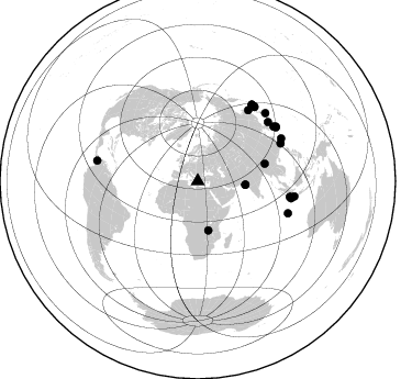
Nearby stations (2 deg radius)
| Station | Name | (Lat, Lon) | Start / End | Elevation |
| ITHO | YF.ITHO | (37.18, 21.93) | 1999-10-23 / 2001-12-31 | 0.4 km |
| Crust2 Type: | S5,continental slope, margin, transition 8 km seds. |
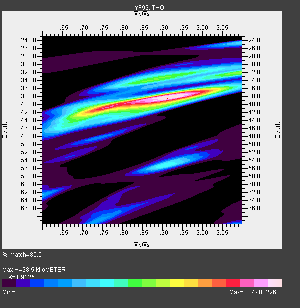
| Thickness Estimate: | 38 km |
| Thickness StdDev: | 2.1 km |
| Vp/Vs Estimate: | 1.91 |
| Vp/Vs StdDev: | 0.04 |
| Vs Estimate: | 2.942 km/s |
| Poisson's Ratio: | 0.31 |
| Peak Value: | 0.05 |
| Assumed Vp: | 5.627 km/s |
| Ps Weight: | 0.33333334 |
| PpPs Weight: | 0.33333334 |
| PsPs Weight: | 0.33333328 |
| Residual Complexity: | 0.697 |
| Nearby stations H: | 36 km +- 2.1 km |
| (2.0 deg) Vp/Vs: | 1.86 +- 0.07 |
7 with match > 90% ( 30.434782 %) and 22 with match > 80% ( 95.652176 %) out of 23.
Download stack as xyz text file.
Azimuth Distribution of Events:
Prior Results for this Station
| Study | Thickness | Vp/Vs | Vp | Vs | Poissons Ratio | Extra |
| EARS | 38 km | 1.91 | 5.627 km/s | 2.942 km/s | 0.31 | |
| Crust2.0 | 28 km | 1.82 | 5.627 km/s | 3.087 km/s | 0.28 | S5,continental slope, margin, transition 8 km seds. |
| Global Maxima | 38 km | 1.91 | 5.627 km/s | 2.942 km/s | 0.31 | amp=0.049882263 |
| Local Maxima 1 | 42 km | 1.74 | 5.627 km/s | 3.243 km/s | 0.25 | amp=0.03356716 |
| Local Maxima 2 | 37 km | 1.96 | 5.627 km/s | 2.878 km/s | 0.32 | amp=0.024471225 |
| Local Maxima 3 | 34 km | 1.83 | 5.627 km/s | 3.075 km/s | 0.29 | amp=0.01942621 |
| Local Maxima 4 | 55 km | 1.91 | 5.627 km/s | 2.938 km/s | 0.31 | amp=0.019363714 |
| Predicted Arrivals for vertical incidence (zero ray parameter) | |
| Ps | 6.24 SECOND |
| PpPs | 19.93 SECOND |
| PsPs/PpSs | 26.17 SECOND |
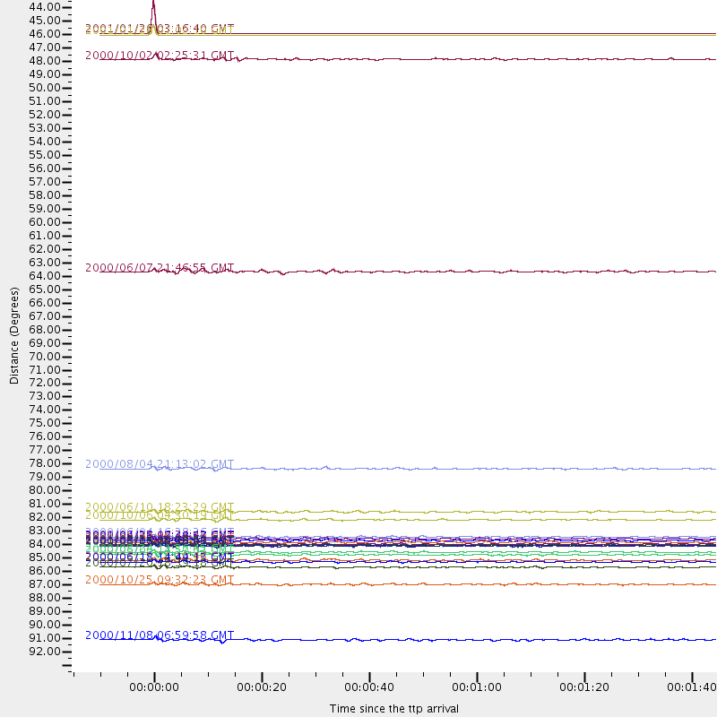
Events Processed for this Station
Download zip of receiver functions as SAC
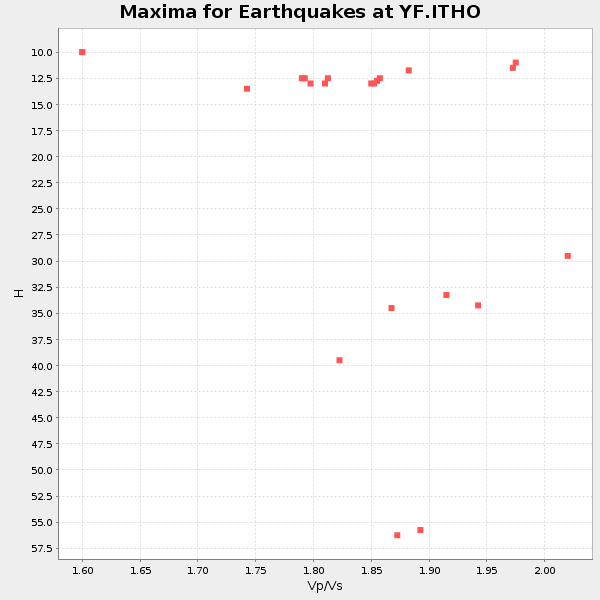
Plot maxima for each earthquake.
Events Used in the Stack
(22 events)| Radial Match | Distance | Baz | FERegion | Time | Lat/Lon | Depth | Magnitude |
| 99.9977 | 43.5 deg | 94.335 deg | Southern India | 2001/01/26 03:16:40 GMT | (23.4, 70.2) | 16 km | 6.9 MB, 8.0 MS, 7.7 MW, 7.7 ME |
| 99.98117 | 43.6 deg | 94.036 deg | Southern India | 2001/01/28 01:02:10 GMT | (23.5, 70.5) | 10 km | 5.9 MB, 5.5 MS, 5.8 MW, 5.8 MW |
| 94.74684 | 86.5 deg | 55.483 deg | Southeast Of Ryukyu Islands | 2000/06/06 14:57:02 GMT | (29.4, 131.4) | 33 km | 5.8 MB, 6.0 MS, 6.4 MW, 6.4 MW |
| 93.881905 | 79.4 deg | 35.514 deg | Sakhalin, Russia | 2000/08/04 21:13:02 GMT | (48.8, 142.2) | 10 km | 6.3 MB, 7.1 MS, 6.8 MW, 6.7 MW |
| 93.82914 | 85.0 deg | 99.695 deg | Southern Sumatra, Indonesia | 2000/06/04 16:28:26 GMT | (-4.7, 102.1) | 33 km | 6.8 MB, 8.0 MS, 7.9 MW, 7.7 MW |
| 92.52409 | 86.9 deg | 55.145 deg | Southeast Of Shikoku, Japan | 2000/06/15 11:10:46 GMT | (29.4, 132.1) | 10 km | 6.0 MB, 5.6 MS, 6.1 MW, 6.1 MW |
| 91.86983 | 85.6 deg | 35.415 deg | Kuril Islands | 2001/05/25 00:40:50 GMT | (44.3, 148.4) | 33 km | 6.1 MB, 6.7 MS, 6.7 MW, 6.6 MW |
| 89.91588 | 45.7 deg | 167.792 deg | Lake Tanganyika Region | 2000/10/02 02:25:31 GMT | (-8.0, 30.7) | 34 km | 6.1 MB, 6.7 MS, 6.5 MW, 6.2 ME |
| 89.72391 | 88.9 deg | 98.979 deg | Sunda Strait, Indonesia | 2000/10/25 09:32:23 GMT | (-6.5, 105.6) | 38 km | 6.3 MB, 6.6 MS, 6.8 MW, 6.7 ME |
| 89.1224 | 87.1 deg | 109.626 deg | South Indian Ocean | 2000/06/18 14:44:13 GMT | (-13.8, 97.5) | 10 km | 6.8 MB, 7.8 MS, 7.8 MW, 7.6 MW |
| 87.65597 | 85.2 deg | 54.277 deg | Kyushu, Japan | 2000/06/25 06:34:42 GMT | (31.2, 131.2) | 10 km | 5.8 MB, 5.7 MS, 6.2 MW, 5.9 MW |
| 87.46813 | 63.2 deg | 75.556 deg | Myanmar | 2000/06/07 21:46:55 GMT | (26.9, 97.2) | 33 km | 6.3 MB, 6.5 MS, 6.4 MW, 6.4 MW |
| 87.17348 | 87.5 deg | 44.824 deg | Near East Coast Of Honshu, Japan | 2000/07/20 18:39:18 GMT | (36.5, 141.0) | 47 km | 6.1 MB, 5.4 MS, 6.1 ME, 6.0 MW |
| 86.7375 | 83.6 deg | 49.986 deg | Western Honshu, Japan | 2000/10/06 04:30:19 GMT | (35.5, 133.1) | 10 km | 5.8 MB, 6.8 MS, 7.0 ME, 6.7 MW |
| 86.56382 | 85.7 deg | 37.115 deg | Kuril Islands | 2000/08/15 20:20:43 GMT | (43.0, 146.8) | 33 km | 5.7 MB, 5.3 MS, 5.9 MW, 5.8 MW |
| 86.13974 | 86.3 deg | 100.355 deg | Southwest Of Sumatra, Indonesia | 2000/08/24 11:36:45 GMT | (-6.0, 102.7) | 33 km | 5.7 MB, 5.9 MS, 6.0 MW, 5.8 MW |
| 85.475845 | 85.7 deg | 99.613 deg | Southern Sumatra, Indonesia | 2000/06/06 09:58:06 GMT | (-5.1, 102.7) | 33 km | 5.8 MB, 6.1 MS, 6.2 MW, 6.1 MW |
| 85.38954 | 85.3 deg | 37.542 deg | Hokkaido, Japan Region | 2001/04/26 17:48:57 GMT | (43.1, 145.9) | 86 km | 5.7 MB, 6.0 MW, 6.0 MW |
| 84.86395 | 85.7 deg | 35.401 deg | Kuril Islands | 2001/06/24 13:18:51 GMT | (44.2, 148.5) | 33 km | 5.8 MB, 5.7 MS, 6.0 MW |
| 84.58597 | 82.9 deg | 65.59 deg | Taiwan | 2000/06/10 18:23:29 GMT | (23.8, 121.2) | 33 km | 6.2 MB, 6.2 MS, 6.4 MW, 6.3 MW |
| 82.5175 | 85.4 deg | 63.052 deg | Southwestern Ryukyu Isl., Japan | 2001/02/08 05:41:39 GMT | (24.3, 125.1) | 16 km | 5.5 MB, 5.5 MS, 5.8 MW, 5.8 MW |
| 80.29996 | 93.5 deg | 281.469 deg | Panama-Colombia Border Region | 2000/11/08 06:59:58 GMT | (7.0, -77.8) | 17 km | 6.0 MB, 6.4 MS, 6.5 MW, 6.2 ML |
Losers
(1 events)| Radial Match | Distance | Baz | FERegion | Time | Lat/Lon | Depth | Magnitude | Reason |
| 81.414085 | 85.6 deg | 99.495 deg | Southern Sumatra, Indonesia | 2000/06/05 06:34:11 GMT | (-4.9, 102.7) | 33 km | 5.4 MB, 5.5 MS, 5.8 MW |
