You are here: Home > Network List > YF99 - Midsea - Mantle Investigation of the Deep Suture between Eurasia and Africa Stations List
> Station KOUM YF.KOUM > Earthquake Result Viewer
KOUM YF.KOUM - Earthquake Result Viewer
| Earthquake location: |
Luzon, Philippines |
| Earthquake latitude/longitude: |
14.0/120.5 |
| Earthquake time(UTC): |
2000/06/19 (171) 09:34:57 GMT |
| Earthquake Depth: |
115 km |
| Earthquake Magnitude: |
5.7 MB, 5.7 MW, 5.6 MW |
| Earthquake Catalog/Contributor: |
WHDF/NEIC |
|
| Network: |
YF Midsea - Mantle Investigation of the Deep Suture between Eurasia and Africa |
| Station: |
KOUM YF.KOUM |
| Lat/Lon: |
37.70 N/26.84 E |
| Elevation: |
340 m |
|
| Distance: |
84.4 deg |
| Az: |
307.32 deg |
| Baz: |
76.703 deg |
| Ray Param: |
0.04522768 |
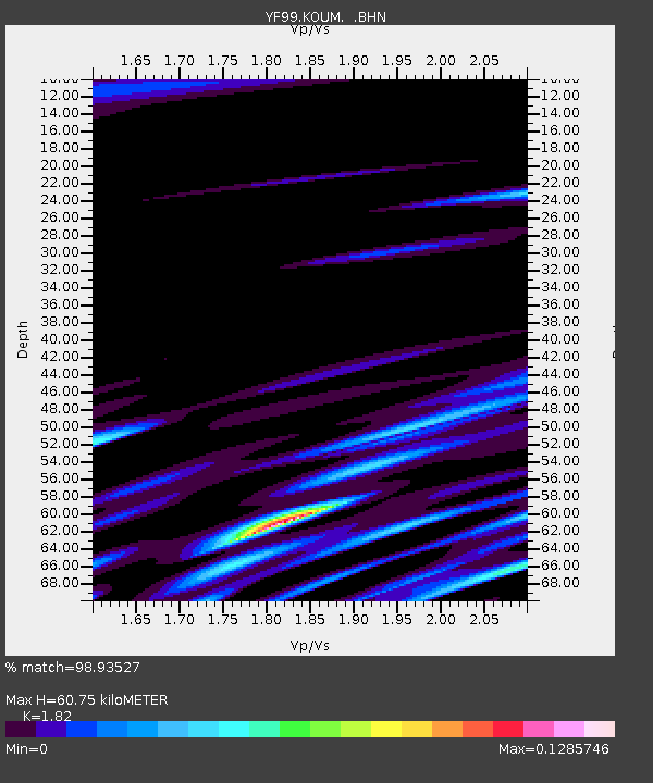
| Estimated Moho Depth: |
60.75 km |
| Estimated Crust Vp/Vs: |
1.82 |
| Assumed Crust Vp: |
5.989 km/s |
| Estimated Crust Vs: |
3.291 km/s |
| Estimated Crust Poisson's Ratio: |
0.28 |
|
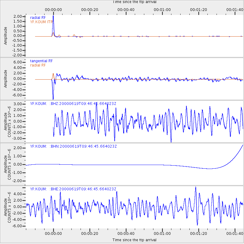
| Radial Match: |
98.93527 % |
| Radial Bump: |
114 |
| Transverse Match: |
67.01372 % |
| Transverse Bump: |
400 |
| SOD ConfigId: |
16820 |
| Insert Time: |
2010-03-08 22:38:47.516 +0000 |
| GWidth: |
2.5 |
| Max Bumps: |
400 |
| Tol: |
0.001 |
|
Signal To Noise
| Channel | StoN | STA | LTA |
| YF:KOUM: :BHN:20000619T09:46:45.664023Z | 0.93307877 | 3.9038937E-7 | 4.1838845E-7 |
| YF:KOUM: :BHE:20000619T09:46:45.664023Z | 1.2953713 | 2.224496E-6 | 1.7172653E-6 |
| YF:KOUM: :BHZ:20000619T09:46:45.664023Z | 1.301259 | 1.5601668E-6 | 1.1989671E-6 |
| Arrivals |
| Ps | 8.5 SECOND |
| PpPs | 28 SECOND |
| PsPs/PpSs | 37 SECOND |


