
Station YF KOUM - YF.KOUM
Network: YF99 - Midsea - Mantle Investigation of the Deep Suture between Eurasia and Africa
Nearby stations (2 deg radius)
| Station | Name | (Lat, Lon) | Start / End | Elevation |
| KOUM | YF.KOUM | (37.70, 26.84) | 1999-10-28 / 2499-01-01 | 340 m |
| Crust2 Type: | C4,continental shelf, 3.5 km seds. |
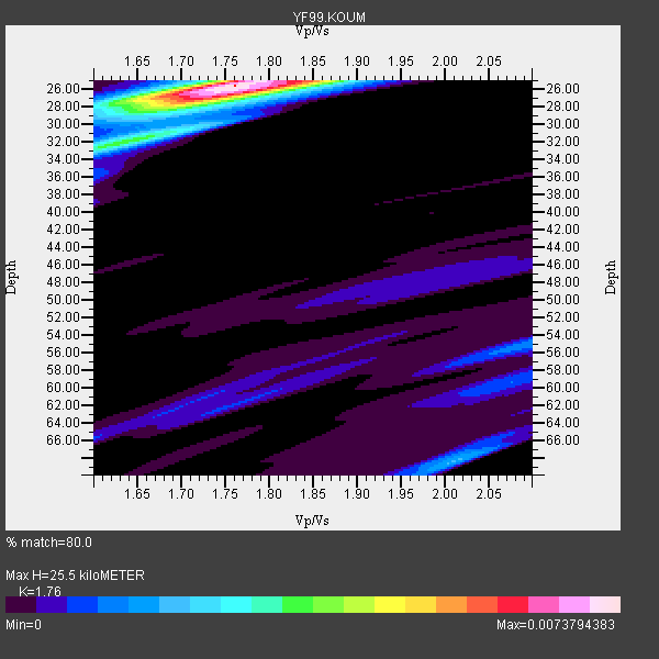
| Thickness Estimate: | 26 km |
| Thickness StdDev: | 1.8 km |
| Vp/Vs Estimate: | 1.76 |
| Vp/Vs StdDev: | 0.04 |
| Vs Estimate: | 3.403 km/s |
| Poisson's Ratio: | 0.26 |
| Peak Value: | 0.01 |
| Assumed Vp: | 5.989 km/s |
| Ps Weight: | 0.33333334 |
| PpPs Weight: | 0.33333334 |
| PsPs Weight: | 0.33333328 |
| Residual Complexity: | 0.448 |
| Nearby stations H: | +- |
| (2.0 deg) Vp/Vs: | +- |
20 with match > 90% ( 76.92308 %) and 26 with match > 80% ( 100.0 %) out of 26.
Download stack as xyz text file.
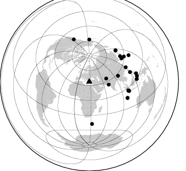
Azimuth Distribution of Events:
Prior Results for this Station
| Study | Thickness | Vp/Vs | Vp | Vs | Poissons Ratio | Extra |
| EARS | 26 km | 1.76 | 5.989 km/s | 3.403 km/s | 0.26 | |
| Crust2.0 | 32 km | 1.81 | 5.989 km/s | 3.317 km/s | 0.28 | C4,continental shelf, 3.5 km seds. |
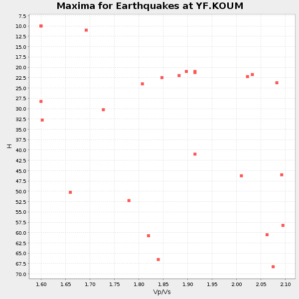
| Global Maxima | 26 km | 1.76 | 5.989 km/s | 3.403 km/s | 0.26 | amp=0.0073794383 |
| Local Maxima 1 | 32 km | 1.64 | 5.989 km/s | 3.646 km/s | 0.21 | amp=0.0033176844 |
| Local Maxima 2 | 27 km | 1.71 | 5.989 km/s | 3.497 km/s | 0.24 | amp=0.0026546698 |
| Local Maxima 3 | 68 km | 2.01 | 5.989 km/s | 2.98 km/s | 0.34 | amp=0.0016274096 |
| Local Maxima 4 | 55 km | 2.10 | 5.989 km/s | 2.855 km/s | 0.35 | amp=0.0013968942 |
| Predicted Arrivals for vertical incidence (zero ray parameter) | |
| Ps | 3.24 SECOND |
| PpPs | 11.75 SECOND |
| PsPs/PpSs | 14.99 SECOND |
Events Processed for this Station
Download zip of receiver functions as SAC
Plot maxima for each earthquake.
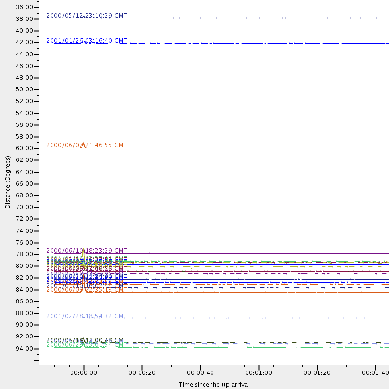
Events Used in the Stack
(26 events)| Radial Match | Distance | Baz | FERegion | Time | Lat/Lon | Depth | Magnitude |
| 99.999695 | 81.3 deg | 102.756 deg | Southern Sumatra, Indonesia | 2000/06/04 16:39:45 GMT | (-4.6, 102.1) | 33 km | 6.7 MB |
| 99.99626 | 81.3 deg | 102.824 deg | Southern Sumatra, Indonesia | 2000/06/04 16:28:26 GMT | (-4.7, 102.1) | 33 km | 6.8 MB, 8.0 MS, 7.9 MW, 7.7 MW |
| 99.995804 | 83.6 deg | 112.756 deg | South Indian Ocean | 2000/06/18 14:44:13 GMT | (-13.8, 97.5) | 10 km | 6.8 MB, 7.8 MS, 7.8 MW, 7.6 MW |
| 99.98757 | 59.2 deg | 78.326 deg | Myanmar | 2000/06/07 21:46:55 GMT | (26.9, 97.2) | 33 km | 6.3 MB, 6.5 MS, 6.4 MW, 6.4 MW |
| 99.98411 | 81.1 deg | 102.854 deg | Southern Sumatra, Indonesia | 2000/06/07 23:45:26 GMT | (-4.6, 101.9) | 33 km | 6.1 MB, 6.7 MS, 6.7 MW, 6.5 MW |
| 99.95634 | 79.1 deg | 68.399 deg | Taiwan | 2000/06/10 18:23:29 GMT | (23.8, 121.2) | 33 km | 6.2 MB, 6.2 MS, 6.4 MW, 6.3 MW |
| 99.88066 | 82.0 deg | 102.725 deg | Southern Sumatra, Indonesia | 2000/06/06 09:58:06 GMT | (-5.1, 102.7) | 33 km | 5.8 MB, 6.1 MS, 6.2 MW, 6.1 MW |
| 99.77981 | 83.9 deg | 112.904 deg | South Indian Ocean | 2000/06/20 11:34:00 GMT | (-14.1, 97.6) | 10 km | 5.6 MB, 5.6 MS, 6.1 MW, 5.8 MW |
| 99.62758 | 95.8 deg | 79.75 deg | Talaud Islands, Indonesia | 2000/06/14 17:00:48 GMT | (4.5, 127.7) | 90 km | 6.1 MB, 5.6 MS, 6.4 MW, 6.3 MW |
| 99.43598 | 82.5 deg | 103.005 deg | Southern Sumatra, Indonesia | 2000/06/05 03:00:26 GMT | (-5.6, 102.9) | 33 km | 5.5 MB, 5.5 MS, 5.8 MW, 5.8 MW |
| 98.93527 | 84.4 deg | 76.703 deg | Luzon, Philippines | 2000/06/19 09:34:57 GMT | (14.0, 120.5) | 115 km | 5.7 MB, 5.7 MW, 5.6 MW |
| 96.66859 | 85.6 deg | 0.027 deg | Kodiak Island Region, Alaska | 2001/01/10 16:02:44 GMT | (57.1, -153.2) | 33 km | 6.2 MB, 6.8 MS, 7.1 MW, 6.8 ML |
| 96.38981 | 81.6 deg | 102.49 deg | Southern Sumatra, Indonesia | 2001/02/13 19:28:30 GMT | (-4.7, 102.6) | 36 km | 6.2 MB, 7.2 MS, 7.4 MW, 7.0 ME |
| 96.29146 | 96.7 deg | 83.216 deg | Northern Molucca Sea | 2000/06/23 05:01:54 GMT | (1.3, 126.3) | 65 km | 6.0 MB, 5.1 MS, 5.8 MW, 5.8 MW |
| 96.25078 | 95.9 deg | 56.105 deg | Volcano Islands, Japan Region | 2000/03/28 11:00:22 GMT | (22.3, 143.7) | 126 km | 6.8 MB, 7.6 MS, 7.6 MW, 7.6 MW |
| 95.64111 | 39.6 deg | 98.387 deg | Southern India | 2001/01/26 03:16:40 GMT | (23.4, 70.2) | 16 km | 6.9 MB, 8.0 MS, 7.7 MW, 7.7 ME |
| 94.78428 | 86.4 deg | 53.949 deg | Southeast Of Honshu, Japan | 2000/06/09 22:35:13 GMT | (30.5, 137.7) | 473 km | 5.4 MB, 5.9 MW, 5.8 MW |
| 94.621574 | 80.7 deg | 54.067 deg | Western Honshu, Japan | 2001/03/24 06:27:53 GMT | (34.1, 132.5) | 50 km | 6.4 MB, 6.5 MS, 6.8 MW, 6.4 ME |
| 93.44775 | 82.9 deg | 39.775 deg | Kuril Islands | 2000/01/28 14:21:07 GMT | (43.0, 146.8) | 61 km | 6.7 MB, 6.6 MS, 6.8 MW, 6.8 ME |
| 91.3994 | 34.9 deg | 79.169 deg | Hindu Kush Region, Afghanistan | 2000/05/12 23:10:29 GMT | (36.0, 70.7) | 108 km | 6.2 MB, 6.3 MW, 6.3 MW |
| 85.40186 | 84.9 deg | 176.223 deg | Prince Edward Islands Region | 2001/02/18 13:04:53 GMT | (-47.5, 32.4) | 10 km | 5.5 MB, 5.7 MS, 6.1 MW, 6.0 MW |
| 84.69125 | 96.0 deg | 86.759 deg | Sulawesi, Indonesia | 2000/05/04 04:21:16 GMT | (-1.1, 123.6) | 26 km | 6.7 MB, 7.5 MS, 7.6 MW, 7.5 ME |
| 82.73927 | 91.2 deg | 339.767 deg | Washington | 2001/02/28 18:54:32 GMT | (47.1, -122.7) | 52 km | 6.5 MB, 6.6 MS, 6.8 MW, 6.7 ME |
| 82.390366 | 80.5 deg | 102.444 deg | Southern Sumatra, Indonesia | 2001/01/16 13:25:01 GMT | (-4.0, 101.7) | 33 km | 6.0 MB |
| 82.038345 | 80.8 deg | 50.379 deg | Sea Of Japan | 2000/06/06 21:16:42 GMT | (36.8, 135.5) | 10 km | 5.7 MB, 5.3 MS, 5.9 MW, 5.8 MW |
| 81.7145 | 82.4 deg | 40.224 deg | Hokkaido, Japan Region | 2001/04/26 17:48:57 GMT | (43.1, 145.9) | 86 km | 5.7 MB, 6.0 MW, 6.0 MW |
Losers
(0 events)| Radial Match | Distance | Baz | FERegion | Time | Lat/Lon | Depth | Magnitude | Reason |
