You are here: Home > Network List > YF99 - Midsea - Mantle Investigation of the Deep Suture between Eurasia and Africa Stations List
> Station KOUM YF.KOUM > Earthquake Result Viewer
KOUM YF.KOUM - Earthquake Result Viewer
| Earthquake location: |
Southeast Of Honshu, Japan |
| Earthquake latitude/longitude: |
30.5/137.7 |
| Earthquake time(UTC): |
2000/06/09 (161) 22:35:13 GMT |
| Earthquake Depth: |
473 km |
| Earthquake Magnitude: |
5.4 MB, 5.9 MW, 5.8 MW |
| Earthquake Catalog/Contributor: |
WHDF/NEIC |
|
| Network: |
YF Midsea - Mantle Investigation of the Deep Suture between Eurasia and Africa |
| Station: |
KOUM YF.KOUM |
| Lat/Lon: |
37.70 N/26.84 E |
| Elevation: |
340 m |
|
| Distance: |
86.4 deg |
| Az: |
312.033 deg |
| Baz: |
53.949 deg |
| Ray Param: |
0.042825323 |
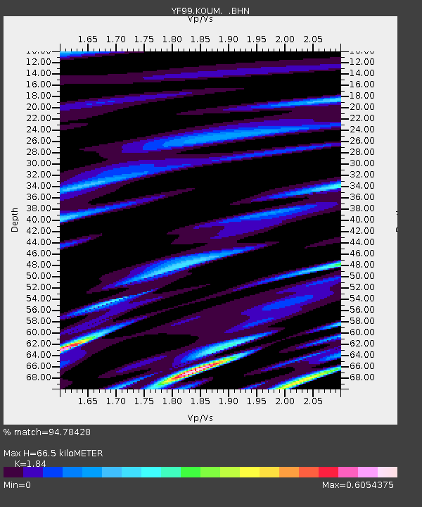
| Estimated Moho Depth: |
66.5 km |
| Estimated Crust Vp/Vs: |
1.84 |
| Assumed Crust Vp: |
5.989 km/s |
| Estimated Crust Vs: |
3.255 km/s |
| Estimated Crust Poisson's Ratio: |
0.29 |
|
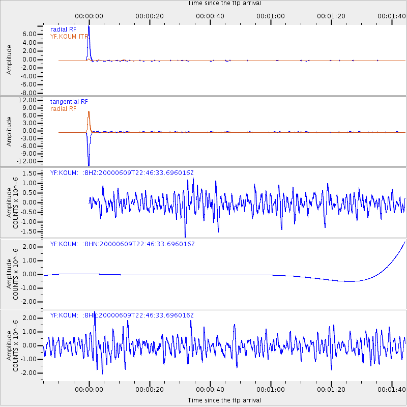
| Radial Match: |
94.78428 % |
| Radial Bump: |
135 |
| Transverse Match: |
91.28953 % |
| Transverse Bump: |
169 |
| SOD ConfigId: |
16820 |
| Insert Time: |
2010-03-08 22:38:49.536 +0000 |
| GWidth: |
2.5 |
| Max Bumps: |
400 |
| Tol: |
0.001 |
|
Signal To Noise
| Channel | StoN | STA | LTA |
| YF:KOUM: :BHN:20000609T22:46:33.696016Z | 0.93330073 | 3.9048226E-7 | 4.1838845E-7 |
| YF:KOUM: :BHE:20000609T22:46:33.696016Z | 2.2590477 | 9.88678E-7 | 4.3765255E-7 |
| YF:KOUM: :BHZ:20000609T22:46:33.696016Z | 2.2106376 | 7.0357714E-7 | 3.182689E-7 |
| Arrivals |
| Ps | 9.5 SECOND |
| PpPs | 31 SECOND |
| PsPs/PpSs | 40 SECOND |


