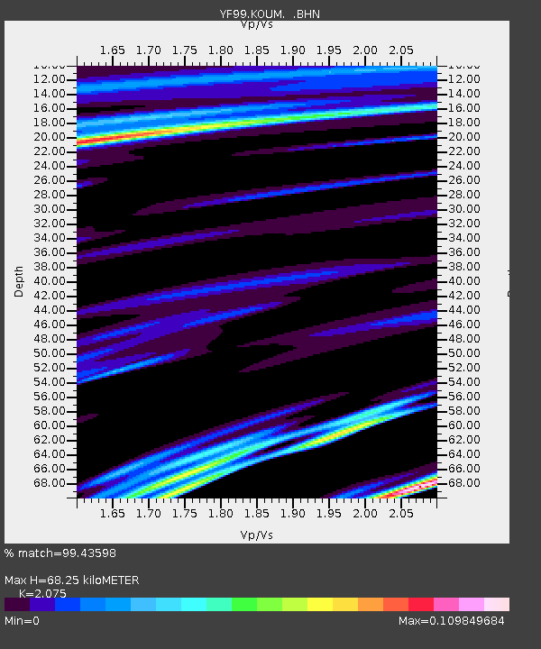
KOUM YF.KOUM - Earthquake Result Viewer
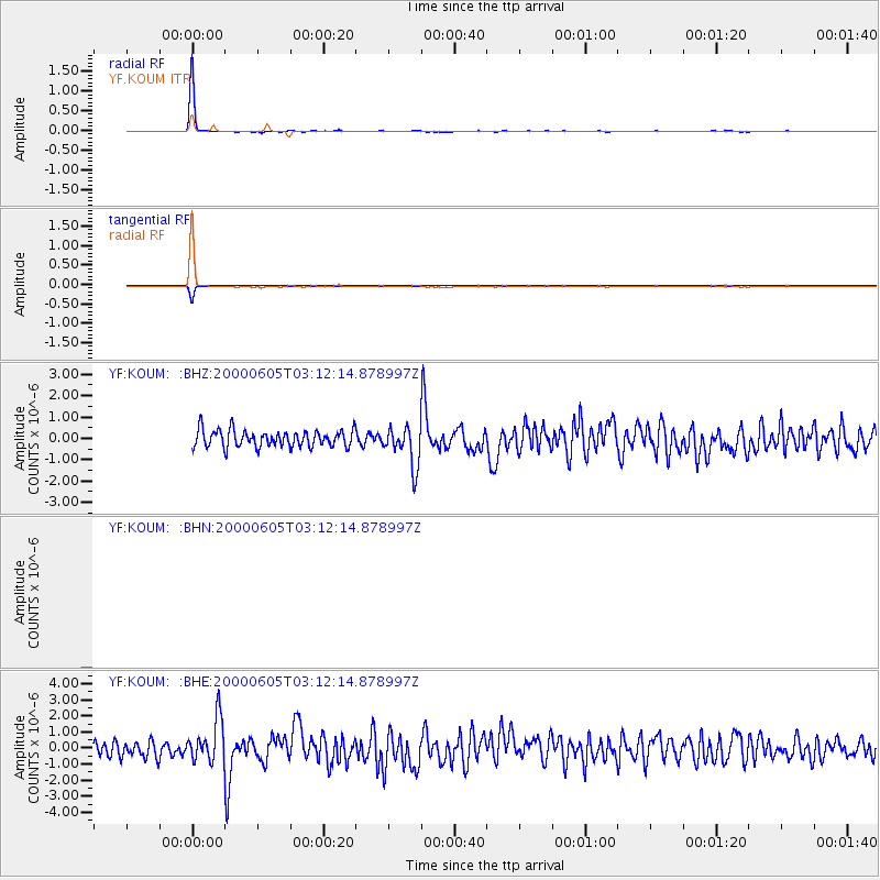
Earthquake location: Southern Sumatra, Indonesia
Earthquake latitude/longitude: -5.6/102.9
Earthquake time(UTC): 2000/06/05 (157) 03:00:26 GMT
Earthquake Depth: 33 km
Earthquake Magnitude: 5.5 MB, 5.5 MS, 5.8 MW, 5.8 MW
Earthquake Catalog/Contributor: WHDF/NEIC
Network: YF Midsea - Mantle Investigation of the Deep Suture between Eurasia and Africa
Station: KOUM YF.KOUM
Lat/Lon: 37.70 N/26.84 E
Elevation: 340 m
Distance: 82.5 deg
Az: 309.061 deg
Baz: 103.005 deg
Ray Param: 0.04682927
Estimated Moho Depth: 68.25 km
Estimated Crust Vp/Vs: 2.08
Assumed Crust Vp: 5.989 km/s
Estimated Crust Vs: 2.886 km/s
Estimated Crust Poisson's Ratio: 0.35
Radial Match: 99.43598 %
Radial Bump: 85
Transverse Match: 99.43599 %
Transverse Bump: 85
SOD ConfigId: 3753
Insert Time: 2010-03-08 22:38:52.803 +0000
GWidth: 2.5
Max Bumps: 400
Tol: 0.001

Signal To Noise

ChannelStoNSTALTA
$trig.getChannelId()$trig.getValue()$trig.getSTA()$trig.getLTA()
YF:KOUM: :BHE:20000605T03:12:14.878997Z2.4643631.3826242E-65.610473E-7
YF:KOUM: :BHZ:20000605T03:12:14.878997Z2.40077529.404205E-73.9171533E-7
Arrivals
Ps12 SECOND
PpPs34 SECOND
PsPs/PpSs47 SECOND