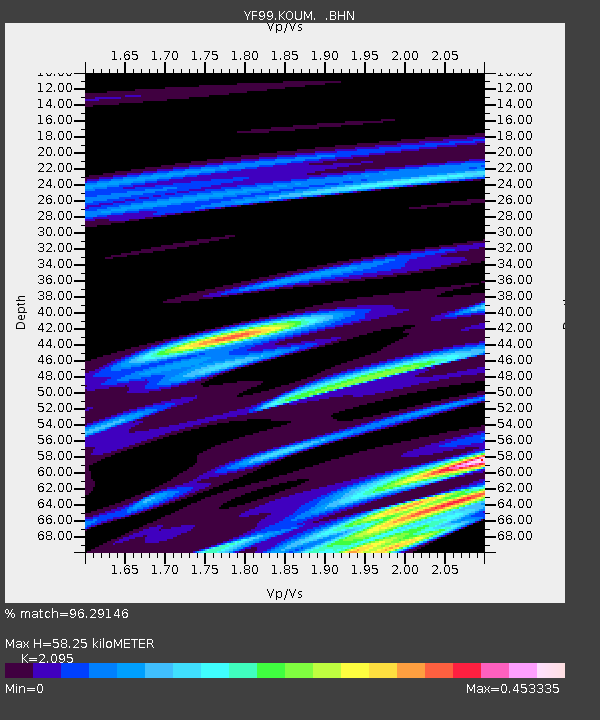
KOUM YF.KOUM - Earthquake Result Viewer
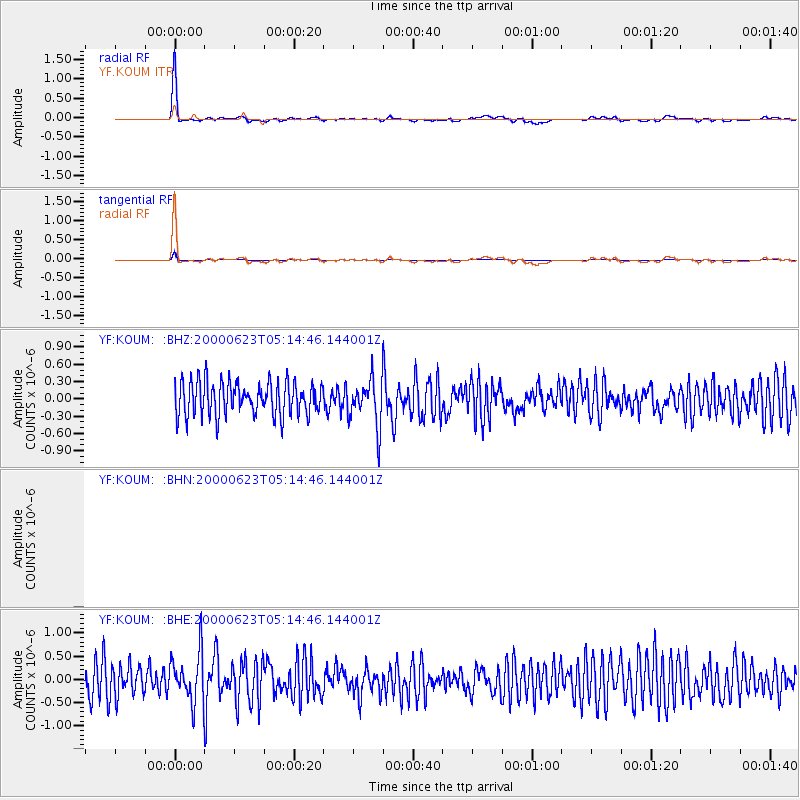
Earthquake location: Northern Molucca Sea
Earthquake latitude/longitude: 1.3/126.3
Earthquake time(UTC): 2000/06/23 (175) 05:01:54 GMT
Earthquake Depth: 65 km
Earthquake Magnitude: 6.0 MB, 5.1 MS, 5.8 MW, 5.8 MW
Earthquake Catalog/Contributor: WHDF/NEIC
Network: YF Midsea - Mantle Investigation of the Deep Suture between Eurasia and Africa
Station: KOUM YF.KOUM
Lat/Lon: 37.70 N/26.84 E
Elevation: 340 m
Distance: 96.7 deg
Az: 308.019 deg
Baz: 83.216 deg
Ray Param: 0.04039516
Estimated Moho Depth: 58.25 km
Estimated Crust Vp/Vs: 2.10
Assumed Crust Vp: 5.989 km/s
Estimated Crust Vs: 2.859 km/s
Estimated Crust Poisson's Ratio: 0.35
Radial Match: 96.29146 %
Radial Bump: 314
Transverse Match: 96.29146 %
Transverse Bump: 314
SOD ConfigId: 3744
Insert Time: 2010-03-08 22:38:54.542 +0000
GWidth: 2.5
Max Bumps: 400
Tol: 0.001

Signal To Noise

ChannelStoNSTALTA
$trig.getChannelId()$trig.getValue()$trig.getSTA()$trig.getLTA()
YF:KOUM: :BHE:20000623T05:14:46.144001Z1.38154485.455916E-73.949142E-7
YF:KOUM: :BHZ:20000623T05:14:46.144001Z1.44352774.1149787E-72.8506403E-7
Arrivals
Ps11 SECOND
PpPs30 SECOND
PsPs/PpSs40 SECOND