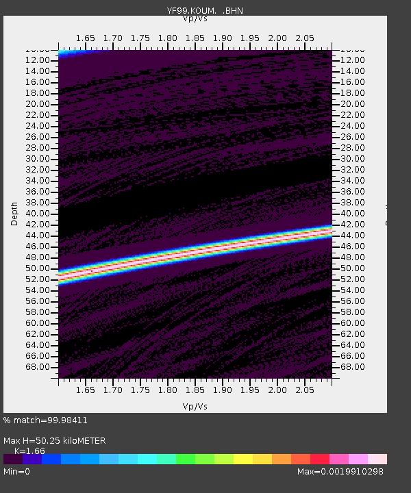
KOUM YF.KOUM - Earthquake Result Viewer
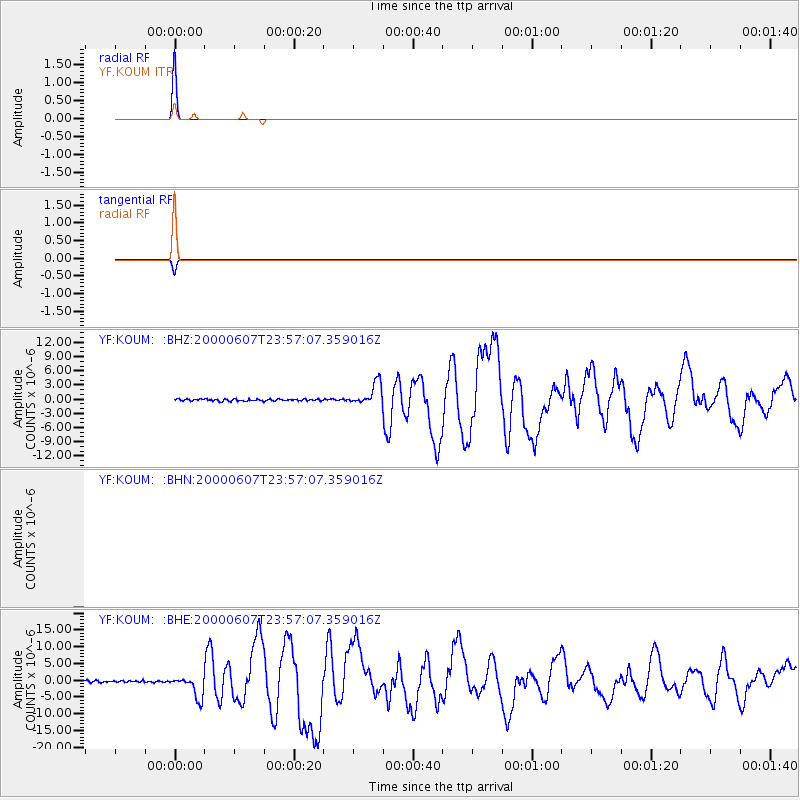
Earthquake location: Southern Sumatra, Indonesia
Earthquake latitude/longitude: -4.6/101.9
Earthquake time(UTC): 2000/06/07 (159) 23:45:26 GMT
Earthquake Depth: 33 km
Earthquake Magnitude: 6.1 MB, 6.7 MS, 6.7 MW, 6.5 MW
Earthquake Catalog/Contributor: WHDF/NEIC
Network: YF Midsea - Mantle Investigation of the Deep Suture between Eurasia and Africa
Station: KOUM YF.KOUM
Lat/Lon: 37.70 N/26.84 E
Elevation: 340 m
Distance: 81.1 deg
Az: 309.126 deg
Baz: 102.854 deg
Ray Param: 0.047794167
Estimated Moho Depth: 50.25 km
Estimated Crust Vp/Vs: 1.66
Assumed Crust Vp: 5.989 km/s
Estimated Crust Vs: 3.608 km/s
Estimated Crust Poisson's Ratio: 0.22
Radial Match: 99.98411 %
Radial Bump: 2
Transverse Match: 99.98411 %
Transverse Bump: 2
SOD ConfigId: 3744
Insert Time: 2010-03-08 22:39:05.410 +0000
GWidth: 2.5
Max Bumps: 400
Tol: 0.001

Signal To Noise

ChannelStoNSTALTA
$trig.getChannelId()$trig.getValue()$trig.getSTA()$trig.getLTA()
YF:KOUM: :BHE:20000607T23:57:07.359016Z12.6810983.2503262E-62.563127E-7
YF:KOUM: :BHZ:20000607T23:57:07.359016Z12.1903942.3243454E-61.9067024E-7
Arrivals
Ps5.7 SECOND
PpPs22 SECOND
PsPs/PpSs27 SECOND