You are here: Home > Network List > YF99 - Midsea - Mantle Investigation of the Deep Suture between Eurasia and Africa Stations List
> Station KOUM YF.KOUM > Earthquake Result Viewer
KOUM YF.KOUM - Earthquake Result Viewer
| Earthquake location: |
Southern Sumatra, Indonesia |
| Earthquake latitude/longitude: |
-4.6/102.1 |
| Earthquake time(UTC): |
2000/06/04 (156) 16:39:45 GMT |
| Earthquake Depth: |
33 km |
| Earthquake Magnitude: |
6.7 MB |
| Earthquake Catalog/Contributor: |
WHDF/NEIC |
|
| Network: |
YF Midsea - Mantle Investigation of the Deep Suture between Eurasia and Africa |
| Station: |
KOUM YF.KOUM |
| Lat/Lon: |
37.70 N/26.84 E |
| Elevation: |
340 m |
|
| Distance: |
81.3 deg |
| Az: |
309.095 deg |
| Baz: |
102.756 deg |
| Ray Param: |
0.047672246 |
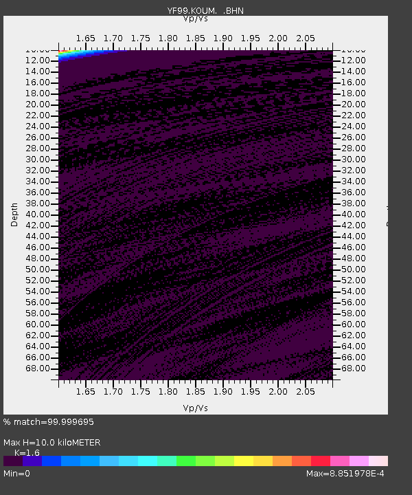
| Estimated Moho Depth: |
10.0 km |
| Estimated Crust Vp/Vs: |
1.60 |
| Assumed Crust Vp: |
5.989 km/s |
| Estimated Crust Vs: |
3.743 km/s |
| Estimated Crust Poisson's Ratio: |
0.18 |
|
| Radial Match: |
99.999695 % |
| Radial Bump: |
2 |
| Transverse Match: |
99.9997 % |
| Transverse Bump: |
2 |
| SOD ConfigId: |
3744 |
| Insert Time: |
2010-03-08 22:39:13.928 +0000 |
| GWidth: |
2.5 |
| Max Bumps: |
400 |
| Tol: |
0.001 |
|
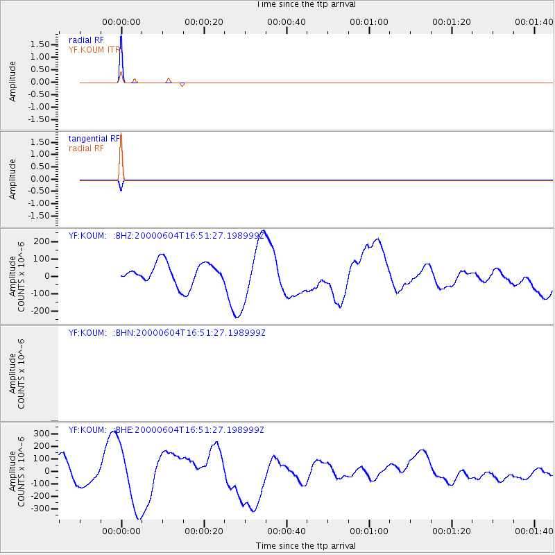
Signal To Noise
| Channel | StoN | STA | LTA |
| $trig.getChannelId() | $trig.getValue() | $trig.getSTA() | $trig.getLTA() |
| YF:KOUM: :BHE:20000604T16:51:27.198999Z | 2.7752213 | 2.4301071E-4 | 8.756444E-5 |
| YF:KOUM: :BHZ:20000604T16:51:27.198999Z | 2.7756436 | 1.7254984E-4 | 6.216571E-5 |
| Arrivals |
| Ps | 1.0 SECOND |
| PpPs | 4.2 SECOND |
| PsPs/PpSs | 5.3 SECOND |


