You are here: Home > Network List > YF99 - Midsea - Mantle Investigation of the Deep Suture between Eurasia and Africa Stations List
> Station KOUM YF.KOUM > Earthquake Result Viewer
KOUM YF.KOUM - Earthquake Result Viewer
| Earthquake location: |
Hindu Kush Region, Afghanistan |
| Earthquake latitude/longitude: |
36.0/70.7 |
| Earthquake time(UTC): |
2000/05/12 (133) 23:10:29 GMT |
| Earthquake Depth: |
108 km |
| Earthquake Magnitude: |
6.2 MB, 6.3 MW, 6.3 MW |
| Earthquake Catalog/Contributor: |
WHDF/NEIC |
|
| Network: |
YF Midsea - Mantle Investigation of the Deep Suture between Eurasia and Africa |
| Station: |
KOUM YF.KOUM |
| Lat/Lon: |
37.70 N/26.84 E |
| Elevation: |
340 m |
|
| Distance: |
34.9 deg |
| Az: |
286.175 deg |
| Baz: |
79.169 deg |
| Ray Param: |
0.07717168 |
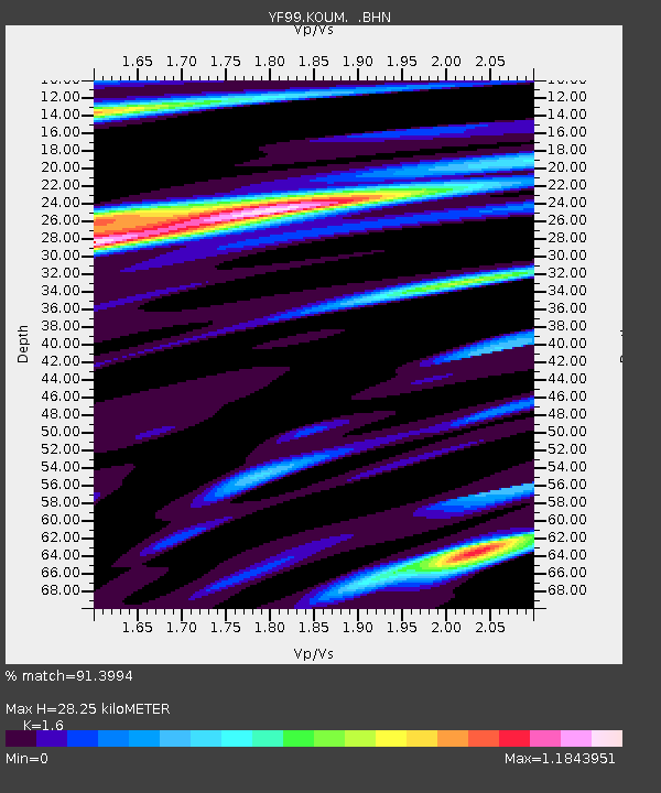
| Estimated Moho Depth: |
28.25 km |
| Estimated Crust Vp/Vs: |
1.60 |
| Assumed Crust Vp: |
5.989 km/s |
| Estimated Crust Vs: |
3.743 km/s |
| Estimated Crust Poisson's Ratio: |
0.18 |
|
| Radial Match: |
91.3994 % |
| Radial Bump: |
400 |
| Transverse Match: |
81.907196 % |
| Transverse Bump: |
400 |
| SOD ConfigId: |
3744 |
| Insert Time: |
2010-03-08 22:39:16.846 +0000 |
| GWidth: |
2.5 |
| Max Bumps: |
400 |
| Tol: |
0.001 |
|
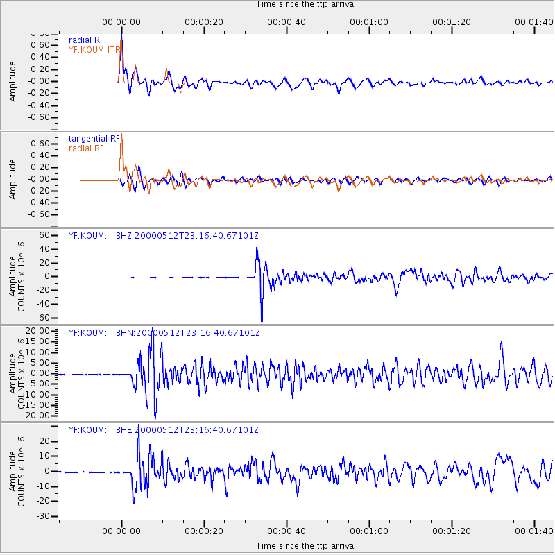
Signal To Noise
| Channel | StoN | STA | LTA |
| YF:KOUM: :BHN:20000512T23:16:40.67101Z | 29.218082 | 3.7860823E-6 | 1.295801E-7 |
| YF:KOUM: :BHE:20000512T23:16:40.67101Z | 50.63682 | 1.0040331E-5 | 1.9828123E-7 |
| YF:KOUM: :BHZ:20000512T23:16:40.67101Z | 76.318085 | 2.1731461E-5 | 2.847485E-7 |
| Arrivals |
| Ps | 3.0 SECOND |
| PpPs | 11 SECOND |
| PsPs/PpSs | 14 SECOND |


