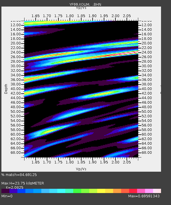
KOUM YF.KOUM - Earthquake Result Viewer
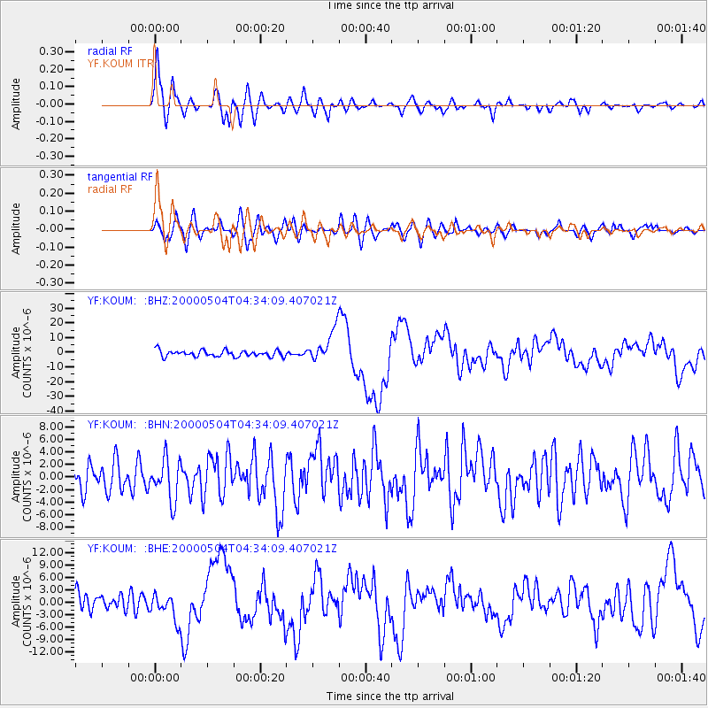
Earthquake location: Sulawesi, Indonesia
Earthquake latitude/longitude: -1.1/123.6
Earthquake time(UTC): 2000/05/04 (125) 04:21:16 GMT
Earthquake Depth: 26 km
Earthquake Magnitude: 6.7 MB, 7.5 MS, 7.6 MW, 7.5 ME
Earthquake Catalog/Contributor: WHDF/NEIC
Network: YF Midsea - Mantle Investigation of the Deep Suture between Eurasia and Africa
Station: KOUM YF.KOUM
Lat/Lon: 37.70 N/26.84 E
Elevation: 340 m
Distance: 96.0 deg
Az: 307.624 deg
Baz: 86.759 deg
Ray Param: 0.04062111
Estimated Moho Depth: 23.75 km
Estimated Crust Vp/Vs: 2.08
Assumed Crust Vp: 5.989 km/s
Estimated Crust Vs: 2.876 km/s
Estimated Crust Poisson's Ratio: 0.35
Radial Match: 84.69125 %
Radial Bump: 400
Transverse Match: 61.89846 %
Transverse Bump: 400
SOD ConfigId: 3744
Insert Time: 2010-03-08 22:39:18.618 +0000
GWidth: 2.5
Max Bumps: 400
Tol: 0.001

Signal To Noise

ChannelStoNSTALTA
YF:KOUM: :BHN:20000504T04:34:09.407021Z1.49521363.3047436E-62.210215E-6
YF:KOUM: :BHE:20000504T04:34:09.407021Z1.15267873.2349478E-62.806461E-6
YF:KOUM: :BHZ:20000504T04:34:09.407021Z5.3108231.1289721E-52.1257952E-6
Arrivals
Ps4.4 SECOND
PpPs12 SECOND
PsPs/PpSs16 SECOND