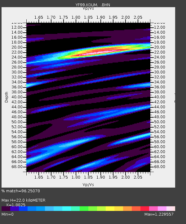
KOUM YF.KOUM - Earthquake Result Viewer
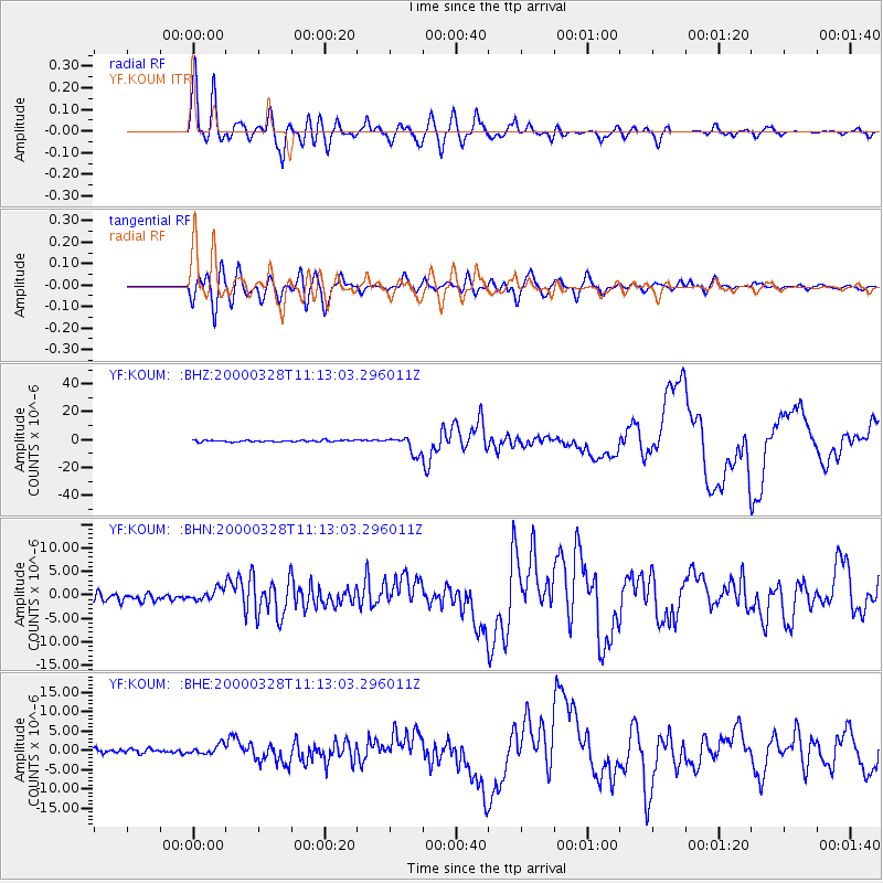
Earthquake location: Volcano Islands, Japan Region
Earthquake latitude/longitude: 22.3/143.7
Earthquake time(UTC): 2000/03/28 (088) 11:00:22 GMT
Earthquake Depth: 126 km
Earthquake Magnitude: 6.8 MB, 7.6 MS, 7.6 MW, 7.6 MW
Earthquake Catalog/Contributor: WHDF/NEIC
Network: YF Midsea - Mantle Investigation of the Deep Suture between Eurasia and Africa
Station: KOUM YF.KOUM
Lat/Lon: 37.70 N/26.84 E
Elevation: 340 m
Distance: 95.9 deg
Az: 314.676 deg
Baz: 56.105 deg
Ray Param: 0.04057824
Estimated Moho Depth: 22.0 km
Estimated Crust Vp/Vs: 1.88
Assumed Crust Vp: 5.989 km/s
Estimated Crust Vs: 3.181 km/s
Estimated Crust Poisson's Ratio: 0.30
Radial Match: 96.25078 %
Radial Bump: 400
Transverse Match: 91.47034 %
Transverse Bump: 400
SOD ConfigId: 3744
Insert Time: 2010-03-08 22:39:20.602 +0000
GWidth: 2.5
Max Bumps: 400
Tol: 0.001

Signal To Noise

ChannelStoNSTALTA
YF:KOUM: :BHN:20000328T11:13:03.296011Z1.13452591.1529036E-61.0161986E-6
YF:KOUM: :BHE:20000328T11:13:03.296011Z1.49295341.3945397E-69.340812E-7
YF:KOUM: :BHZ:20000328T11:13:03.296011Z10.2171476.197131E-66.0654224E-7
Arrivals
Ps3.3 SECOND
PpPs10 SECOND
PsPs/PpSs14 SECOND