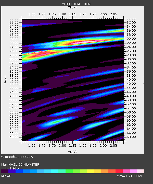
KOUM YF.KOUM - Earthquake Result Viewer
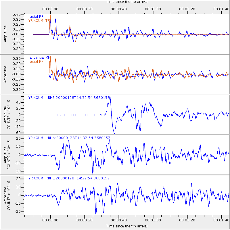
Earthquake location: Kuril Islands
Earthquake latitude/longitude: 43.0/146.8
Earthquake time(UTC): 2000/01/28 (028) 14:21:07 GMT
Earthquake Depth: 61 km
Earthquake Magnitude: 6.7 MB, 6.6 MS, 6.8 MW, 6.8 ME
Earthquake Catalog/Contributor: WHDF/NEIC
Network: YF Midsea - Mantle Investigation of the Deep Suture between Eurasia and Africa
Station: KOUM YF.KOUM
Lat/Lon: 37.70 N/26.84 E
Elevation: 340 m
Distance: 82.9 deg
Az: 316.195 deg
Baz: 39.775 deg
Ray Param: 0.046447333
Estimated Moho Depth: 21.25 km
Estimated Crust Vp/Vs: 1.91
Assumed Crust Vp: 5.989 km/s
Estimated Crust Vs: 3.127 km/s
Estimated Crust Poisson's Ratio: 0.31
Radial Match: 93.44775 %
Radial Bump: 400
Transverse Match: 89.44331 %
Transverse Bump: 400
SOD ConfigId: 3744
Insert Time: 2010-03-08 22:39:22.459 +0000
GWidth: 2.5
Max Bumps: 400
Tol: 0.001

Signal To Noise

ChannelStoNSTALTA
YF:KOUM: :BHN:20000128T14:32:54.368015Z12.1164636.9834787E-65.763628E-7
YF:KOUM: :BHE:20000128T14:32:54.368015Z7.37789874.204913E-65.6993366E-7
YF:KOUM: :BHZ:20000128T14:32:54.368015Z64.657472.4704663E-53.820852E-7
Arrivals
Ps3.3 SECOND
PpPs10 SECOND
PsPs/PpSs13 SECOND