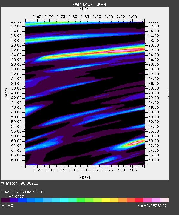
KOUM YF.KOUM - Earthquake Result Viewer
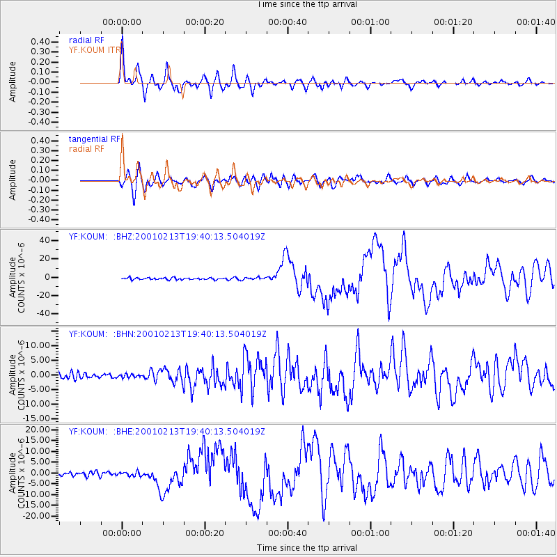
Earthquake location: Southern Sumatra, Indonesia
Earthquake latitude/longitude: -4.7/102.6
Earthquake time(UTC): 2001/02/13 (044) 19:28:30 GMT
Earthquake Depth: 36 km
Earthquake Magnitude: 6.2 MB, 7.2 MS, 7.4 MW, 7.0 ME
Earthquake Catalog/Contributor: WHDF/NEIC
Network: YF Midsea - Mantle Investigation of the Deep Suture between Eurasia and Africa
Station: KOUM YF.KOUM
Lat/Lon: 37.70 N/26.84 E
Elevation: 340 m
Distance: 81.6 deg
Az: 309.018 deg
Baz: 102.49 deg
Ray Param: 0.047400594
Estimated Moho Depth: 60.5 km
Estimated Crust Vp/Vs: 2.06
Assumed Crust Vp: 5.989 km/s
Estimated Crust Vs: 2.904 km/s
Estimated Crust Poisson's Ratio: 0.35
Radial Match: 96.38981 %
Radial Bump: 400
Transverse Match: 90.821625 %
Transverse Bump: 400
SOD ConfigId: 16820
Insert Time: 2010-03-08 22:39:27.449 +0000
GWidth: 2.5
Max Bumps: 400
Tol: 0.001

Signal To Noise

ChannelStoNSTALTA
YF:KOUM: :BHN:20010213T19:40:13.504019Z0.467364464.6760667E-71.0005182E-6
YF:KOUM: :BHE:20010213T19:40:13.504019Z0.85918089.266355E-71.0785104E-6
YF:KOUM: :BHZ:20010213T19:40:13.504019Z1.2349921.22138E-69.889781E-7
Arrivals
Ps11 SECOND
PpPs30 SECOND
PsPs/PpSs41 SECOND