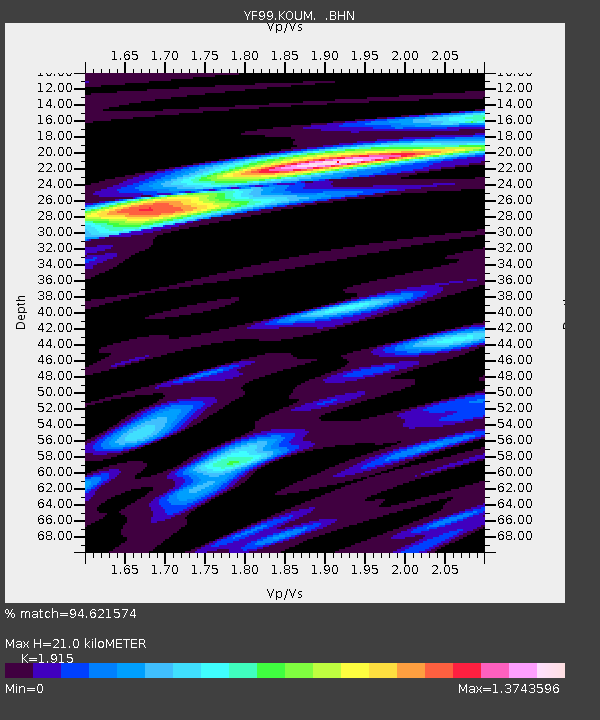
KOUM YF.KOUM - Earthquake Result Viewer
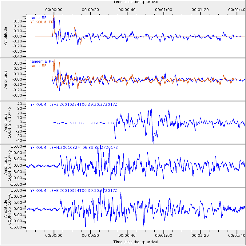
Earthquake location: Western Honshu, Japan
Earthquake latitude/longitude: 34.1/132.5
Earthquake time(UTC): 2001/03/24 (083) 06:27:53 GMT
Earthquake Depth: 50 km
Earthquake Magnitude: 6.4 MB, 6.5 MS, 6.8 MW, 6.4 ME
Earthquake Catalog/Contributor: WHDF/NEIC
Network: YF Midsea - Mantle Investigation of the Deep Suture between Eurasia and Africa
Station: KOUM YF.KOUM
Lat/Lon: 37.70 N/26.84 E
Elevation: 340 m
Distance: 80.7 deg
Az: 309.304 deg
Baz: 54.067 deg
Ray Param: 0.04801618
Estimated Moho Depth: 21.0 km
Estimated Crust Vp/Vs: 1.91
Assumed Crust Vp: 5.989 km/s
Estimated Crust Vs: 3.127 km/s
Estimated Crust Poisson's Ratio: 0.31
Radial Match: 94.621574 %
Radial Bump: 400
Transverse Match: 93.64128 %
Transverse Bump: 400
SOD ConfigId: 4714
Insert Time: 2010-03-08 22:39:28.857 +0000
GWidth: 2.5
Max Bumps: 400
Tol: 0.001

Signal To Noise

ChannelStoNSTALTA
YF:KOUM: :BHN:20010324T06:39:30.272017Z5.19332932.629791E-65.063786E-7
YF:KOUM: :BHE:20010324T06:39:30.272017Z3.80655052.4810238E-66.5177744E-7
YF:KOUM: :BHZ:20010324T06:39:30.272017Z19.9286231.0688208E-55.363244E-7
Arrivals
Ps3.3 SECOND
PpPs10.0 SECOND
PsPs/PpSs13 SECOND