You are here: Home > Network List > YF99 - Midsea - Mantle Investigation of the Deep Suture between Eurasia and Africa Stations List
> Station KOUM YF.KOUM > Earthquake Result Viewer
KOUM YF.KOUM - Earthquake Result Viewer
| Earthquake location: |
Southern Sumatra, Indonesia |
| Earthquake latitude/longitude: |
-4.0/101.7 |
| Earthquake time(UTC): |
2001/01/16 (016) 13:25:01 GMT |
| Earthquake Depth: |
33 km |
| Earthquake Magnitude: |
6.0 MB |
| Earthquake Catalog/Contributor: |
WHDF/NEIC |
|
| Network: |
YF Midsea - Mantle Investigation of the Deep Suture between Eurasia and Africa |
| Station: |
KOUM YF.KOUM |
| Lat/Lon: |
37.70 N/26.84 E |
| Elevation: |
340 m |
|
| Distance: |
80.5 deg |
| Az: |
309.072 deg |
| Baz: |
102.444 deg |
| Ray Param: |
0.048159428 |
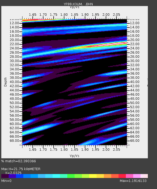
| Estimated Moho Depth: |
21.75 km |
| Estimated Crust Vp/Vs: |
2.03 |
| Assumed Crust Vp: |
5.989 km/s |
| Estimated Crust Vs: |
2.947 km/s |
| Estimated Crust Poisson's Ratio: |
0.34 |
|
| Radial Match: |
82.390366 % |
| Radial Bump: |
400 |
| Transverse Match: |
71.91782 % |
| Transverse Bump: |
400 |
| SOD ConfigId: |
3744 |
| Insert Time: |
2010-03-08 22:39:31.069 +0000 |
| GWidth: |
2.5 |
| Max Bumps: |
400 |
| Tol: |
0.001 |
|
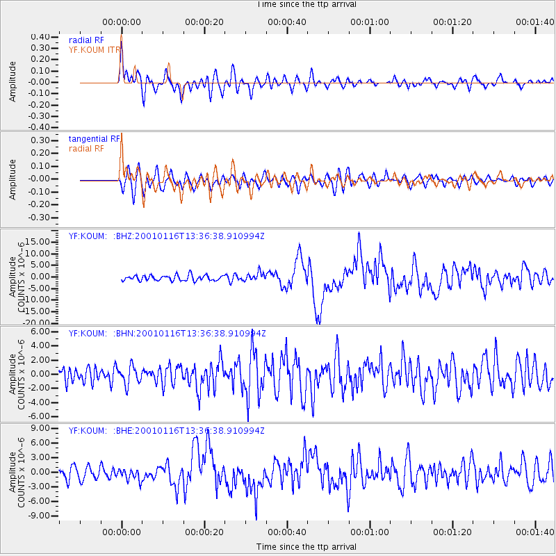
Signal To Noise
| Channel | StoN | STA | LTA |
| YF:KOUM: :BHN:20010116T13:36:38.910994Z | 1.3343562 | 1.2676062E-6 | 9.499758E-7 |
| YF:KOUM: :BHE:20010116T13:36:38.910994Z | 0.9635054 | 1.1882428E-6 | 1.2332497E-6 |
| YF:KOUM: :BHZ:20010116T13:36:38.910994Z | 1.5652231 | 1.8019355E-6 | 1.1512324E-6 |
| Arrivals |
| Ps | 3.8 SECOND |
| PpPs | 11 SECOND |
| PsPs/PpSs | 15 SECOND |


