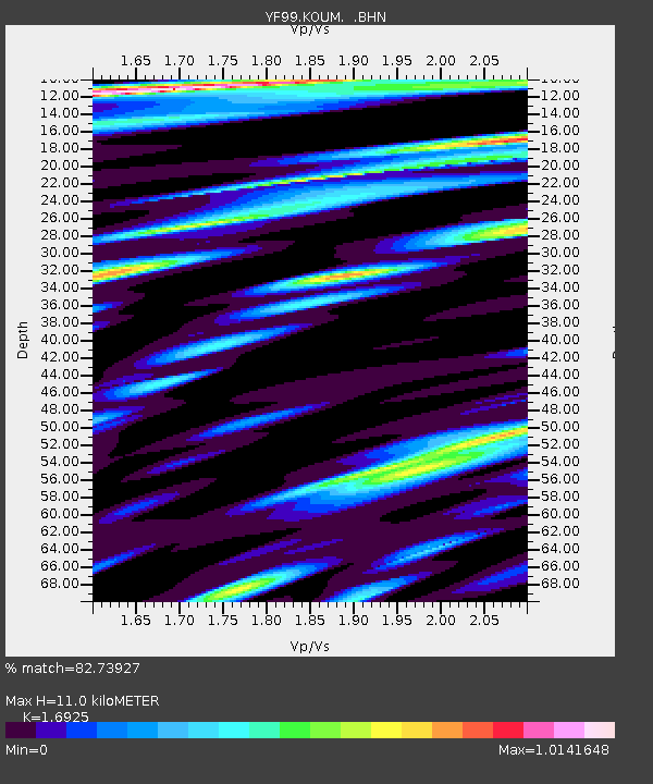
KOUM YF.KOUM - Earthquake Result Viewer
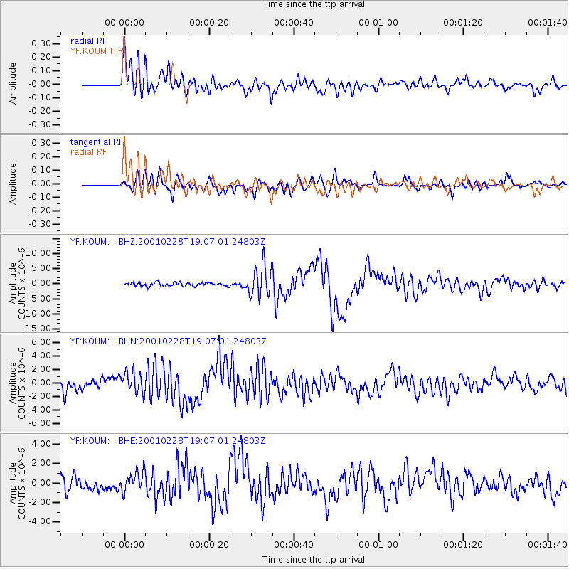
Earthquake location: Washington
Earthquake latitude/longitude: 47.1/-122.7
Earthquake time(UTC): 2001/02/28 (059) 18:54:32 GMT
Earthquake Depth: 52 km
Earthquake Magnitude: 6.5 MB, 6.6 MS, 6.8 MW, 6.7 ME
Earthquake Catalog/Contributor: WHDF/NEIC
Network: YF Midsea - Mantle Investigation of the Deep Suture between Eurasia and Africa
Station: KOUM YF.KOUM
Lat/Lon: 37.70 N/26.84 E
Elevation: 340 m
Distance: 91.2 deg
Az: 23.696 deg
Baz: 339.767 deg
Ray Param: 0.041607782
Estimated Moho Depth: 11.0 km
Estimated Crust Vp/Vs: 1.69
Assumed Crust Vp: 5.989 km/s
Estimated Crust Vs: 3.539 km/s
Estimated Crust Poisson's Ratio: 0.23
Radial Match: 82.73927 %
Radial Bump: 400
Transverse Match: 74.16623 %
Transverse Bump: 400
SOD ConfigId: 3744
Insert Time: 2010-03-08 22:39:35.174 +0000
GWidth: 2.5
Max Bumps: 400
Tol: 0.001

Signal To Noise

ChannelStoNSTALTA
YF:KOUM: :BHN:20010228T19:07:01.24803Z2.44151021.6478244E-66.7492016E-7
YF:KOUM: :BHE:20010228T19:07:01.24803Z1.27795029.975141E-77.805579E-7
YF:KOUM: :BHZ:20010228T19:07:01.24803Z9.1189085.1631955E-65.662077E-7
Arrivals
Ps1.3 SECOND
PpPs4.9 SECOND
PsPs/PpSs6.1 SECOND