You are here: Home > Network List > YF99 - Midsea - Mantle Investigation of the Deep Suture between Eurasia and Africa Stations List
> Station KOUM YF.KOUM > Earthquake Result Viewer
KOUM YF.KOUM - Earthquake Result Viewer
| Earthquake location: |
Hokkaido, Japan Region |
| Earthquake latitude/longitude: |
43.1/145.9 |
| Earthquake time(UTC): |
2001/04/26 (116) 17:48:57 GMT |
| Earthquake Depth: |
86 km |
| Earthquake Magnitude: |
5.7 MB, 6.0 MW, 6.0 MW |
| Earthquake Catalog/Contributor: |
WHDF/NEIC |
|
| Network: |
YF Midsea - Mantle Investigation of the Deep Suture between Eurasia and Africa |
| Station: |
KOUM YF.KOUM |
| Lat/Lon: |
37.70 N/26.84 E |
| Elevation: |
340 m |
|
| Distance: |
82.4 deg |
| Az: |
315.631 deg |
| Baz: |
40.224 deg |
| Ray Param: |
0.046731178 |
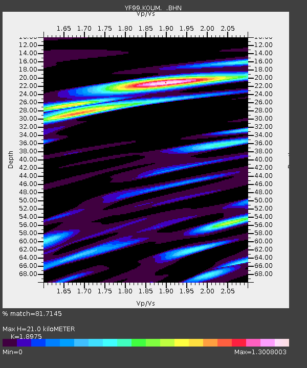
| Estimated Moho Depth: |
21.0 km |
| Estimated Crust Vp/Vs: |
1.90 |
| Assumed Crust Vp: |
5.989 km/s |
| Estimated Crust Vs: |
3.156 km/s |
| Estimated Crust Poisson's Ratio: |
0.31 |
|
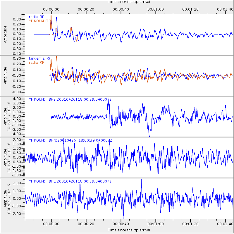
| Radial Match: |
81.7145 % |
| Radial Bump: |
400 |
| Transverse Match: |
69.57431 % |
| Transverse Bump: |
400 |
| SOD ConfigId: |
4714 |
| Insert Time: |
2010-03-08 22:39:36.809 +0000 |
| GWidth: |
2.5 |
| Max Bumps: |
400 |
| Tol: |
0.001 |
|
Signal To Noise
| Channel | StoN | STA | LTA |
| YF:KOUM: :BHN:20010426T18:00:39.040007Z | 1.9548285 | 5.469995E-7 | 2.798197E-7 |
| YF:KOUM: :BHE:20010426T18:00:39.040007Z | 0.8285159 | 3.4935016E-7 | 4.2165777E-7 |
| YF:KOUM: :BHZ:20010426T18:00:39.040007Z | 4.8186975 | 1.6742645E-6 | 3.4745167E-7 |
| Arrivals |
| Ps | 3.2 SECOND |
| PpPs | 9.9 SECOND |
| PsPs/PpSs | 13 SECOND |


