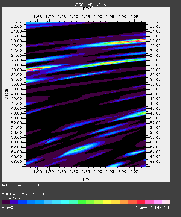
MARJ YF.MARJ - Earthquake Result Viewer
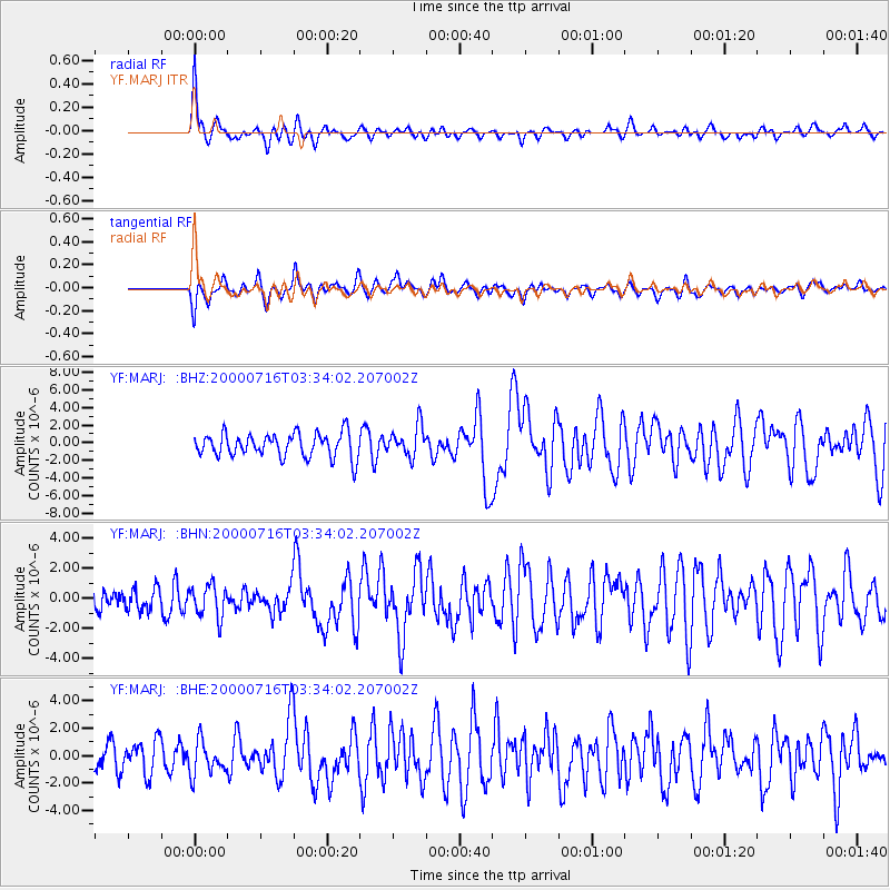
Earthquake location: Philippine Islands Region
Earthquake latitude/longitude: 20.3/122.0
Earthquake time(UTC): 2000/07/16 (198) 03:21:45 GMT
Earthquake Depth: 33 km
Earthquake Magnitude: 6.1 MB, 6.3 MS, 6.4 MW, 6.4 MW
Earthquake Catalog/Contributor: WHDF/NEIC
Network: YF Midsea - Mantle Investigation of the Deep Suture between Eurasia and Africa
Station: MARJ YF.MARJ
Lat/Lon: 32.52 N/20.88 E
Elevation: 300 m
Distance: 88.3 deg
Az: 303.983 deg
Baz: 67.158 deg
Ray Param: 0.042683505
Estimated Moho Depth: 17.5 km
Estimated Crust Vp/Vs: 2.10
Assumed Crust Vp: 5.657 km/s
Estimated Crust Vs: 2.697 km/s
Estimated Crust Poisson's Ratio: 0.35
Radial Match: 82.10129 %
Radial Bump: 400
Transverse Match: 68.666214 %
Transverse Bump: 400
SOD ConfigId: 16820
Insert Time: 2010-03-08 22:39:39.394 +0000
GWidth: 2.5
Max Bumps: 400
Tol: 0.001

Signal To Noise

ChannelStoNSTALTA
YF:MARJ: :BHN:20000716T03:34:02.207002Z1.51647081.0773068E-67.104039E-7
YF:MARJ: :BHE:20000716T03:34:02.207002Z0.94805641.2036946E-61.2696446E-6
YF:MARJ: :BHZ:20000716T03:34:02.207002Z1.3025891.7610225E-61.3519402E-6
Arrivals
Ps3.4 SECOND
PpPs9.4 SECOND
PsPs/PpSs13 SECOND