
Station YF MARJ - YF.MARJ
Network: YF99 - Midsea - Mantle Investigation of the Deep Suture between Eurasia and Africa
Nearby stations (2 deg radius)
| Station | Name | (Lat, Lon) | Start / End | Elevation |
| MARJ | YF.MARJ | (32.52, 20.88) | 2000-05-22 / 2001-12-31 | 0.3 km |
| Crust2 Type: | S7,continental slope, margin, transition 7 km seds. |
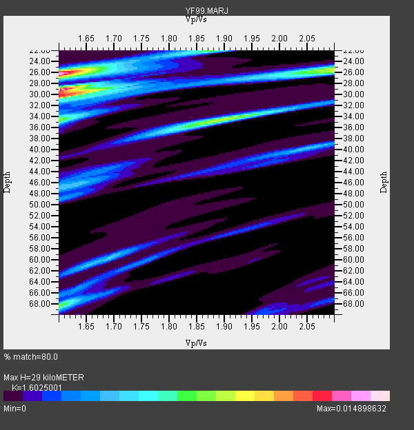
| Thickness Estimate: | 29 km |
| Thickness StdDev: | 13 km |
| Vp/Vs Estimate: | 1.60 |
| Vp/Vs StdDev: | 0.08 |
| Vs Estimate: | 3.53 km/s |
| Poisson's Ratio: | 0.18 |
| Peak Value: | 0.01 |
| Assumed Vp: | 5.657 km/s |
| Ps Weight: | 0.33333334 |
| PpPs Weight: | 0.33333334 |
| PsPs Weight: | 0.33333328 |
| Residual Complexity: | 0.786 |
| Nearby stations H: | +- |
| (2.0 deg) Vp/Vs: | +- |
3 with match > 90% ( 33.333332 %) and 9 with match > 80% ( 100.0 %) out of 9.
Download stack as xyz text file.
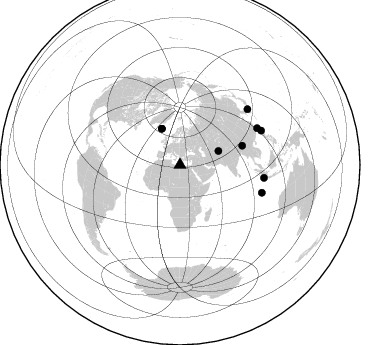
Azimuth Distribution of Events:
Prior Results for this Station
| Study | Thickness | Vp/Vs | Vp | Vs | Poissons Ratio | Extra |
| EARS | 29 km | 1.60 | 5.657 km/s | 3.53 km/s | 0.18 | |
| Crust2.0 | 27 km | 1.82 | 5.657 km/s | 3.113 km/s | 0.28 | S7,continental slope, margin, transition 7 km seds. |
| Global Maxima | 29 km | 1.60 | 5.657 km/s | 3.53 km/s | 0.18 | amp=0.014898632 |
| Local Maxima 1 | 26 km | 1.60 | 5.657 km/s | 3.536 km/s | 0.18 | amp=0.011858957 |
| Local Maxima 2 | 25 km | 2.10 | 5.657 km/s | 2.697 km/s | 0.35 | amp=0.008742603 |
| Local Maxima 3 | 34 km | 1.89 | 5.657 km/s | 2.989 km/s | 0.31 | amp=0.008454298 |
| Local Maxima 4 | 34 km | 1.60 | 5.657 km/s | 3.536 km/s | 0.18 | amp=0.008042493 |
| Predicted Arrivals for vertical incidence (zero ray parameter) | |
| Ps | 3.09 SECOND |
| PpPs | 13.34 SECOND |
| PsPs/PpSs | 16.43 SECOND |
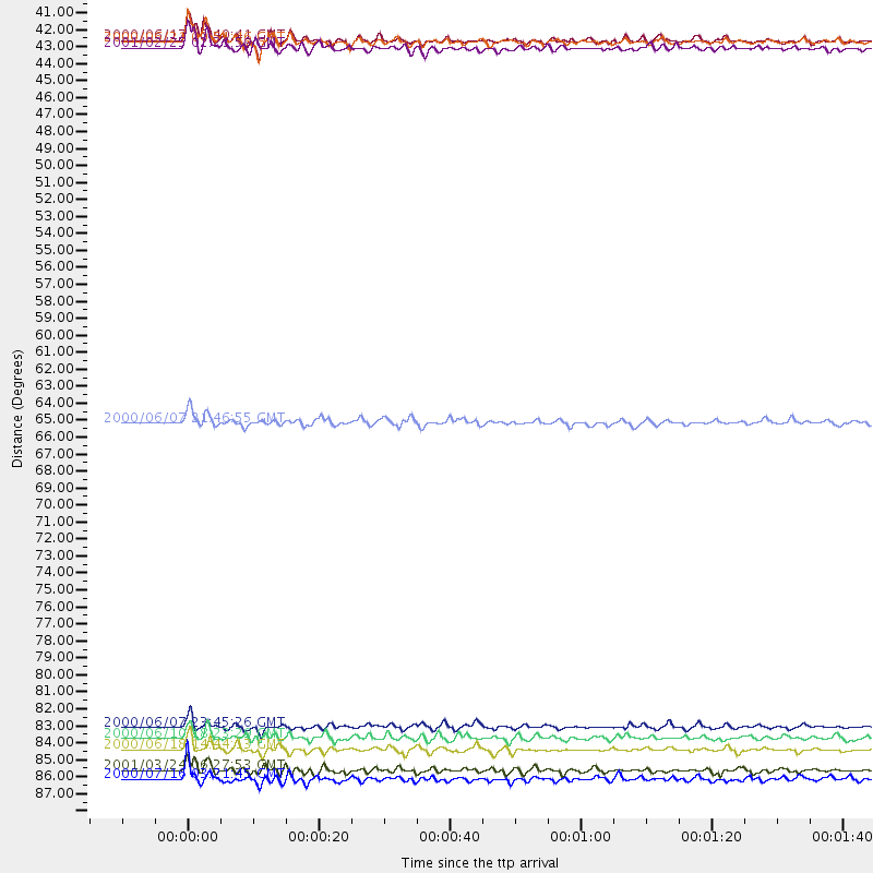
Events Processed for this Station
Download zip of receiver functions as SAC
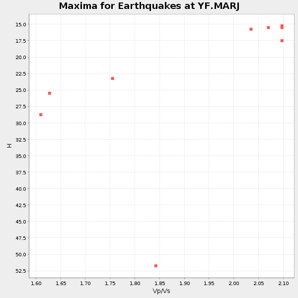
Plot maxima for each earthquake.
Events Used in the Stack
(9 events)| Radial Match | Distance | Baz | FERegion | Time | Lat/Lon | Depth | Magnitude |
| 94.33074 | 86.3 deg | 108.76 deg | South Indian Ocean | 2000/06/18 14:44:13 GMT | (-13.8, 97.5) | 10 km | 6.8 MB, 7.8 MS, 7.8 MW, 7.6 MW |
| 92.38371 | 65.3 deg | 72.912 deg | Myanmar | 2000/06/07 21:46:55 GMT | (26.9, 97.2) | 33 km | 6.3 MB, 6.5 MS, 6.4 MW, 6.4 MW |
| 90.71425 | 40.7 deg | 333.267 deg | Iceland | 2000/06/21 00:51:46 GMT | (64.0, -20.8) | 10 km | 6.1 MB, 6.6 MS, 6.5 MW, 6.4 MW |
| 88.39575 | 41.0 deg | 70.233 deg | Hindu Kush Region, Afghanistan | 2001/02/25 02:21:59 GMT | (36.4, 70.9) | 202 km | 5.8 MB, 6.3 MW, 6.1 MW |
| 87.551 | 40.5 deg | 333.342 deg | Iceland | 2000/06/17 15:40:41 GMT | (64.0, -20.5) | 10 km | 5.7 MB, 6.6 MS, 6.8 MW, 6.5 MW |
| 86.84789 | 84.9 deg | 98.7 deg | Southern Sumatra, Indonesia | 2000/06/07 23:45:26 GMT | (-4.6, 101.9) | 33 km | 6.1 MB, 6.7 MS, 6.7 MW, 6.5 MW |
| 86.21035 | 85.6 deg | 64.607 deg | Taiwan | 2000/06/10 18:23:29 GMT | (23.8, 121.2) | 33 km | 6.2 MB, 6.2 MS, 6.4 MW, 6.3 MW |
| 85.10074 | 87.7 deg | 50.537 deg | Western Honshu, Japan | 2001/03/24 06:27:53 GMT | (34.1, 132.5) | 50 km | 6.4 MB, 6.5 MS, 6.8 MW, 6.4 ME |
| 82.10129 | 88.3 deg | 67.158 deg | Philippine Islands Region | 2000/07/16 03:21:45 GMT | (20.3, 122.0) | 33 km | 6.1 MB, 6.3 MS, 6.4 MW, 6.4 MW |
Losers
(0 events)| Radial Match | Distance | Baz | FERegion | Time | Lat/Lon | Depth | Magnitude | Reason |
