You are here: Home > Network List > YF99 - Midsea - Mantle Investigation of the Deep Suture between Eurasia and Africa Stations List
> Station MARJ YF.MARJ > Earthquake Result Viewer
MARJ YF.MARJ - Earthquake Result Viewer
| Earthquake location: |
Hindu Kush Region, Afghanistan |
| Earthquake latitude/longitude: |
36.4/70.9 |
| Earthquake time(UTC): |
2001/02/25 (056) 02:21:59 GMT |
| Earthquake Depth: |
202 km |
| Earthquake Magnitude: |
5.8 MB, 6.3 MW, 6.1 MW |
| Earthquake Catalog/Contributor: |
WHDF/NEIC |
|
| Network: |
YF Midsea - Mantle Investigation of the Deep Suture between Eurasia and Africa |
| Station: |
MARJ YF.MARJ |
| Lat/Lon: |
32.52 N/20.88 E |
| Elevation: |
300 m |
|
| Distance: |
41.0 deg |
| Az: |
279.693 deg |
| Baz: |
70.233 deg |
| Ray Param: |
0.073241614 |
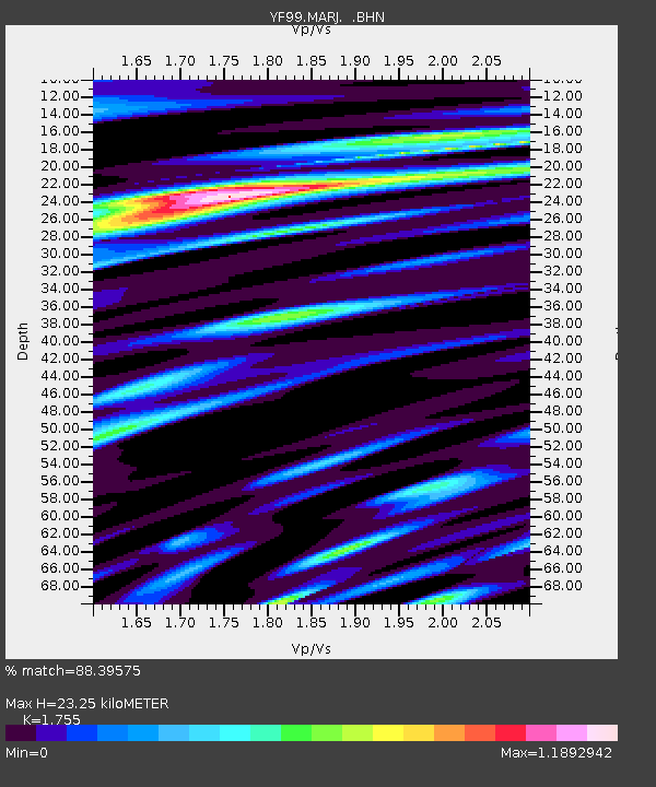
| Estimated Moho Depth: |
23.25 km |
| Estimated Crust Vp/Vs: |
1.75 |
| Assumed Crust Vp: |
5.657 km/s |
| Estimated Crust Vs: |
3.224 km/s |
| Estimated Crust Poisson's Ratio: |
0.26 |
|
| Radial Match: |
88.39575 % |
| Radial Bump: |
400 |
| Transverse Match: |
84.153465 % |
| Transverse Bump: |
400 |
| SOD ConfigId: |
16820 |
| Insert Time: |
2010-03-08 22:39:54.836 +0000 |
| GWidth: |
2.5 |
| Max Bumps: |
400 |
| Tol: |
0.001 |
|
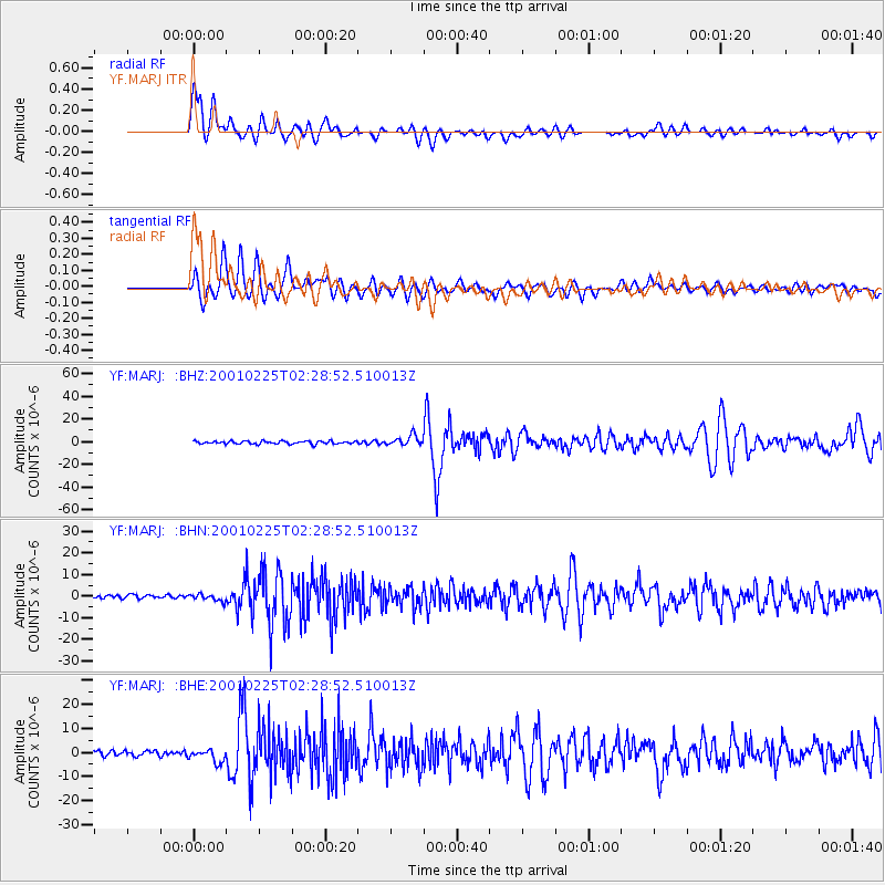
Signal To Noise
| Channel | StoN | STA | LTA |
| YF:MARJ: :BHN:20010225T02:28:52.510013Z | 1.4942797 | 1.4819125E-6 | 9.917236E-7 |
| YF:MARJ: :BHE:20010225T02:28:52.510013Z | 2.1816738 | 2.7104365E-6 | 1.2423658E-6 |
| YF:MARJ: :BHZ:20010225T02:28:52.510013Z | 3.4663727 | 4.415045E-6 | 1.2736787E-6 |
| Arrivals |
| Ps | 3.3 SECOND |
| PpPs | 11 SECOND |
| PsPs/PpSs | 14 SECOND |


