You are here: Home > Network List > XC00 - Yellowstone Intermountain Seismic Array Stations List
> Station Y35 Y35 > Earthquake Result Viewer
Y35 Y35 - Earthquake Result Viewer
| Earthquake location: |
Tonga Islands |
| Earthquake latitude/longitude: |
-17.9/-175.3 |
| Earthquake time(UTC): |
2000/10/31 (305) 18:43:20 GMT |
| Earthquake Depth: |
33 km |
| Earthquake Magnitude: |
5.8 MB, 5.9 MS, 6.1 MW |
| Earthquake Catalog/Contributor: |
WHDF/NEIC |
|
| Network: |
XC Yellowstone Intermountain Seismic Array |
| Station: |
Y35 Y35 |
| Lat/Lon: |
42.57 N/108.04 W |
| Elevation: |
2062 m |
|
| Distance: |
86.2 deg |
| Az: |
43.068 deg |
| Baz: |
241.686 deg |
| Ray Param: |
0.044178862 |
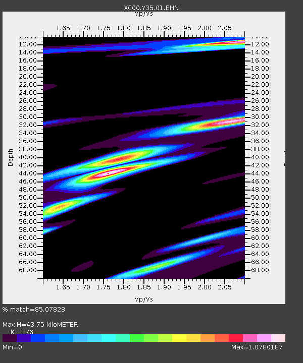
| Estimated Moho Depth: |
43.75 km |
| Estimated Crust Vp/Vs: |
1.76 |
| Assumed Crust Vp: |
6.161 km/s |
| Estimated Crust Vs: |
3.5 km/s |
| Estimated Crust Poisson's Ratio: |
0.26 |
|
| Radial Match: |
85.07828 % |
| Radial Bump: |
400 |
| Transverse Match: |
64.98992 % |
| Transverse Bump: |
400 |
| SOD ConfigId: |
3744 |
| Insert Time: |
2010-02-26 14:57:17.838 +0000 |
| GWidth: |
2.5 |
| Max Bumps: |
400 |
| Tol: |
0.001 |
|
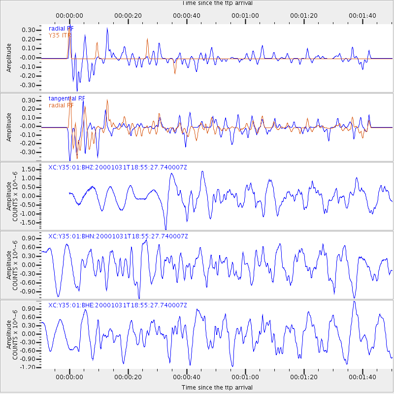
Signal To Noise
| Channel | StoN | STA | LTA |
| XC:Y35:01:BHN:20001031T18:55:27.740007Z | 0.98854357 | 5.451896E-7 | 5.5150787E-7 |
| XC:Y35:01:BHE:20001031T18:55:27.740007Z | 1.705642 | 4.9339644E-7 | 2.8927317E-7 |
| XC:Y35:01:BHZ:20001031T18:55:27.740007Z | 2.0973866 | 8.3630874E-7 | 3.9873845E-7 |
| Arrivals |
| Ps | 5.5 SECOND |
| PpPs | 19 SECOND |
| PsPs/PpSs | 25 SECOND |


