
Station XC Y35 - Y35
Network: XC00 - Yellowstone Intermountain Seismic Array
Nearby stations (2 deg radius)
| Station | Name | (Lat, Lon) | Start / End | Elevation |
| Y35 | Y35 | (42.57, -108.04) | 2000-06-20 / 2001-12-31 | 2062 m |
| Crust2 Type: | Q0,orogen/46km no ice, Rockies, Tarim Basin, 4 km seds. |
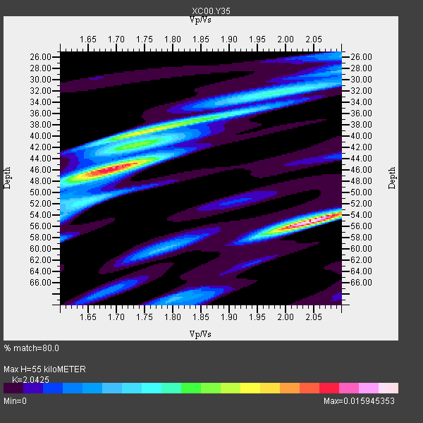
| Thickness Estimate: | 55 km |
| Thickness StdDev: | 6.8 km |
| Vp/Vs Estimate: | 2.04 |
| Vp/Vs StdDev: | 0.16 |
| Vs Estimate: | 3.016 km/s |
| Poisson's Ratio: | 0.34 |
| Peak Value: | 0.02 |
| Assumed Vp: | 6.161 km/s |
| Ps Weight: | 0.33333334 |
| PpPs Weight: | 0.33333334 |
| PsPs Weight: | 0.33333328 |
| Residual Complexity: | 0.859 |
| Nearby stations H: | +- |
| (2.0 deg) Vp/Vs: | +- |
5 with match > 90% ( 50.0 %) and 10 with match > 80% ( 100.0 %) out of 10.
Download stack as xyz text file.
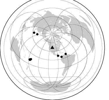
Azimuth Distribution of Events:
Prior Results for this Station
| Study | Thickness | Vp/Vs | Vp | Vs | Poissons Ratio | Extra |
| EARS | 55 km | 2.04 | 6.161 km/s | 3.016 km/s | 0.34 | |
| Crust2.0 | 46 km | 1.75 | 6.161 km/s | 3.511 km/s | 0.26 | Q0,orogen/46km no ice, Rockies, Tarim Basin, 4 km seds. |
| Global Maxima | 55 km | 2.04 | 6.161 km/s | 3.016 km/s | 0.34 | amp=0.015945353 |
| Local Maxima 1 | 46 km | 1.70 | 6.161 km/s | 3.635 km/s | 0.23 | amp=0.014384182 |
| Local Maxima 2 | 39 km | 1.74 | 6.161 km/s | 3.541 km/s | 0.25 | amp=0.00899955 |
| Local Maxima 3 | 32 km | 2.00 | 6.161 km/s | 3.088 km/s | 0.33 | amp=0.0060888627 |
| Local Maxima 4 | 42 km | 1.73 | 6.161 km/s | 3.561 km/s | 0.25 | amp=0.0038846529 |
| Predicted Arrivals for vertical incidence (zero ray parameter) | |
| Ps | 9.31 SECOND |
| PpPs | 27.16 SECOND |
| PsPs/PpSs | 36.47 SECOND |
Events Processed for this Station
Download zip of receiver functions as SAC
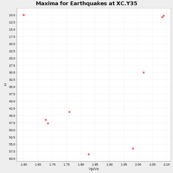
Plot maxima for each earthquake.
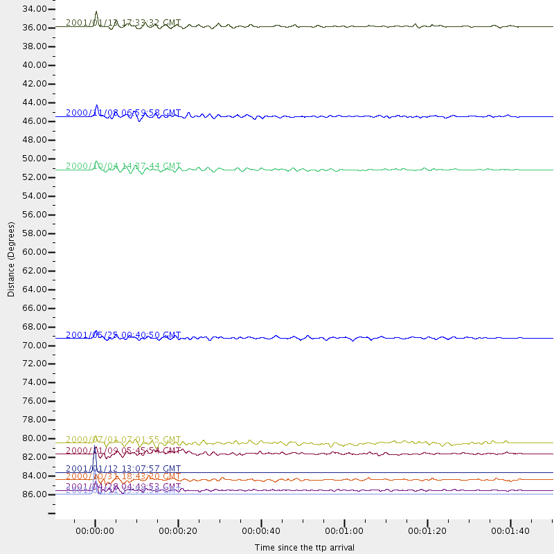
Events Used in the Stack
(10 events)| Radial Match | Distance | Baz | FERegion | Time | Lat/Lon | Depth | Magnitude |
| 99.99901 | 87.8 deg | 242.043 deg | Fiji Islands Region | 2001/01/11 19:59:39 GMT | (-18.8, -176.7) | 10 km | 5.4 MB, 5.4 MS, 5.8 MW, 5.7 MW |
| 99.99866 | 85.3 deg | 242.088 deg | Tonga Islands | 2001/01/12 13:07:57 GMT | (-17.0, -175.0) | 258 km | 5.2 MB, 5.5 MW |
| 91.89905 | 44.3 deg | 134.346 deg | Panama-Colombia Border Region | 2000/11/08 06:59:58 GMT | (7.0, -77.8) | 17 km | 6.0 MB, 6.4 MS, 6.5 MW, 6.2 ML |
| 91.19452 | 33.9 deg | 144.532 deg | El Salvador | 2001/01/13 17:33:32 GMT | (13.0, -88.7) | 60 km | 6.4 MB, 7.8 MS, 7.7 MW, 7.5 ME |
| 90.01516 | 69.9 deg | 311.938 deg | Kuril Islands | 2001/05/25 00:40:50 GMT | (44.3, 148.4) | 33 km | 6.1 MB, 6.7 MS, 6.7 MW, 6.6 MW |
| 88.15036 | 50.4 deg | 114.723 deg | Windward Islands | 2000/10/04 14:37:44 GMT | (11.1, -62.6) | 110 km | 5.6 MB, 5.4 MS, 6.1 MW, 5.9 MD |
| 85.07828 | 86.2 deg | 241.686 deg | Tonga Islands | 2000/10/31 18:43:20 GMT | (-17.9, -175.3) | 33 km | 5.8 MB, 5.9 MS, 6.1 MW |
| 84.686844 | 82.0 deg | 309.53 deg | Near S. Coast Of Honshu, Japan | 2000/07/01 07:01:55 GMT | (34.2, 139.1) | 10 km | 6.0 MB, 6.1 MS, 6.2 MW, 6.2 MW |
| 82.768166 | 83.2 deg | 242.006 deg | Tonga Islands | 2000/11/09 05:45:54 GMT | (-15.4, -173.4) | 53 km | 5.6 MB, 5.9 MW, 5.7 MW |
| 81.69417 | 87.4 deg | 242.677 deg | Fiji Islands Region | 2001/04/28 04:49:53 GMT | (-18.1, -176.9) | 352 km | 6.2 MB, 6.8 MW, 6.8 MW |
Losers
(0 events)| Radial Match | Distance | Baz | FERegion | Time | Lat/Lon | Depth | Magnitude | Reason |
