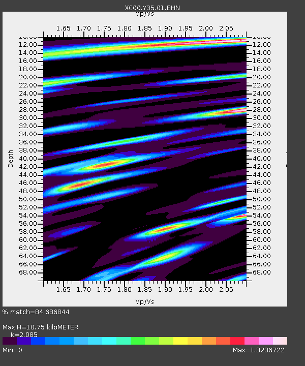
Y35 Y35 - Earthquake Result Viewer
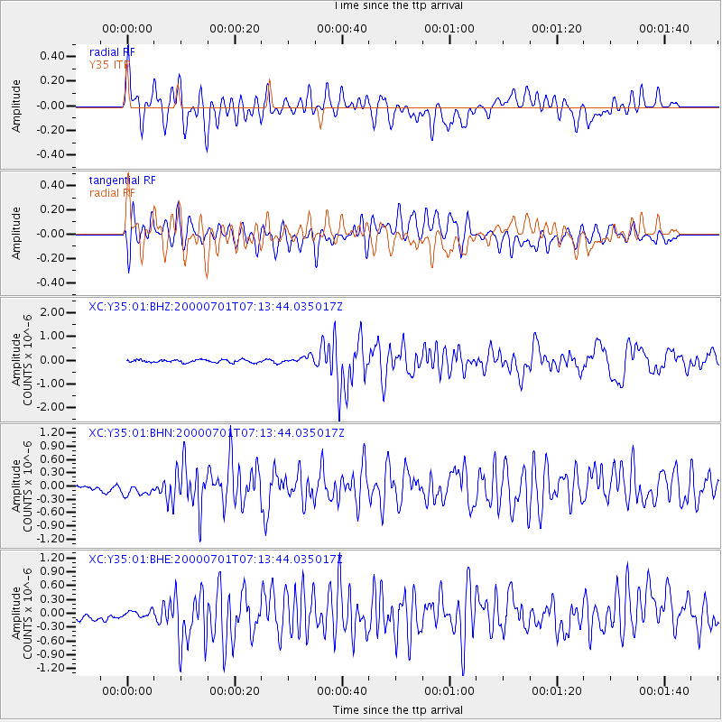
Earthquake location: Near S. Coast Of Honshu, Japan
Earthquake latitude/longitude: 34.2/139.1
Earthquake time(UTC): 2000/07/01 (183) 07:01:55 GMT
Earthquake Depth: 10 km
Earthquake Magnitude: 6.0 MB, 6.1 MS, 6.2 MW, 6.2 MW
Earthquake Catalog/Contributor: WHDF/NEIC
Network: XC Yellowstone Intermountain Seismic Array
Station: Y35 Y35
Lat/Lon: 42.57 N/108.04 W
Elevation: 2062 m
Distance: 82.0 deg
Az: 43.441 deg
Baz: 309.53 deg
Ray Param: 0.047217526
Estimated Moho Depth: 10.75 km
Estimated Crust Vp/Vs: 2.09
Assumed Crust Vp: 6.161 km/s
Estimated Crust Vs: 2.955 km/s
Estimated Crust Poisson's Ratio: 0.35
Radial Match: 84.686844 %
Radial Bump: 400
Transverse Match: 70.74904 %
Transverse Bump: 400
SOD ConfigId: 3744
Insert Time: 2010-02-26 14:57:18.624 +0000
GWidth: 2.5
Max Bumps: 400
Tol: 0.001

Signal To Noise

ChannelStoNSTALTA
XC:Y35:01:BHN:20000701T07:13:44.035017Z2.578462.0532366E-77.963035E-8
XC:Y35:01:BHE:20000701T07:13:44.035017Z0.66252639.790788E-81.4777962E-7
XC:Y35:01:BHZ:20000701T07:13:44.035017Z2.5545531.4829966E-75.805307E-8
Arrivals
Ps1.9 SECOND
PpPs5.3 SECOND
PsPs/PpSs7.2 SECOND