You are here: Home > Network List > SP - South Carolina Earth Physics Project Stations List
> Station BBLV Batesburg-Leesville High School, Lexington County, SC USA > Earthquake Result Viewer
BBLV Batesburg-Leesville High School, Lexington County, SC USA - Earthquake Result Viewer
| Earthquake location: |
Northern Algeria |
| Earthquake latitude/longitude: |
37.0/3.6 |
| Earthquake time(UTC): |
2003/05/21 (141) 18:44:20 GMT |
| Earthquake Depth: |
12 km |
| Earthquake Magnitude: |
6.5 MB, 6.9 MS, 6.8 MW, 6.7 MW |
| Earthquake Catalog/Contributor: |
WHDF/NEIC |
|
| Network: |
SP South Carolina Earth Physics Project |
| Station: |
BBLV Batesburg-Leesville High School, Lexington County, SC USA |
| Lat/Lon: |
33.92 N/81.53 W |
| Elevation: |
198 m |
|
| Distance: |
67.1 deg |
| Az: |
295.938 deg |
| Baz: |
60.022 deg |
| Ray Param: |
0.057155054 |
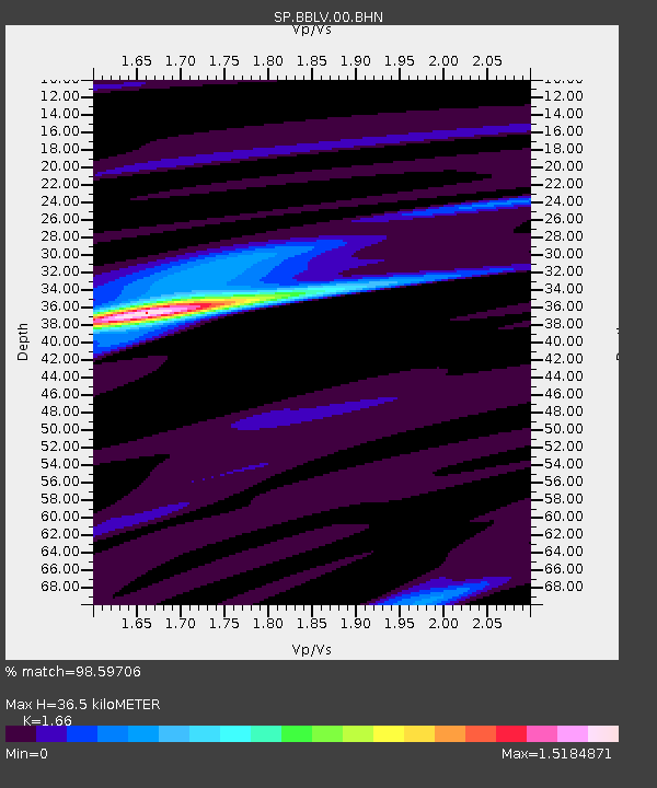
| Estimated Moho Depth: |
36.5 km |
| Estimated Crust Vp/Vs: |
1.66 |
| Assumed Crust Vp: |
6.565 km/s |
| Estimated Crust Vs: |
3.955 km/s |
| Estimated Crust Poisson's Ratio: |
0.22 |
|
| Radial Match: |
98.59706 % |
| Radial Bump: |
267 |
| Transverse Match: |
93.85109 % |
| Transverse Bump: |
400 |
| SOD ConfigId: |
2186 |
| Insert Time: |
2010-02-25 16:35:25.063 +0000 |
| GWidth: |
2.5 |
| Max Bumps: |
400 |
| Tol: |
0.001 |
|
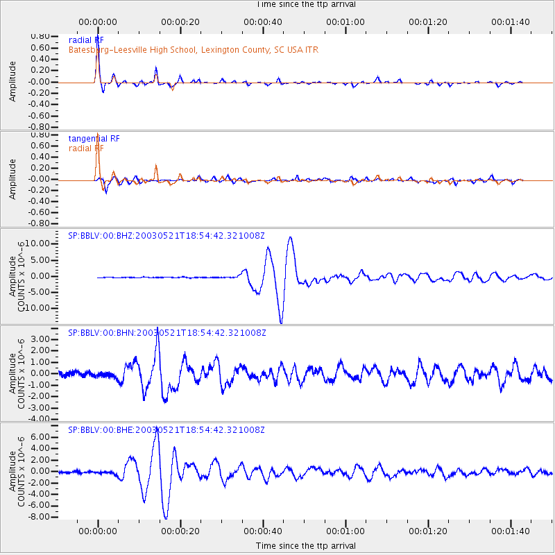
Signal To Noise
| Channel | StoN | STA | LTA |
| SP:BBLV:00:BHN:20030521T18:54:42.321008Z | 1.1697807 | 2.1687649E-7 | 1.8539926E-7 |
| SP:BBLV:00:BHE:20030521T18:54:42.321008Z | 1.8156806 | 2.3851518E-7 | 1.3136406E-7 |
| SP:BBLV:00:BHZ:20030521T18:54:42.321008Z | 3.8139267 | 3.7905033E-7 | 9.9385844E-8 |
| Arrivals |
| Ps | 3.8 SECOND |
| PpPs | 14 SECOND |
| PsPs/PpSs | 18 SECOND |


