You are here: Home > Network List > XC00 - Yellowstone Intermountain Seismic Array Stations List
> Station Y35 Y35 > Earthquake Result Viewer
Y35 Y35 - Earthquake Result Viewer
| Earthquake location: |
Tonga Islands |
| Earthquake latitude/longitude: |
-15.4/-173.4 |
| Earthquake time(UTC): |
2000/11/09 (314) 05:45:54 GMT |
| Earthquake Depth: |
53 km |
| Earthquake Magnitude: |
5.6 MB, 5.9 MW, 5.7 MW |
| Earthquake Catalog/Contributor: |
WHDF/NEIC |
|
| Network: |
XC Yellowstone Intermountain Seismic Array |
| Station: |
Y35 Y35 |
| Lat/Lon: |
42.57 N/108.04 W |
| Elevation: |
2062 m |
|
| Distance: |
83.2 deg |
| Az: |
42.559 deg |
| Baz: |
242.006 deg |
| Ray Param: |
0.046272244 |
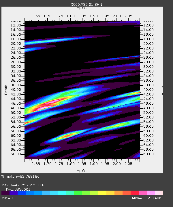
| Estimated Moho Depth: |
47.75 km |
| Estimated Crust Vp/Vs: |
1.69 |
| Assumed Crust Vp: |
6.161 km/s |
| Estimated Crust Vs: |
3.656 km/s |
| Estimated Crust Poisson's Ratio: |
0.23 |
|
| Radial Match: |
82.768166 % |
| Radial Bump: |
400 |
| Transverse Match: |
63.773403 % |
| Transverse Bump: |
400 |
| SOD ConfigId: |
16820 |
| Insert Time: |
2010-02-26 14:57:19.454 +0000 |
| GWidth: |
2.5 |
| Max Bumps: |
400 |
| Tol: |
0.001 |
|
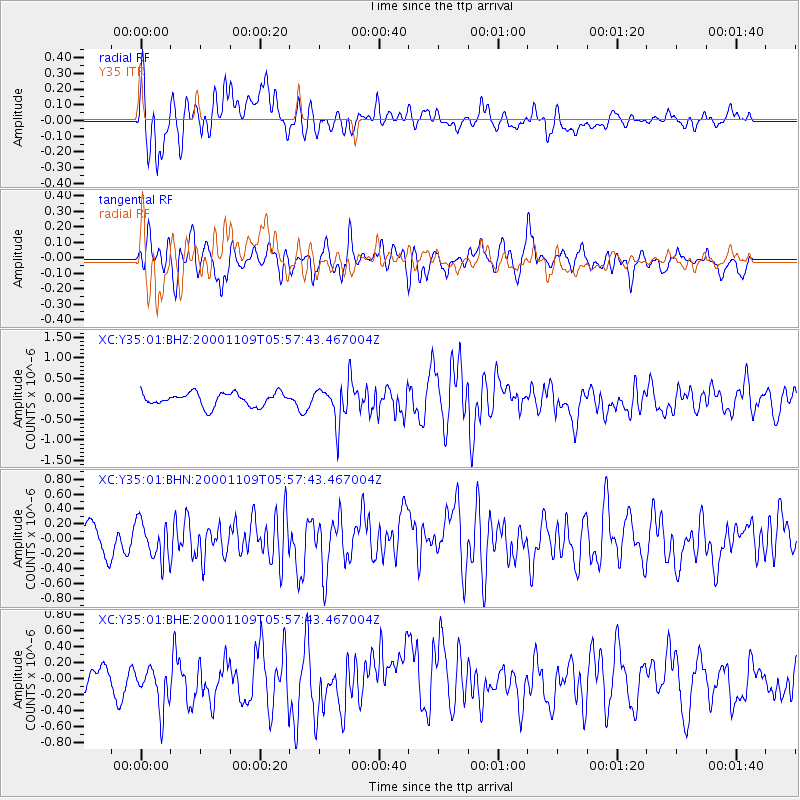
Signal To Noise
| Channel | StoN | STA | LTA |
| XC:Y35:01:BHN:20001109T05:57:43.467004Z | 1.0527887 | 2.5376806E-7 | 2.4104367E-7 |
| XC:Y35:01:BHE:20001109T05:57:43.467004Z | 1.418538 | 2.778972E-7 | 1.9590394E-7 |
| XC:Y35:01:BHZ:20001109T05:57:43.467004Z | 2.676631 | 4.3487861E-7 | 1.6247238E-7 |
| Arrivals |
| Ps | 5.4 SECOND |
| PpPs | 20 SECOND |
| PsPs/PpSs | 26 SECOND |


