You are here: Home > Network List > XC00 - Yellowstone Intermountain Seismic Array Stations List
> Station Y35 Y35 > Earthquake Result Viewer
Y35 Y35 - Earthquake Result Viewer
| Earthquake location: |
Tonga Islands |
| Earthquake latitude/longitude: |
-17.0/-175.0 |
| Earthquake time(UTC): |
2001/01/12 (012) 13:07:57 GMT |
| Earthquake Depth: |
258 km |
| Earthquake Magnitude: |
5.2 MB, 5.5 MW |
| Earthquake Catalog/Contributor: |
WHDF/NEIC |
|
| Network: |
XC Yellowstone Intermountain Seismic Array |
| Station: |
Y35 Y35 |
| Lat/Lon: |
42.57 N/108.04 W |
| Elevation: |
2062 m |
|
| Distance: |
85.3 deg |
| Az: |
43.004 deg |
| Baz: |
242.088 deg |
| Ray Param: |
0.04421425 |
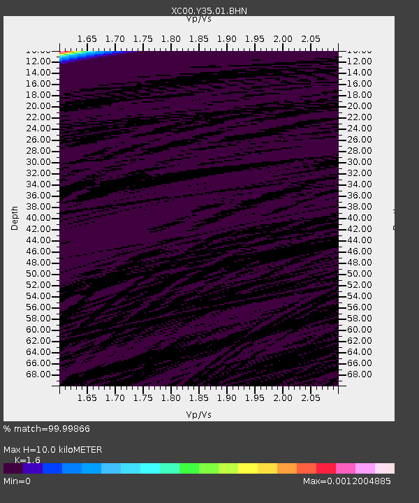
| Estimated Moho Depth: |
10.0 km |
| Estimated Crust Vp/Vs: |
1.60 |
| Assumed Crust Vp: |
6.161 km/s |
| Estimated Crust Vs: |
3.851 km/s |
| Estimated Crust Poisson's Ratio: |
0.18 |
|
| Radial Match: |
99.99866 % |
| Radial Bump: |
2 |
| Transverse Match: |
99.906425 % |
| Transverse Bump: |
10 |
| SOD ConfigId: |
16820 |
| Insert Time: |
2010-02-26 14:57:21.027 +0000 |
| GWidth: |
2.5 |
| Max Bumps: |
400 |
| Tol: |
0.001 |
|
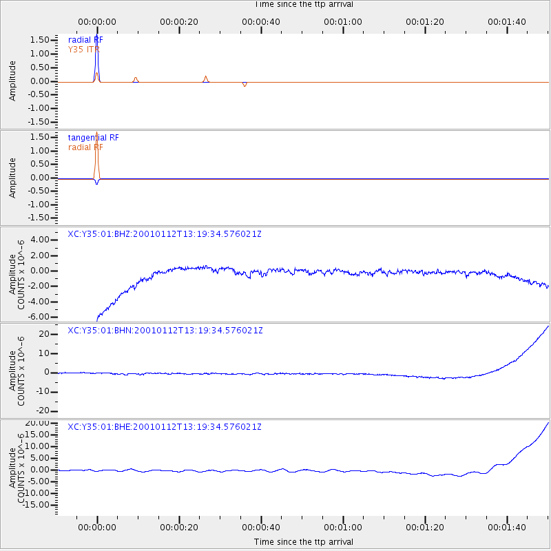
Signal To Noise
| Channel | StoN | STA | LTA |
| XC:Y35:01:BHN:20010112T13:19:34.576021Z | 0.88434625 | 1.779635E-6 | 2.0123737E-6 |
| XC:Y35:01:BHE:20010112T13:19:34.576021Z | 0.90859854 | 1.2169141E-6 | 1.339331E-6 |
| XC:Y35:01:BHZ:20010112T13:19:34.576021Z | 0.8856426 | 1.798812E-6 | 2.0310813E-6 |
| Arrivals |
| Ps | 1.0 SECOND |
| PpPs | 4.1 SECOND |
| PsPs/PpSs | 5.1 SECOND |


