You are here: Home > Network List > XC00 - Yellowstone Intermountain Seismic Array Stations List
> Station Y35 Y35 > Earthquake Result Viewer
Y35 Y35 - Earthquake Result Viewer
| Earthquake location: |
Fiji Islands Region |
| Earthquake latitude/longitude: |
-18.1/-176.9 |
| Earthquake time(UTC): |
2001/04/28 (118) 04:49:53 GMT |
| Earthquake Depth: |
352 km |
| Earthquake Magnitude: |
6.2 MB, 6.8 MW, 6.8 MW |
| Earthquake Catalog/Contributor: |
WHDF/NEIC |
|
| Network: |
XC Yellowstone Intermountain Seismic Array |
| Station: |
Y35 Y35 |
| Lat/Lon: |
42.57 N/108.04 W |
| Elevation: |
2062 m |
|
| Distance: |
87.4 deg |
| Az: |
43.622 deg |
| Baz: |
242.677 deg |
| Ray Param: |
0.042453527 |
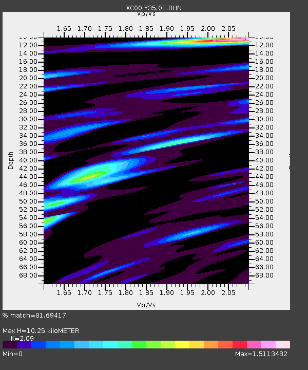
| Estimated Moho Depth: |
10.25 km |
| Estimated Crust Vp/Vs: |
2.09 |
| Assumed Crust Vp: |
6.161 km/s |
| Estimated Crust Vs: |
2.948 km/s |
| Estimated Crust Poisson's Ratio: |
0.35 |
|
| Radial Match: |
81.69417 % |
| Radial Bump: |
400 |
| Transverse Match: |
64.4069 % |
| Transverse Bump: |
400 |
| SOD ConfigId: |
4714 |
| Insert Time: |
2010-02-26 14:57:24.238 +0000 |
| GWidth: |
2.5 |
| Max Bumps: |
400 |
| Tol: |
0.001 |
|
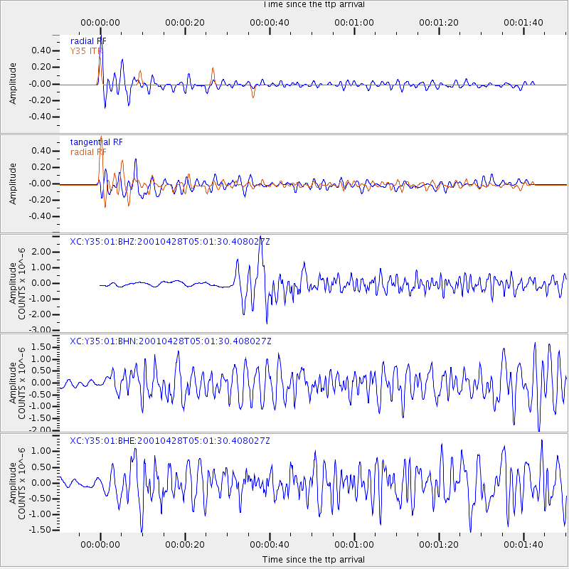
Signal To Noise
| Channel | StoN | STA | LTA |
| XC:Y35:01:BHN:20010428T05:01:30.408027Z | 2.8096025 | 3.237899E-7 | 1.1524402E-7 |
| XC:Y35:01:BHE:20010428T05:01:30.408027Z | 2.7503474 | 3.7263462E-7 | 1.3548639E-7 |
| XC:Y35:01:BHZ:20010428T05:01:30.408027Z | 7.2403226 | 8.27202E-7 | 1.14249325E-7 |
| Arrivals |
| Ps | 1.8 SECOND |
| PpPs | 5.1 SECOND |
| PsPs/PpSs | 6.9 SECOND |


