You are here: Home > Network List > SP - South Carolina Earth Physics Project Stations List
> Station BBLV Batesburg-Leesville High School, Lexington County, SC USA > Earthquake Result Viewer
BBLV Batesburg-Leesville High School, Lexington County, SC USA - Earthquake Result Viewer
| Earthquake location: |
Near East Coast Of Honshu, Japan |
| Earthquake latitude/longitude: |
38.8/141.6 |
| Earthquake time(UTC): |
2003/05/26 (146) 09:24:33 GMT |
| Earthquake Depth: |
68 km |
| Earthquake Magnitude: |
6.7 MB, 7.0 MW, 7.0 MW |
| Earthquake Catalog/Contributor: |
WHDF/NEIC |
|
| Network: |
SP South Carolina Earth Physics Project |
| Station: |
BBLV Batesburg-Leesville High School, Lexington County, SC USA |
| Lat/Lon: |
33.92 N/81.53 W |
| Elevation: |
198 m |
|
| Distance: |
97.3 deg |
| Az: |
34.947 deg |
| Baz: |
327.458 deg |
| Ray Param: |
0.040207576 |
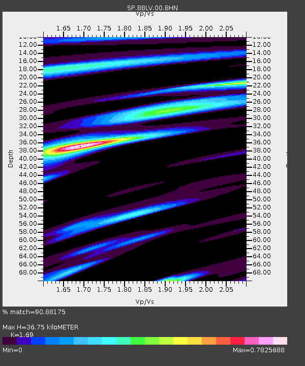
| Estimated Moho Depth: |
36.75 km |
| Estimated Crust Vp/Vs: |
1.69 |
| Assumed Crust Vp: |
6.565 km/s |
| Estimated Crust Vs: |
3.884 km/s |
| Estimated Crust Poisson's Ratio: |
0.23 |
|
| Radial Match: |
90.88175 % |
| Radial Bump: |
400 |
| Transverse Match: |
81.50002 % |
| Transverse Bump: |
400 |
| SOD ConfigId: |
2186 |
| Insert Time: |
2010-02-25 16:35:25.907 +0000 |
| GWidth: |
2.5 |
| Max Bumps: |
400 |
| Tol: |
0.001 |
|

Signal To Noise
| Channel | StoN | STA | LTA |
| SP:BBLV:00:BHN:20030526T09:37:27.488013Z | 2.1980553 | 2.1640406E-7 | 9.845251E-8 |
| SP:BBLV:00:BHE:20030526T09:37:27.488013Z | 1.3012569 | 1.4442558E-7 | 1.1098929E-7 |
| SP:BBLV:00:BHZ:20030526T09:37:27.488013Z | 5.7397118 | 3.4691487E-7 | 6.0441174E-8 |
| Arrivals |
| Ps | 3.9 SECOND |
| PpPs | 15 SECOND |
| PsPs/PpSs | 19 SECOND |


