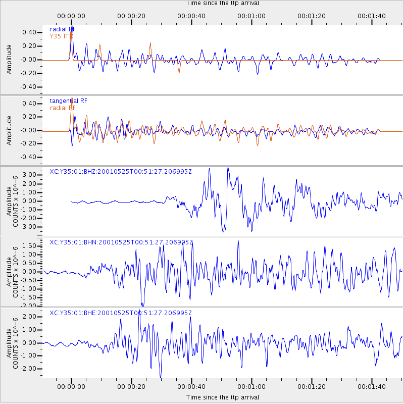
Y35 Y35 - Earthquake Result Viewer
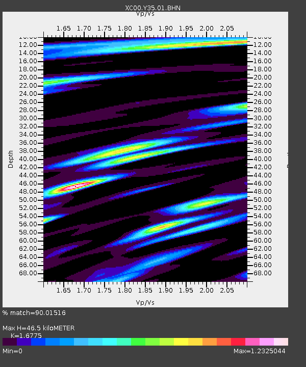
Earthquake location: Kuril Islands
Earthquake latitude/longitude: 44.3/148.4
Earthquake time(UTC): 2001/05/25 (145) 00:40:50 GMT
Earthquake Depth: 33 km
Earthquake Magnitude: 6.1 MB, 6.7 MS, 6.7 MW, 6.6 MW
Earthquake Catalog/Contributor: WHDF/NEIC
Network: XC Yellowstone Intermountain Seismic Array
Station: Y35 Y35
Lat/Lon: 42.57 N/108.04 W
Elevation: 2062 m
Distance: 69.9 deg
Az: 49.897 deg
Baz: 311.938 deg
Ray Param: 0.0553168
Estimated Moho Depth: 46.5 km
Estimated Crust Vp/Vs: 1.68
Assumed Crust Vp: 6.161 km/s
Estimated Crust Vs: 3.673 km/s
Estimated Crust Poisson's Ratio: 0.22
Radial Match: 90.01516 %
Radial Bump: 400
Transverse Match: 85.73581 %
Transverse Bump: 400
SOD ConfigId: 4714
Insert Time: 2010-02-26 14:57:25.061 +0000
GWidth: 2.5
Max Bumps: 400
Tol: 0.001

Signal To Noise

ChannelStoNSTALTA
XC:Y35:01:BHN:20010525T00:51:27.206995Z2.17283031.3243755E-76.095163E-8
XC:Y35:01:BHE:20010525T00:51:27.206995Z1.31872321.2264789E-79.300502E-8
XC:Y35:01:BHZ:20010525T00:51:27.206995Z4.4239023.7159677E-78.399751E-8
Arrivals
Ps5.3 SECOND
PpPs19 SECOND
PsPs/PpSs25 SECOND