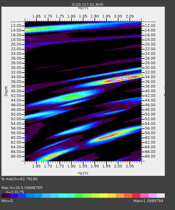
Y17 Y17 - Earthquake Result Viewer
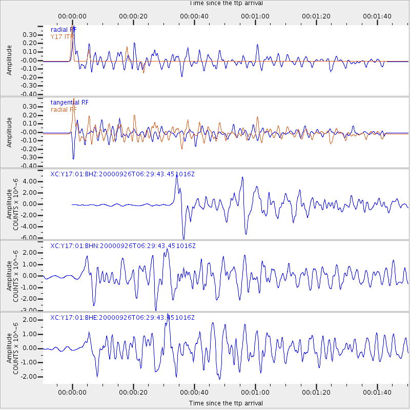
Earthquake location: Tonga Islands
Earthquake latitude/longitude: -17.2/-173.9
Earthquake time(UTC): 2000/09/26 (270) 06:17:52 GMT
Earthquake Depth: 56 km
Earthquake Magnitude: 6.1 MB, 6.1 MS, 6.4 MW, 6.1 ME
Earthquake Catalog/Contributor: WHDF/NEIC
Network: XC Yellowstone Intermountain Seismic Array
Station: Y17 Y17
Lat/Lon: 44.10 N/111.19 W
Elevation: 1762 m
Distance: 83.6 deg
Az: 40.129 deg
Baz: 238.777 deg
Ray Param: 0.04598794
Estimated Moho Depth: 34.5 km
Estimated Crust Vp/Vs: 2.02
Assumed Crust Vp: 6.35 km/s
Estimated Crust Vs: 3.147 km/s
Estimated Crust Poisson's Ratio: 0.34
Radial Match: 92.79198 %
Radial Bump: 400
Transverse Match: 89.79521 %
Transverse Bump: 400
SOD ConfigId: 16820
Insert Time: 2010-02-26 14:57:33.817 +0000
GWidth: 2.5
Max Bumps: 400
Tol: 0.001

Signal To Noise

ChannelStoNSTALTA
XC:Y17:01:BHN:20000926T06:29:43.451016Z3.04726395.6926746E-71.8681264E-7
XC:Y17:01:BHE:20000926T06:29:43.451016Z2.32021382.2088769E-79.5201436E-8
XC:Y17:01:BHZ:20000926T06:29:43.451016Z19.1123121.8533755E-69.6972855E-8
Arrivals
Ps5.6 SECOND
PpPs16 SECOND
PsPs/PpSs22 SECOND