
Station XC Y17 - Y17
Network: XC00 - Yellowstone Intermountain Seismic Array
Nearby stations (2 deg radius)
| Station | Name | (Lat, Lon) | Start / End | Elevation |
| Y17 | Y17 | (44.10, -111.19) | 2000-06-27 / 2001-12-31 | 1762 m |
| Crust2 Type: | P6,orogen/43km, Orogen, 0.5 km seds. |
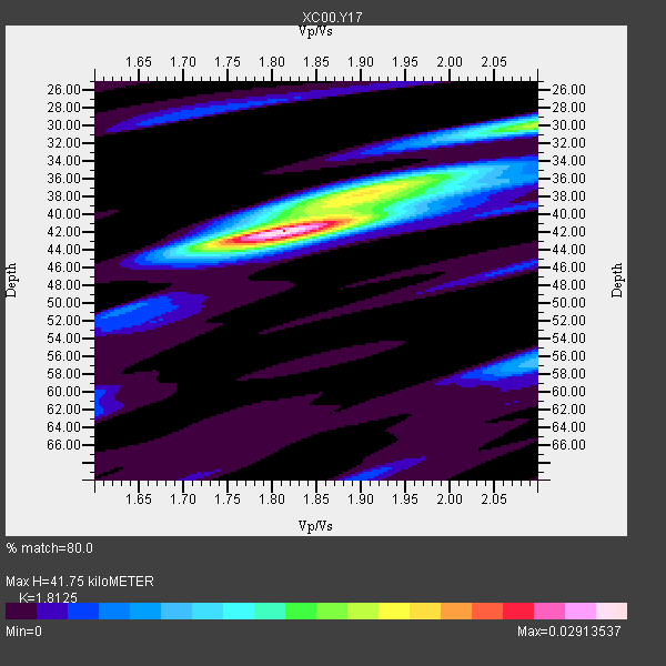
| Thickness Estimate: | 42 km |
| Thickness StdDev: | 4.9 km |
| Vp/Vs Estimate: | 1.81 |
| Vp/Vs StdDev: | 0.10 |
| Vs Estimate: | 3.503 km/s |
| Poisson's Ratio: | 0.28 |
| Peak Value: | 0.03 |
| Assumed Vp: | 6.35 km/s |
| Ps Weight: | 0.33333334 |
| PpPs Weight: | 0.33333334 |
| PsPs Weight: | 0.33333328 |
| Residual Complexity: | 0.548 |
| Nearby stations H: | +- |
| (2.0 deg) Vp/Vs: | +- |
6 with match > 90% ( 42.857143 %) and 14 with match > 80% ( 100.0 %) out of 14.
Download stack as xyz text file.
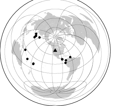
Azimuth Distribution of Events:
Prior Results for this Station
| Study | Thickness | Vp/Vs | Vp | Vs | Poissons Ratio | Extra |
| EARS | 42 km | 1.81 | 6.35 km/s | 3.503 km/s | 0.28 | |
| Crust2.0 | 43 km | 1.76 | 6.35 km/s | 3.609 km/s | 0.26 | P6,orogen/43km, Orogen, 0.5 km seds. |
| Global Maxima | 42 km | 1.81 | 6.35 km/s | 3.503 km/s | 0.28 | amp=0.02913537 |
| Local Maxima 1 | 30 km | 2.10 | 6.35 km/s | 3.027 km/s | 0.35 | amp=0.016412603 |
| Local Maxima 2 | 38 km | 1.91 | 6.35 km/s | 3.329 km/s | 0.31 | amp=0.014315425 |
| Local Maxima 3 | 57 km | 2.10 | 6.35 km/s | 3.027 km/s | 0.35 | amp=0.008633691 |
| Local Maxima 4 | 36 km | 1.98 | 6.35 km/s | 3.203 km/s | 0.33 | amp=0.008517603 |
| Predicted Arrivals for vertical incidence (zero ray parameter) | |
| Ps | 5.34 SECOND |
| PpPs | 18.49 SECOND |
| PsPs/PpSs | 23.83 SECOND |
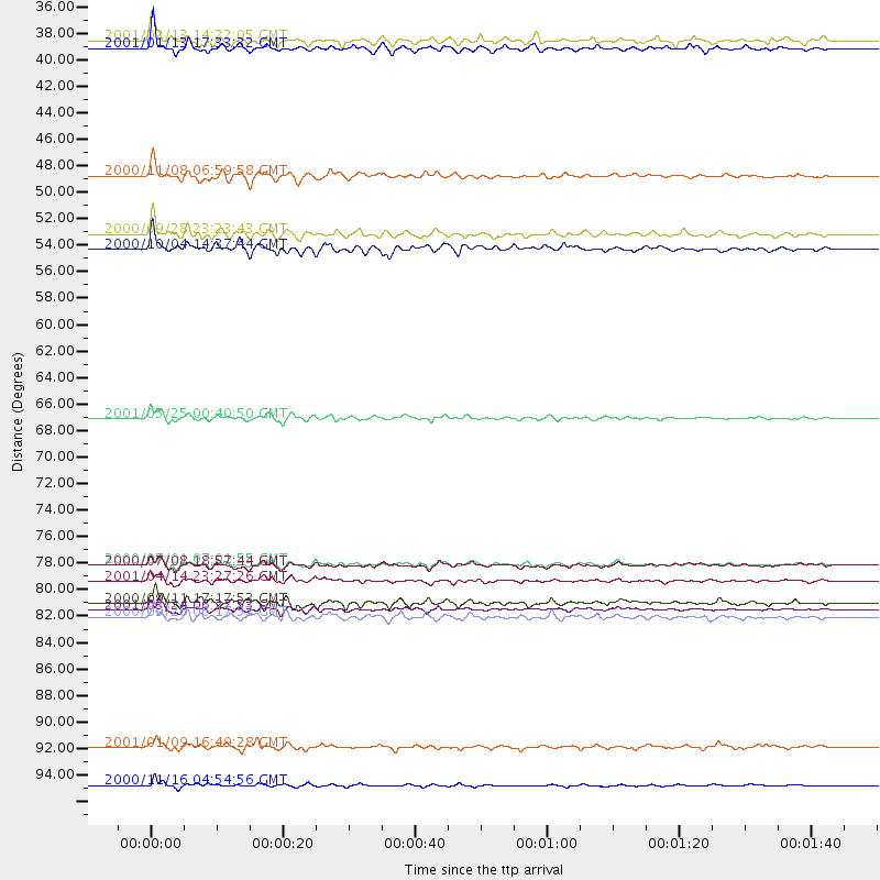
Events Processed for this Station
Download zip of receiver functions as SAC
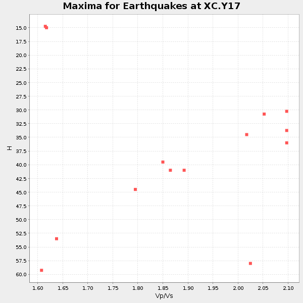
Plot maxima for each earthquake.
Events Used in the Stack
(14 events)| Radial Match | Distance | Baz | FERegion | Time | Lat/Lon | Depth | Magnitude |
| 95.47915 | 67.1 deg | 309.924 deg | Kuril Islands | 2001/05/25 00:40:50 GMT | (44.3, 148.4) | 33 km | 6.1 MB, 6.7 MS, 6.7 MW, 6.6 MW |
| 94.647804 | 83.0 deg | 311.433 deg | Western Honshu, Japan | 2001/03/24 06:27:53 GMT | (34.1, 132.5) | 50 km | 6.4 MB, 6.5 MS, 6.8 MW, 6.4 ME |
| 93.55184 | 79.2 deg | 307.416 deg | Near S. Coast Of Honshu, Japan | 2000/07/01 07:01:55 GMT | (34.2, 139.1) | 10 km | 6.0 MB, 6.1 MS, 6.2 MW, 6.2 MW |
| 93.47775 | 36.5 deg | 141.094 deg | El Salvador | 2001/01/13 17:33:32 GMT | (13.0, -88.7) | 60 km | 6.4 MB, 7.8 MS, 7.7 MW, 7.5 ME |
| 92.79198 | 83.6 deg | 238.777 deg | Tonga Islands | 2000/09/26 06:17:52 GMT | (-17.2, -173.9) | 56 km | 6.1 MB, 6.1 MS, 6.4 MW, 6.1 ME |
| 90.11078 | 80.6 deg | 302.878 deg | Southeast Of Honshu, Japan | 2001/04/14 23:27:26 GMT | (30.1, 141.8) | 10 km | 6.0 MB, 5.8 MS, 6.0 MW, 6.0 ME |
| 87.47651 | 53.1 deg | 112.942 deg | Windward Islands | 2000/10/04 14:37:44 GMT | (11.1, -62.6) | 110 km | 5.6 MB, 5.4 MS, 6.1 MW, 5.9 MD |
| 87.22823 | 82.4 deg | 239.443 deg | Tonga Islands | 2000/09/11 17:17:53 GMT | (-15.9, -173.7) | 115 km | 6.0 MB, 6.3 MW, 6.3 MW |
| 87.20108 | 79.3 deg | 307.302 deg | Near S. Coast Of Honshu, Japan | 2000/07/08 18:57:44 GMT | (34.1, 139.1) | 10 km | 5.9 MB, 5.6 MS, 6.0 MW, 5.9 MW |
| 87.12136 | 47.0 deg | 131.753 deg | Panama-Colombia Border Region | 2000/11/08 06:59:58 GMT | (7.0, -77.8) | 17 km | 6.0 MB, 6.4 MS, 6.5 MW, 6.2 ML |
| 87.0383 | 35.8 deg | 141.013 deg | El Salvador | 2001/02/13 14:22:05 GMT | (13.7, -88.9) | 10 km | 5.5 MB, 6.5 MS, 6.6 MW, 6.1 MD |
| 85.510666 | 97.5 deg | 271.756 deg | New Ireland Region, P.N.G. | 2000/11/16 04:54:56 GMT | (-4.0, 152.2) | 33 km | 6.0 MB, 8.2 MS, 8.0 MW, 8.0 ME |
| 84.296814 | 51.9 deg | 139.664 deg | Near Coast Of Ecuador | 2000/09/28 23:23:43 GMT | (-0.2, -80.6) | 23 km | 5.8 MB, 6.0 MS, 6.6 MW, 6.4 MW |
| 80.108574 | 94.4 deg | 253.579 deg | Vanuatu Islands | 2001/01/09 16:49:28 GMT | (-14.9, 167.2) | 103 km | 6.3 MB, 6.6 MS, 7.6 ME, 7.0 MW |
Losers
(0 events)| Radial Match | Distance | Baz | FERegion | Time | Lat/Lon | Depth | Magnitude | Reason |
