You are here: Home > Network List > XC00 - Yellowstone Intermountain Seismic Array Stations List
> Station Y17 Y17 > Earthquake Result Viewer
Y17 Y17 - Earthquake Result Viewer
| Earthquake location: |
Tonga Islands |
| Earthquake latitude/longitude: |
-15.9/-173.7 |
| Earthquake time(UTC): |
2000/09/11 (255) 17:17:53 GMT |
| Earthquake Depth: |
115 km |
| Earthquake Magnitude: |
6.0 MB, 6.3 MW, 6.3 MW |
| Earthquake Catalog/Contributor: |
WHDF/NEIC |
|
| Network: |
XC Yellowstone Intermountain Seismic Array |
| Station: |
Y17 Y17 |
| Lat/Lon: |
44.10 N/111.19 W |
| Elevation: |
1762 m |
|
| Distance: |
82.4 deg |
| Az: |
40.144 deg |
| Baz: |
239.443 deg |
| Ray Param: |
0.046629462 |
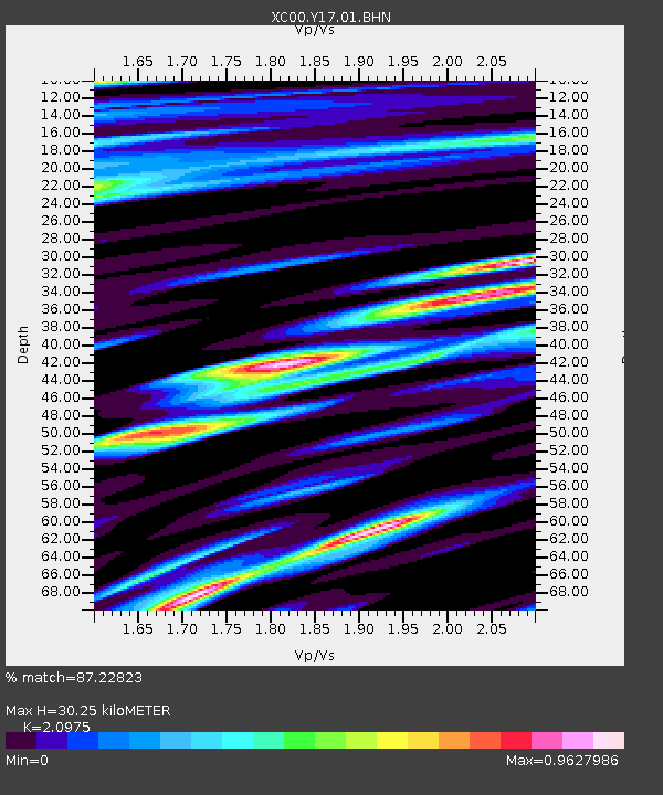
| Estimated Moho Depth: |
30.25 km |
| Estimated Crust Vp/Vs: |
2.10 |
| Assumed Crust Vp: |
6.35 km/s |
| Estimated Crust Vs: |
3.027 km/s |
| Estimated Crust Poisson's Ratio: |
0.35 |
|
| Radial Match: |
87.22823 % |
| Radial Bump: |
400 |
| Transverse Match: |
82.81391 % |
| Transverse Bump: |
400 |
| SOD ConfigId: |
16820 |
| Insert Time: |
2010-02-26 14:57:34.605 +0000 |
| GWidth: |
2.5 |
| Max Bumps: |
400 |
| Tol: |
0.001 |
|
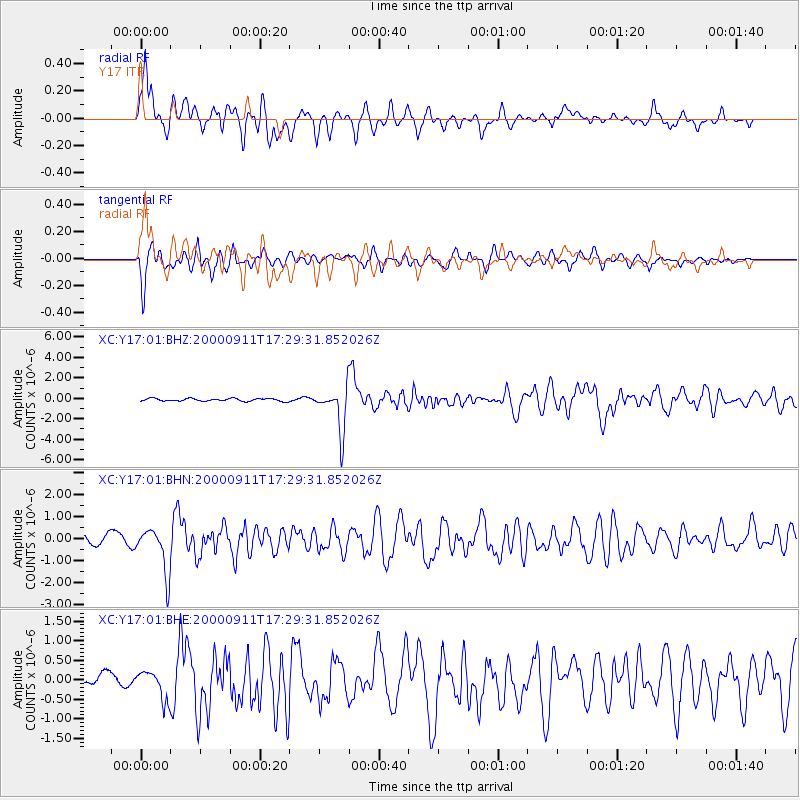
Signal To Noise
| Channel | StoN | STA | LTA |
| XC:Y17:01:BHN:20000911T17:29:31.852026Z | 4.160859 | 1.0310393E-6 | 2.4779484E-7 |
| XC:Y17:01:BHE:20000911T17:29:31.852026Z | 1.9790226 | 3.6445778E-7 | 1.841605E-7 |
| XC:Y17:01:BHZ:20000911T17:29:31.852026Z | 16.421114 | 2.1306166E-6 | 1.2974861E-7 |
| Arrivals |
| Ps | 5.3 SECOND |
| PpPs | 14 SECOND |
| PsPs/PpSs | 20 SECOND |


