You are here: Home > Network List > XD94 - Tanzania BB Experiment Stations List
> Station AMBA XD.AMBA > Earthquake Result Viewer
AMBA XD.AMBA - Earthquake Result Viewer
| Earthquake location: |
Mindoro, Philippines |
| Earthquake latitude/longitude: |
13.5/121.1 |
| Earthquake time(UTC): |
1994/11/14 (318) 19:15:30 GMT |
| Earthquake Depth: |
33 km |
| Earthquake Magnitude: |
6.1 MB, 7.1 MS, 7.1 UNKNOWN, 7.1 MW |
| Earthquake Catalog/Contributor: |
WHDF/NEIC |
|
| Network: |
XD Tanzania BB Experiment |
| Station: |
AMBA XD.AMBA |
| Lat/Lon: |
8.11 S/33.26 E |
| Elevation: |
1415 m |
|
| Distance: |
89.8 deg |
| Az: |
261.665 deg |
| Baz: |
76.386 deg |
| Ray Param: |
0.041716676 |
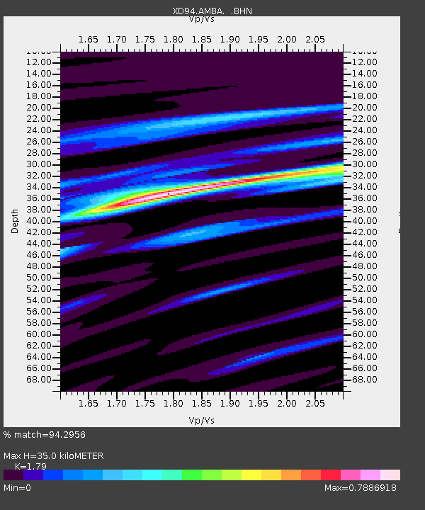
| Estimated Moho Depth: |
35.0 km |
| Estimated Crust Vp/Vs: |
1.79 |
| Assumed Crust Vp: |
6.502 km/s |
| Estimated Crust Vs: |
3.632 km/s |
| Estimated Crust Poisson's Ratio: |
0.27 |
|
| Radial Match: |
94.2956 % |
| Radial Bump: |
400 |
| Transverse Match: |
80.00005 % |
| Transverse Bump: |
400 |
| SOD ConfigId: |
16938 |
| Insert Time: |
2010-03-08 22:46:53.721 +0000 |
| GWidth: |
2.5 |
| Max Bumps: |
400 |
| Tol: |
0.001 |
|
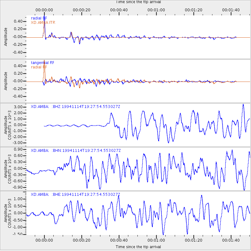
Signal To Noise
| Channel | StoN | STA | LTA |
| XD:AMBA: :BHN:19941114T19:27:54.553027Z | 0.8618655 | 114.45449 | 132.79855 |
| XD:AMBA: :BHE:19941114T19:27:54.553027Z | 0.83152795 | 86.93279 | 104.545845 |
| XD:AMBA: :BHZ:19941114T19:27:54.553027Z | 2.166101 | 203.21503 | 93.81605 |
| Arrivals |
| Ps | 4.3 SECOND |
| PpPs | 15 SECOND |
| PsPs/PpSs | 19 SECOND |


