
Station XD AMBA - XD.AMBA
Network: XD94 - Tanzania BB Experiment
Nearby stations (2 deg radius)
| Station | Name | (Lat, Lon) | Start / End | Elevation |
| AMBA | XD.AMBA | (-8.11, 33.26) | 1994-10-31 / 1995-05-16 | 1415 m |
| Crust2 Type: | X2,Rift, Rio Grande, Baikal, 0.5km sediments |
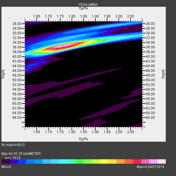
| Thickness Estimate: | 35 km |
| Thickness StdDev: | 0.5 km |
| Vp/Vs Estimate: | 1.76 |
| Vp/Vs StdDev: | 0.02 |
| Vs Estimate: | 3.689 km/s |
| Poisson's Ratio: | 0.26 |
| Peak Value: | 0.05 |
| Assumed Vp: | 6.502 km/s |
| Ps Weight: | 0.33333334 |
| PpPs Weight: | 0.33333334 |
| PsPs Weight: | 0.33333328 |
| Residual Complexity: | 0.426 |
| Nearby stations H: | +- |
| (2.0 deg) Vp/Vs: | +- |
8 with match > 90% ( 33.333332 %) and 12 with match > 80% ( 50.0 %) out of 24.
Download stack as xyz text file.
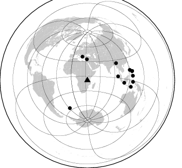
Azimuth Distribution of Events:
Prior Results for this Station
| Study | Thickness | Vp/Vs | Vp | Vs | Poissons Ratio | Extra |
| EARS | 35 km | 1.76 | 6.502 km/s | 3.689 km/s | 0.26 | |
| Crust2.0 | 33 km | 1.77 | 6.502 km/s | 3.68 km/s | 0.26 | X2,Rift, Rio Grande, Baikal, 0.5km sediments |
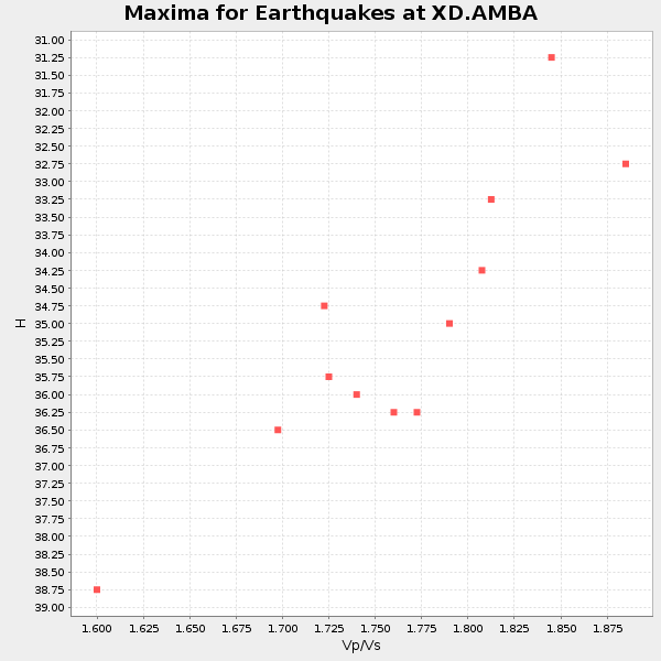
| Global Maxima | 35 km | 1.76 | 6.502 km/s | 3.689 km/s | 0.26 | amp=0.04572974 |
| Local Maxima 1 | 37 km | 1.75 | 6.502 km/s | 3.71 km/s | 0.26 | amp=0.02200419 |
| Local Maxima 2 | 27 km | 1.95 | 6.502 km/s | 3.343 km/s | 0.32 | amp=0.011889598 |
| Local Maxima 3 | 31 km | 2.06 | 6.502 km/s | 3.152 km/s | 0.35 | amp=0.011285945 |
| Local Maxima 4 | 34 km | 1.68 | 6.502 km/s | 3.87 km/s | 0.23 | amp=0.0081766285 |
| Predicted Arrivals for vertical incidence (zero ray parameter) | |
| Ps | 4.13 SECOND |
| PpPs | 14.98 SECOND |
| PsPs/PpSs | 19.11 SECOND |
Events Processed for this Station
Download zip of receiver functions as SAC
Plot maxima for each earthquake.
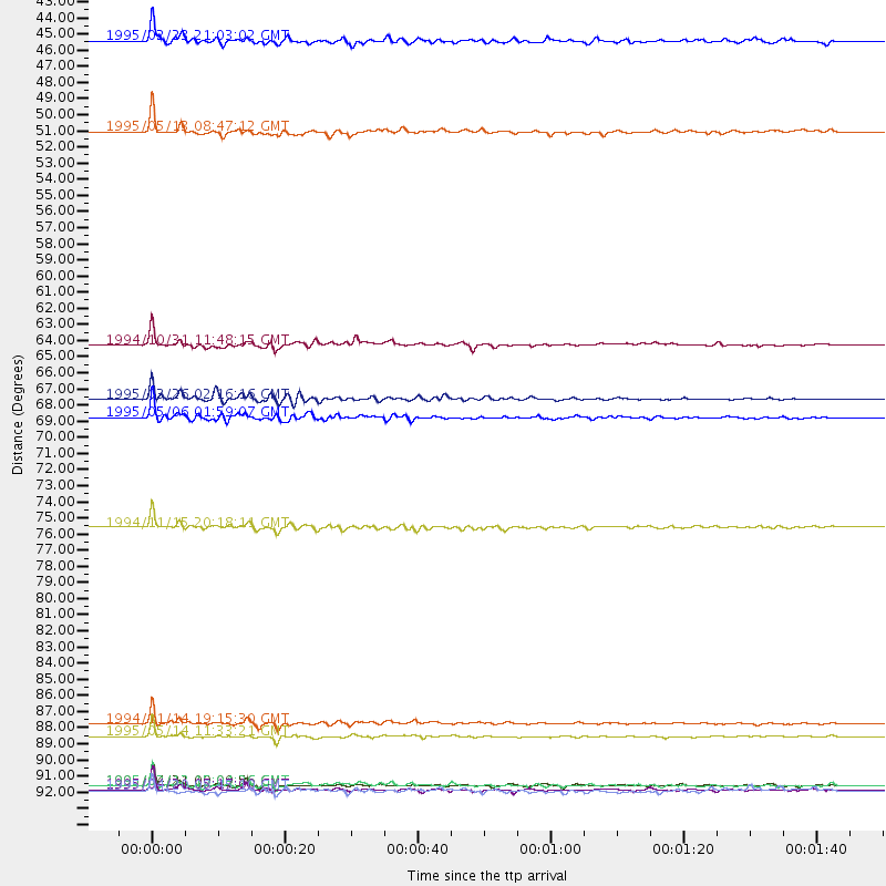
Events Used in the Stack
(12 events)| Radial Match | Distance | Baz | FERegion | Time | Lat/Lon | Depth | Magnitude |
| 96.71355 | 90.6 deg | 98.514 deg | Timor Region | 1995/05/14 11:33:21 GMT | (-8.4, 125.1) | 33 km | 6.1 MB, 6.9 MS, 7.1 UNKNOWN, 6.9 MW |
| 95.209785 | 94.0 deg | 78.511 deg | Samar, Philippines | 1995/04/21 00:09:56 GMT | (12.0, 125.7) | 33 km | 6.1 MB, 6.9 MS, 6.9 UNKNOWN, 6.8 MW |
| 95.18204 | 67.5 deg | 212.42 deg | South Sandwich Islands Region | 1995/03/26 02:16:16 GMT | (-55.9, -28.2) | 77 km | 6.1 MB, 5.9 MS, 6.4 UNKNOWN, 6.3 MW |
| 94.86433 | 68.8 deg | 59.313 deg | Myanmar-India Border Region | 1995/05/06 01:59:07 GMT | (25.0, 95.3) | 122 km | 6.4 MB, 6.5 UNKNOWN, 6.4 MW |
| 94.2956 | 89.8 deg | 76.386 deg | Mindoro, Philippines | 1994/11/14 19:15:30 GMT | (13.5, 121.1) | 33 km | 6.1 MB, 7.1 MS, 7.1 UNKNOWN, 7.1 MW |
| 93.70727 | 76.3 deg | 93.811 deg | Java Sea | 1994/11/15 20:18:11 GMT | (-5.6, 110.2) | 559 km | 6.2 MB, 6.5 UNKNOWN, 6.5 MW |
| 92.572685 | 49.2 deg | 348.274 deg | Greece | 1995/05/13 08:47:12 GMT | (40.1, 21.7) | 13 km | 6.2 MB, 6.5 MS, 6.6 UNKNOWN, 6.5 MD |
| 90.089584 | 94.3 deg | 78.401 deg | Samar, Philippines | 1995/04/21 05:17:00 GMT | (12.1, 125.9) | 23 km | 5.6 MB, 6.9 MS, 6.7 UNKNOWN, 6.7 MW |
| 89.87744 | 94.0 deg | 91.93 deg | Halmahera, Indonesia | 1995/02/13 15:04:26 GMT | (-1.4, 127.5) | 33 km | 6.2 MB, 6.8 MS, 6.8 UNKNOWN, 6.7 MW |
| 85.744835 | 63.8 deg | 82.603 deg | Northern Sumatra, Indonesia | 1994/10/31 11:48:15 GMT | (3.0, 96.3) | 46 km | 5.6 MB, 6.1 MS, 6.3 UNKNOWN, 6.2 MW |
| 85.64348 | 94.4 deg | 84.298 deg | Mindanao, Philippines | 1995/04/20 08:45:10 GMT | (6.3, 126.8) | 85 km | 6.2 MB, 6.6 UNKNOWN, 6.5 MW |
| 81.05244 | 42.9 deg | 358.804 deg | Cyprus Region | 1995/02/23 21:03:02 GMT | (35.0, 32.3) | 15 km | 5.8 MB, 5.7 MS, 5.9 UNKNOWN, 5.8 MW |
Losers
(12 events)| Radial Match | Distance | Baz | FERegion | Time | Lat/Lon | Depth | Magnitude | Reason |
| 75.55333 | 96.8 deg | 245.375 deg | Chile-Argentina Border Region | 1995/02/14 15:53:56 GMT | (-23.3, -67.7) | 156 km | 5.7 MB, 6.0 UNKNOWN, 6.0 MW | |
| 71.81148 | 93.9 deg | 91.871 deg | Halmahera, Indonesia | 1995/02/13 08:43:39 GMT | (-1.3, 127.4) | 33 km | 6.1 MB, 6.2 MS, 6.2 UNKNOWN, 6.2 MW | |
| 71.56093 | 79.7 deg | 306.433 deg | Northern Mid-Atlantic Ridge | 1995/04/17 07:14:35 GMT | (33.8, -38.6) | 10 km | 5.8 MB, 5.8 MS, 5.9 UNKNOWN, 6.1 MW | |
| 71.05275 | 94.2 deg | 78.963 deg | Samar, Philippines | 1995/05/08 18:08:09 GMT | (11.6, 125.9) | 33 km | 5.6 MB, 6.2 MS, 6.3 UNKNOWN, 6.3 MW | |
| 65.52149 | 93.6 deg | 85.285 deg | Mindanao, Philippines | 1995/02/19 00:17:48 GMT | (5.2, 126.2) | 104 km | 5.9 MB, 6.1 UNKNOWN, 6.1 MW | |
| 65.06967 | 75.1 deg | 93.253 deg | Java Sea | 1995/05/13 21:00:54 GMT | (-5.2, 108.9) | 554 km | 5.7 MB, 5.9 UNKNOWN, 5.8 MW | |
| 59.909634 | 85.4 deg | 86.666 deg | Celebes Sea | 1995/03/06 18:43:42 GMT | (2.7, 118.2) | 33 km | 5.5 MB, 5.8 MS, 6.3 UNKNOWN, 6.1 MW | |
| 58.106514 | 94.5 deg | 84.449 deg | Mindanao, Philippines | 1995/04/04 17:21:04 GMT | (6.2, 127.0) | 86 km | 5.5 MB | |
| 54.855896 | 95.4 deg | 88.9 deg | Halmahera, Indonesia | 1995/05/04 02:18:51 GMT | (1.9, 128.5) | 55 km | 6.0 MB, 6.0 MS, 6.1 UNKNOWN, 6.1 MW | |
| 50.443417 | 94.3 deg | 78.785 deg | Philippine Islands Region | 1995/04/29 09:44:00 GMT | (11.8, 126.0) | 33 km | 5.4 MB, 6.0 MS, 6.1 UNKNOWN, 6.0 MW | |
| 49.855812 | 65.5 deg | 205.674 deg | Southwestern Atlantic Ocean | 1995/04/14 13:15:16 GMT | (-60.7, -20.0) | 10 km | 5.4 MB, 5.9 MS, 6.5 UNKNOWN, 6.3 MW | |
| 36.940712 | 70.9 deg | 40.831 deg | Southern Xinjiang, China | 1995/05/15 04:05:58 GMT | (41.7, 88.8) | 0.0 km | 6.1 MB |
