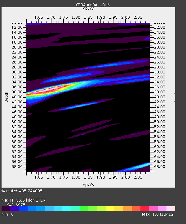
AMBA XD.AMBA - Earthquake Result Viewer
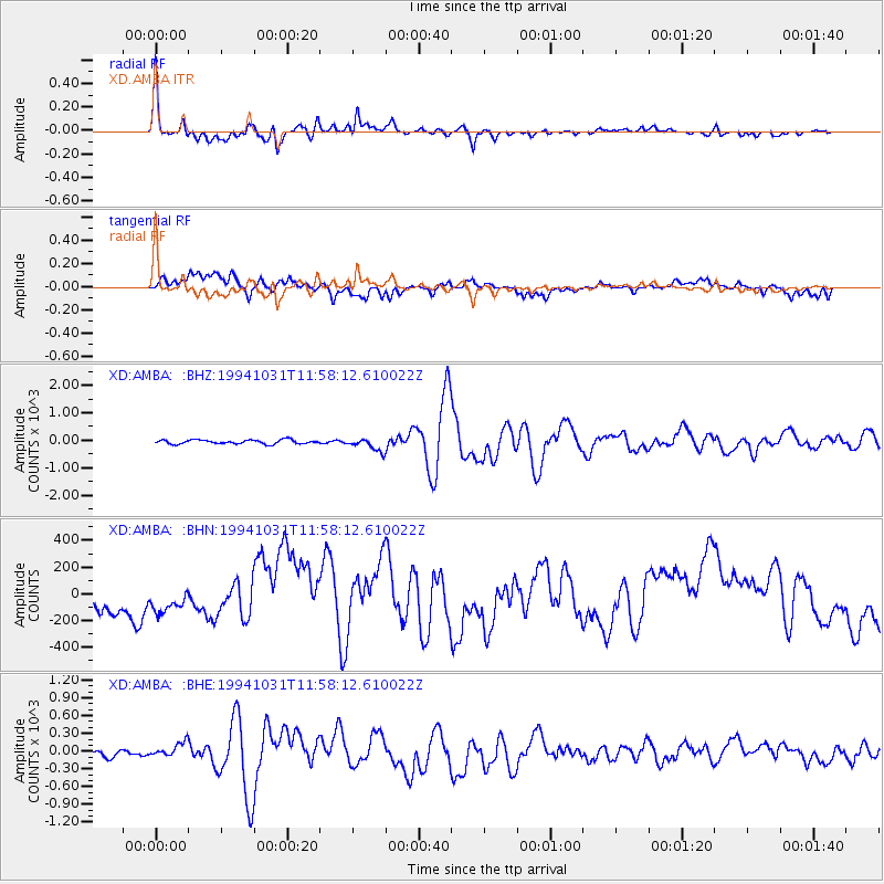
Earthquake location: Northern Sumatra, Indonesia
Earthquake latitude/longitude: 3.0/96.3
Earthquake time(UTC): 1994/10/31 (304) 11:48:15 GMT
Earthquake Depth: 46 km
Earthquake Magnitude: 5.6 MB, 6.1 MS, 6.3 UNKNOWN, 6.2 MW
Earthquake Catalog/Contributor: WHDF/NEIC
Network: XD Tanzania BB Experiment
Station: AMBA XD.AMBA
Lat/Lon: 8.11 S/33.26 E
Elevation: 1415 m
Distance: 63.8 deg
Az: 259.501 deg
Baz: 82.603 deg
Ray Param: 0.059240993
Estimated Moho Depth: 36.5 km
Estimated Crust Vp/Vs: 1.70
Assumed Crust Vp: 6.502 km/s
Estimated Crust Vs: 3.83 km/s
Estimated Crust Poisson's Ratio: 0.23
Radial Match: 85.744835 %
Radial Bump: 400
Transverse Match: 61.51166 %
Transverse Bump: 400
SOD ConfigId: 17000
Insert Time: 2010-03-08 22:46:56.879 +0000
GWidth: 2.5
Max Bumps: 400
Tol: 0.001

Signal To Noise

ChannelStoNSTALTA
XD:AMBA: :BHN:19941031T11:58:12.610022Z0.4250947870.37903165.56079
XD:AMBA: :BHE:19941031T11:58:12.610022Z2.038389175.5586586.126175
XD:AMBA: :BHZ:19941031T11:58:12.610022Z3.2028213235.789473.619286
Arrivals
Ps4.1 SECOND
PpPs14 SECOND
PsPs/PpSs19 SECOND