You are here: Home > Network List > XD94 - Tanzania BB Experiment Stations List
> Station AMBA XD.AMBA > Earthquake Result Viewer
AMBA XD.AMBA - Earthquake Result Viewer
| Earthquake location: |
Samar, Philippines |
| Earthquake latitude/longitude: |
12.0/125.7 |
| Earthquake time(UTC): |
1995/04/21 (111) 00:09:56 GMT |
| Earthquake Depth: |
33 km |
| Earthquake Magnitude: |
6.1 MB, 6.9 MS, 6.9 UNKNOWN, 6.8 MW |
| Earthquake Catalog/Contributor: |
WHDF/NEIC |
|
| Network: |
XD Tanzania BB Experiment |
| Station: |
AMBA XD.AMBA |
| Lat/Lon: |
8.11 S/33.26 E |
| Elevation: |
1415 m |
|
| Distance: |
94.0 deg |
| Az: |
262.607 deg |
| Baz: |
78.511 deg |
| Ray Param: |
0.041127454 |
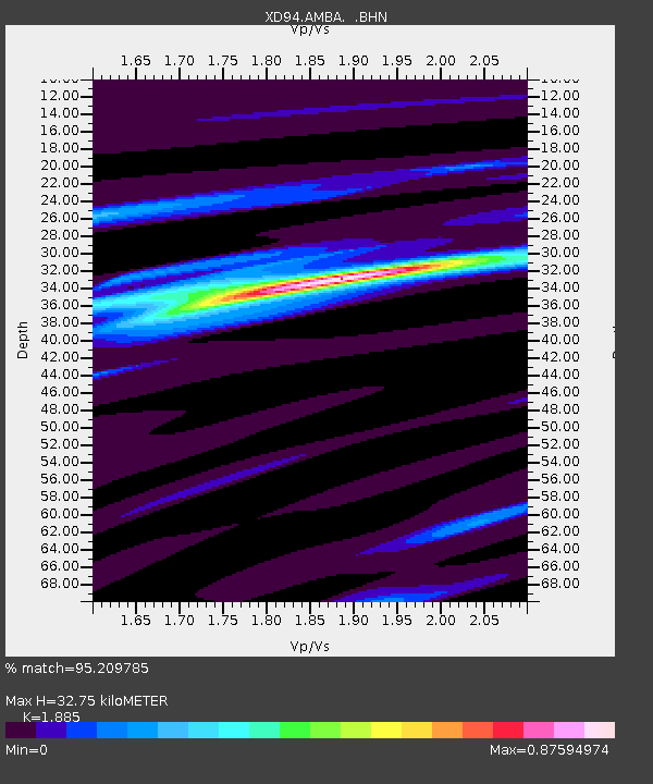
| Estimated Moho Depth: |
32.75 km |
| Estimated Crust Vp/Vs: |
1.88 |
| Assumed Crust Vp: |
6.502 km/s |
| Estimated Crust Vs: |
3.449 km/s |
| Estimated Crust Poisson's Ratio: |
0.30 |
|
| Radial Match: |
95.209785 % |
| Radial Bump: |
234 |
| Transverse Match: |
87.397675 % |
| Transverse Bump: |
400 |
| SOD ConfigId: |
6273 |
| Insert Time: |
2010-03-08 22:47:02.767 +0000 |
| GWidth: |
2.5 |
| Max Bumps: |
400 |
| Tol: |
0.001 |
|
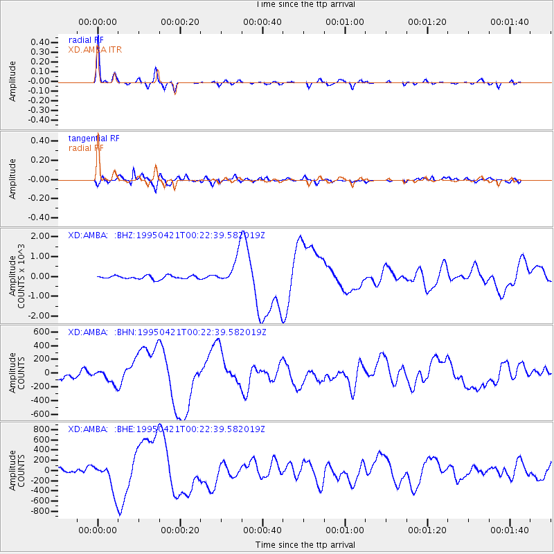
Signal To Noise
| Channel | StoN | STA | LTA |
| XD:AMBA: :BHN:19950421T00:22:39.582019Z | 1.2389702 | 86.42767 | 69.757675 |
| XD:AMBA: :BHE:19950421T00:22:39.582019Z | 3.5856476 | 285.61142 | 79.65407 |
| XD:AMBA: :BHZ:19950421T00:22:39.582019Z | 9.665298 | 810.85956 | 83.89389 |
| Arrivals |
| Ps | 4.5 SECOND |
| PpPs | 14 SECOND |
| PsPs/PpSs | 19 SECOND |


