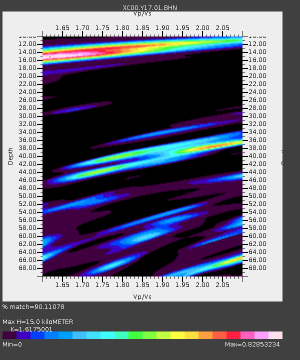
Y17 Y17 - Earthquake Result Viewer
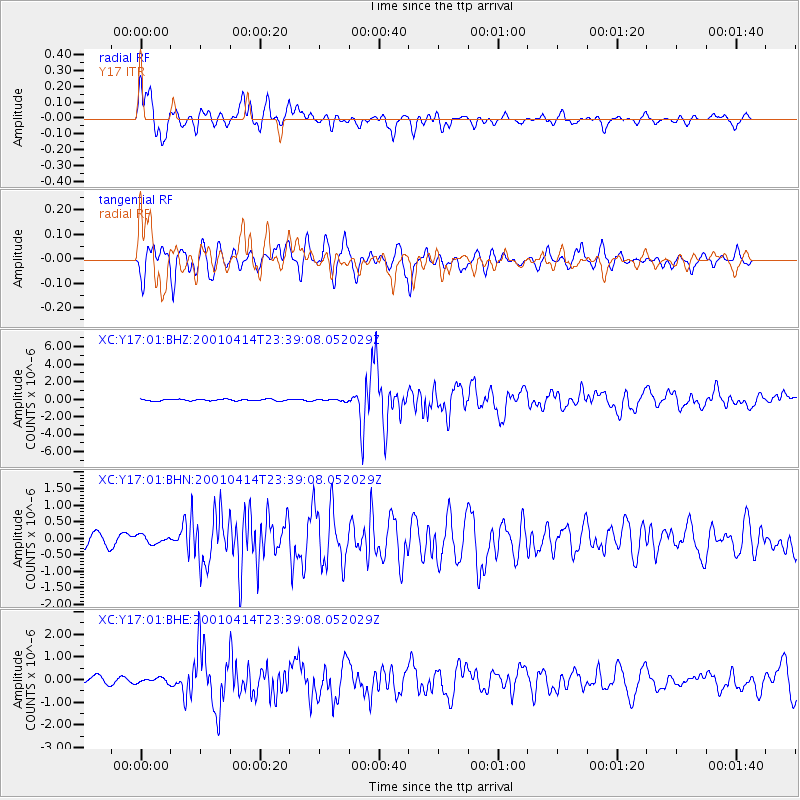
Earthquake location: Southeast Of Honshu, Japan
Earthquake latitude/longitude: 30.1/141.8
Earthquake time(UTC): 2001/04/14 (104) 23:27:26 GMT
Earthquake Depth: 10 km
Earthquake Magnitude: 6.0 MB, 5.8 MS, 6.0 MW, 6.0 ME
Earthquake Catalog/Contributor: WHDF/NEIC
Network: XC Yellowstone Intermountain Seismic Array
Station: Y17 Y17
Lat/Lon: 44.10 N/111.19 W
Elevation: 1762 m
Distance: 80.6 deg
Az: 44.28 deg
Baz: 302.878 deg
Ray Param: 0.04814983
Estimated Moho Depth: 15.0 km
Estimated Crust Vp/Vs: 1.62
Assumed Crust Vp: 6.35 km/s
Estimated Crust Vs: 3.926 km/s
Estimated Crust Poisson's Ratio: 0.19
Radial Match: 90.11078 %
Radial Bump: 400
Transverse Match: 84.43191 %
Transverse Bump: 400
SOD ConfigId: 4714
Insert Time: 2010-02-26 14:57:40.966 +0000
GWidth: 2.5
Max Bumps: 400
Tol: 0.001

Signal To Noise

ChannelStoNSTALTA
XC:Y17:01:BHN:20010414T23:39:08.052029Z0.93183231.5275465E-71.6392934E-7
XC:Y17:01:BHE:20010414T23:39:08.052029Z0.74596921.17532664E-71.57557E-7
XC:Y17:01:BHZ:20010414T23:39:08.052029Z1.04109741.0196886E-79.7943634E-8
Arrivals
Ps1.5 SECOND
PpPs6.0 SECOND
PsPs/PpSs7.5 SECOND