You are here: Home > Network List > XD94 - Tanzania BB Experiment Stations List
> Station KIBA XD.KIBA > Earthquake Result Viewer
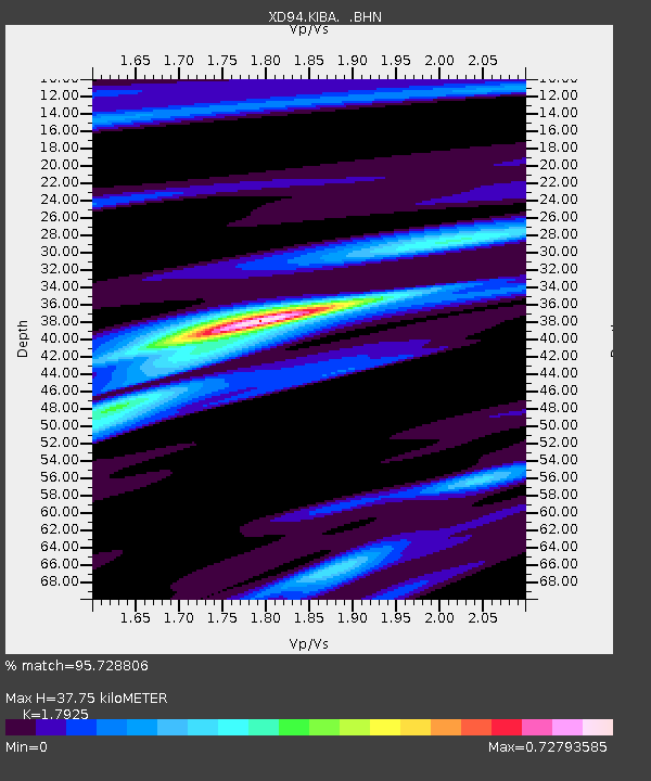
KIBA XD.KIBA - Earthquake Result Viewer
| Earthquake location: |
Samar, Philippines |
| Earthquake latitude/longitude: |
12.0/125.7 |
| Earthquake time(UTC): |
1995/04/21 (111) 00:09:56 GMT |
| Earthquake Depth: |
33 km |
| Earthquake Magnitude: |
6.1 MB, 6.9 MS, 6.9 UNKNOWN, 6.8 MW |
| Earthquake Catalog/Contributor: |
WHDF/NEIC |
|
| Network: |
XD Tanzania BB Experiment |
| Station: |
KIBA XD.KIBA |
| Lat/Lon: |
5.32 S/36.57 E |
| Elevation: |
1500 m |
|
| Distance: |
90.2 deg |
| Az: |
264.648 deg |
| Baz: |
78.05 deg |
| Ray Param: |
0.041683346 |
| Estimated Moho Depth: |
37.75 km |
| Estimated Crust Vp/Vs: |
1.79 |
| Assumed Crust Vp: |
6.65 km/s |
| Estimated Crust Vs: |
3.71 km/s |
| Estimated Crust Poisson's Ratio: |
0.27 |
|
| Radial Match: |
95.728806 % |
| Radial Bump: |
287 |
| Transverse Match: |
77.419914 % |
| Transverse Bump: |
400 |
| SOD ConfigId: |
6273 |
| Insert Time: |
2010-03-08 22:49:43.073 +0000 |
| GWidth: |
2.5 |
| Max Bumps: |
400 |
| Tol: |
0.001 |
|

Signal To Noise
| Channel | StoN | STA | LTA |
| XD:KIBA: :BHN:19950421T00:22:22.181018Z | 2.3068159 | 100.86649 | 43.72542 |
| XD:KIBA: :BHE:19950421T00:22:22.181018Z | 7.5473742 | 400.62363 | 53.081196 |
| XD:KIBA: :BHZ:19950421T00:22:22.181018Z | 19.680222 | 1227.4741 | 62.370945 |
| Arrivals |
| Ps | 4.6 SECOND |
| PpPs | 16 SECOND |
| PsPs/PpSs | 20 SECOND |


