
Station XD KIBA - XD.KIBA
Network: XD94 - Tanzania BB Experiment
Nearby stations (2 deg radius)

| Station | Name | (Lat, Lon) | Start / End | Elevation |
| KIBA | XD.KIBA | (-5.32, 36.57) | 1994-06-01 / 1995-05-21 | 1500 m |
| Crust2 Type: | IE,late Proter., no seds. |
| Thickness Estimate: | 39 km |
| Thickness StdDev: | 3.1 km |
| Vp/Vs Estimate: | 1.73 |
| Vp/Vs StdDev: | 0.06 |
| Vs Estimate: | 3.849 km/s |
| Poisson's Ratio: | 0.25 |
| Peak Value: | 0.03 |
| Assumed Vp: | 6.65 km/s |
| Ps Weight: | 0.33333334 |
| PpPs Weight: | 0.33333334 |
| PsPs Weight: | 0.33333328 |
| Residual Complexity: | 0.652 |
| Nearby stations H: | +- |
| (2.0 deg) Vp/Vs: | +- |
14 with match > 90% ( 42.424244 %) and 22 with match > 80% ( 66.666664 %) out of 33.
Download stack as xyz text file.
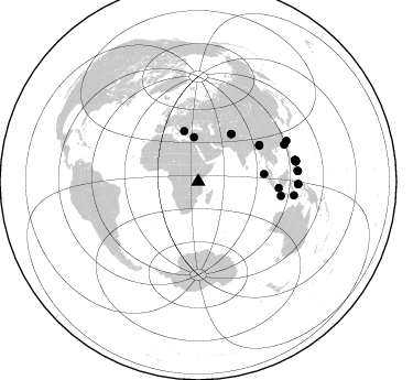
Azimuth Distribution of Events:
Prior Results for this Station
| Study | Thickness | Vp/Vs | Vp | Vs | Poissons Ratio | Extra |
| EARS | 39 km | 1.73 | 6.65 km/s | 3.849 km/s | 0.25 | |
| Crust2.0 | 36 km | 1.77 | 6.65 km/s | 3.758 km/s | 0.27 | IE,late Proter., no seds. |
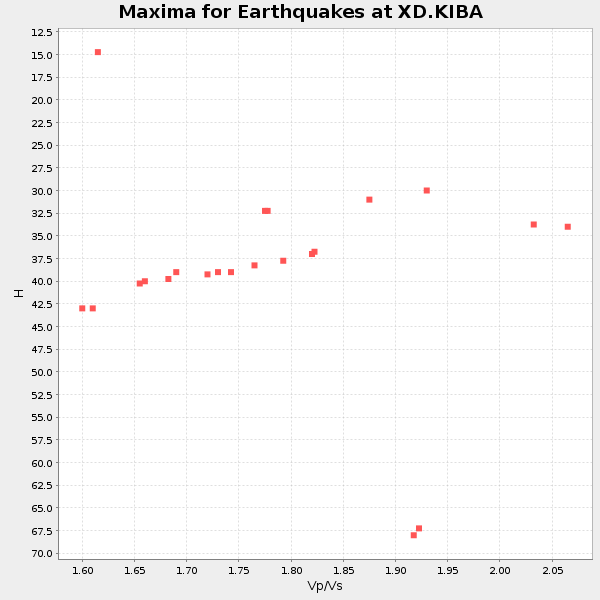
| Global Maxima | 39 km | 1.73 | 6.65 km/s | 3.849 km/s | 0.25 | amp=0.030396836 |
| Local Maxima 1 | 31 km | 1.86 | 6.65 km/s | 3.57 km/s | 0.30 | amp=0.023982074 |
| Local Maxima 2 | 42 km | 1.65 | 6.65 km/s | 4.03 km/s | 0.21 | amp=0.01941405 |
| Local Maxima 3 | 34 km | 2.06 | 6.65 km/s | 3.236 km/s | 0.34 | amp=0.0090217125 |
| Local Maxima 4 | 50 km | 1.60 | 6.65 km/s | 4.156 km/s | 0.18 | amp=0.0075299344 |
| Predicted Arrivals for vertical incidence (zero ray parameter) | |
| Ps | 4.27 SECOND |
| PpPs | 16.00 SECOND |
| PsPs/PpSs | 20.26 SECOND |
Events Processed for this Station
Download zip of receiver functions as SAC
Plot maxima for each earthquake.
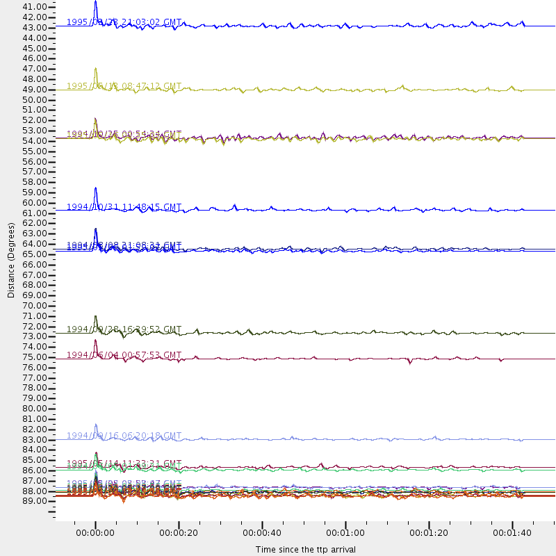
Events Used in the Stack
(22 events)| Radial Match | Distance | Baz | FERegion | Time | Lat/Lon | Depth | Magnitude |
| 97.59556 | 84.8 deg | 66.87 deg | Taiwan Region | 1994/09/16 06:20:18 GMT | (22.5, 118.7) | 12 km | 6.5 MB, 6.7 MS, 6.8 UNKNOWN, 6.7 MW |
| 97.472084 | 76.1 deg | 99.747 deg | South Of Java, Indonesia | 1994/06/04 00:57:53 GMT | (-10.8, 113.4) | 33 km | 5.8 MB, 6.2 MS, 6.0 UNKNOWN |
| 96.79897 | 64.5 deg | 59.228 deg | Myanmar-India Border Region | 1995/05/06 01:59:07 GMT | (25.0, 95.3) | 122 km | 6.4 MB, 6.5 UNKNOWN, 6.4 MW |
| 96.536415 | 89.9 deg | 77.398 deg | Samar, Philippines | 1995/05/05 03:53:47 GMT | (12.6, 125.3) | 33 km | 6.2 MB, 7.0 MS, 7.1 UNKNOWN, 7.0 MW |
| 95.92479 | 64.4 deg | 59.492 deg | Myanmar | 1994/08/08 21:08:31 GMT | (24.7, 95.2) | 127 km | 6.0 MB, 5.1 UNKNOWN, 6.1 MW |
| 95.728806 | 90.2 deg | 78.05 deg | Samar, Philippines | 1995/04/21 00:09:56 GMT | (12.0, 125.7) | 33 km | 6.1 MB, 6.9 MS, 6.9 UNKNOWN, 6.8 MW |
| 95.673 | 90.5 deg | 77.931 deg | Samar, Philippines | 1995/04/21 05:17:00 GMT | (12.1, 125.9) | 23 km | 5.6 MB, 6.9 MS, 6.7 UNKNOWN, 6.7 MW |
| 95.46784 | 87.8 deg | 98.174 deg | Timor Region | 1995/05/14 11:33:21 GMT | (-8.4, 125.1) | 33 km | 6.1 MB, 6.9 MS, 7.1 UNKNOWN, 6.9 MW |
| 95.07862 | 73.4 deg | 94.421 deg | Java Sea | 1994/09/28 16:39:52 GMT | (-5.8, 110.3) | 643 km | 5.7 MB, 6.7 UNKNOWN, 6.6 MW |
| 94.59505 | 47.3 deg | 344.451 deg | Greece | 1995/05/13 08:47:12 GMT | (40.1, 21.7) | 13 km | 6.2 MB, 6.5 MS, 6.6 UNKNOWN, 6.5 MD |
| 94.26548 | 90.8 deg | 83.804 deg | Mindanao, Philippines | 1995/04/20 08:45:10 GMT | (6.3, 126.8) | 85 km | 6.2 MB, 6.6 UNKNOWN, 6.5 MW |
| 94.19607 | 60.2 deg | 83.465 deg | Northern Sumatra, Indonesia | 1994/10/31 11:48:15 GMT | (3.0, 96.3) | 46 km | 5.6 MB, 6.1 MS, 6.3 UNKNOWN, 6.2 MW |
| 92.806786 | 90.0 deg | 77.645 deg | Samar, Philippines | 1995/04/23 05:08:03 GMT | (12.4, 125.4) | 33 km | 6.0 MB, 6.6 MS, 6.7 UNKNOWN, 6.7 MW |
| 92.09019 | 90.8 deg | 91.424 deg | Halmahera, Indonesia | 1995/02/13 15:04:26 GMT | (-1.4, 127.5) | 33 km | 6.2 MB, 6.8 MS, 6.8 UNKNOWN, 6.7 MW |
| 85.937546 | 88.1 deg | 65.35 deg | Taiwan Region | 1994/06/05 01:09:31 GMT | (24.5, 122.0) | 16 km | 6.0 MB, 6.5 MS, 6.1 UNKNOWN, 6.4 MW |
| 85.27591 | 90.6 deg | 78.312 deg | Philippine Islands Region | 1995/04/29 09:44:00 GMT | (11.8, 126.0) | 33 km | 5.4 MB, 6.0 MS, 6.1 UNKNOWN, 6.0 MW |
| 84.79355 | 90.7 deg | 91.449 deg | Halmahera, Indonesia | 1995/02/13 12:29:55 GMT | (-1.4, 127.4) | 33 km | 5.8 MB, 6.0 MS, 6.1 UNKNOWN, 5.9 MW |
| 84.37276 | 52.4 deg | 35.103 deg | Hindu Kush Region, Afghanistan | 1994/10/25 00:54:34 GMT | (36.3, 70.9) | 244 km | 5.9 MB, 6.2 UNKNOWN, 5.9 MW |
| 83.58436 | 40.3 deg | 354.543 deg | Cyprus Region | 1995/02/23 21:03:02 GMT | (35.0, 32.3) | 15 km | 5.8 MB, 5.7 MS, 5.9 UNKNOWN, 5.8 MW |
| 83.26807 | 90.9 deg | 83.95 deg | Mindanao, Philippines | 1995/04/04 17:21:04 GMT | (6.2, 127.0) | 86 km | 5.5 MB |
| 82.41101 | 52.5 deg | 34.926 deg | Hindu Kush Region, Afghanistan | 1995/05/16 03:35:03 GMT | (36.5, 70.9) | 190 km | 5.7 MB, 5.9 UNKNOWN, 5.8 MW |
| 81.248795 | 90.4 deg | 78.496 deg | Samar, Philippines | 1995/05/08 18:08:09 GMT | (11.6, 125.9) | 33 km | 5.6 MB, 6.2 MS, 6.3 UNKNOWN, 6.3 MW |
Losers
(11 events)| Radial Match | Distance | Baz | FERegion | Time | Lat/Lon | Depth | Magnitude | Reason |
| 77.706375 | 90.7 deg | 97.54 deg | Banda Sea | 1994/07/13 11:45:25 GMT | (-7.5, 127.9) | 185 km | 6.4 MB, 6.8 UNKNOWN, 6.5 MW | |
| 76.904594 | 66.0 deg | 50.975 deg | Xizang | 1994/06/29 18:22:36 GMT | (32.5, 93.7) | 33 km | 5.8 MB, 5.5 MS, 5.3 UNKNOWN, 5.7 MW | |
| 76.7069 | 80.7 deg | 305.328 deg | Northern Mid-Atlantic Ridge | 1995/04/17 07:14:35 GMT | (33.8, -38.6) | 10 km | 5.8 MB, 5.8 MS, 5.9 UNKNOWN, 6.1 MW | |
| 75.463 | 90.1 deg | 84.819 deg | Mindanao, Philippines | 1995/02/19 00:17:48 GMT | (5.2, 126.2) | 104 km | 5.9 MB, 6.1 UNKNOWN, 6.1 MW | |
| 72.62951 | 72.0 deg | 93.743 deg | Java Sea | 1995/05/13 21:00:54 GMT | (-5.2, 108.9) | 554 km | 5.7 MB, 5.9 UNKNOWN, 5.8 MW | |
| 59.49361 | 87.8 deg | 83.794 deg | Mindanao, Philippines | 1995/04/23 06:38:11 GMT | (6.0, 123.8) | 531 km | 5.5 MB | |
| 58.73265 | 92.1 deg | 88.339 deg | Halmahera, Indonesia | 1995/05/04 02:18:51 GMT | (1.9, 128.5) | 55 km | 6.0 MB, 6.0 MS, 6.1 UNKNOWN, 6.1 MW | |
| 57.923023 | 66.7 deg | 40.173 deg | Southern Xinjiang, China | 1995/05/15 04:05:58 GMT | (41.7, 88.8) | 0.0 km | 6.1 MB | |
| 54.13674 | 95.4 deg | 61.197 deg | Ryukyu Islands, Japan | 1994/09/13 04:28:01 GMT | (29.3, 129.9) | 37 km | 5.8 MB, 6.3 MS, 6.2 UNKNOWN, 6.1 MW | |
| 52.45129 | 88.6 deg | 94.467 deg | Banda Sea | 1994/07/16 18:05:07 GMT | (-4.6, 125.6) | 461 km | 5.8 MB | |
| 52.02338 | 89.9 deg | 84.036 deg | Mindanao, Philippines | 1994/07/06 09:13:11 GMT | (6.0, 125.9) | 164 km | 5.7 MB, 6.1 UNKNOWN |
