You are here: Home > Network List > XD94 - Tanzania BB Experiment Stations List
> Station LONG XD.LONG > Earthquake Result Viewer
LONG XD.LONG - Earthquake Result Viewer
| Earthquake location: |
Myanmar |
| Earthquake latitude/longitude: |
24.7/95.2 |
| Earthquake time(UTC): |
1994/08/08 (220) 21:08:31 GMT |
| Earthquake Depth: |
127 km |
| Earthquake Magnitude: |
6.0 MB, 5.1 UNKNOWN, 6.1 MW |
| Earthquake Catalog/Contributor: |
WHDF/NEIC |
|
| Network: |
XD Tanzania BB Experiment |
| Station: |
LONG XD.LONG |
| Lat/Lon: |
2.73 S/36.70 E |
| Elevation: |
1380 m |
|
| Distance: |
63.0 deg |
| Az: |
253.038 deg |
| Baz: |
60.558 deg |
| Ray Param: |
0.059530314 |
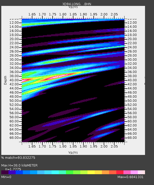
| Estimated Moho Depth: |
38.0 km |
| Estimated Crust Vp/Vs: |
1.78 |
| Assumed Crust Vp: |
6.601 km/s |
| Estimated Crust Vs: |
3.713 km/s |
| Estimated Crust Poisson's Ratio: |
0.27 |
|
| Radial Match: |
93.832275 % |
| Radial Bump: |
374 |
| Transverse Match: |
83.61048 % |
| Transverse Bump: |
400 |
| SOD ConfigId: |
16938 |
| Insert Time: |
2010-03-08 22:51:50.084 +0000 |
| GWidth: |
2.5 |
| Max Bumps: |
400 |
| Tol: |
0.001 |
|

Signal To Noise
| Channel | StoN | STA | LTA |
| XD:LONG: :BHN:19940808T21:18:14.196021Z | 4.4261928 | 297.8936 | 67.302444 |
| XD:LONG: :BHE:19940808T21:18:14.196021Z | 9.373268 | 665.10675 | 70.957825 |
| XD:LONG: :BHZ:19940808T21:18:14.196021Z | 20.356672 | 1793.1825 | 88.08819 |
| Arrivals |
| Ps | 4.7 SECOND |
| PpPs | 15 SECOND |
| PsPs/PpSs | 20 SECOND |


