
Station XD LONG - XD.LONG
Network: XD94 - Tanzania BB Experiment
Nearby stations (2 deg radius)
| Station | Name | (Lat, Lon) | Start / End | Elevation |
| LONG | XD.LONG | (-2.73, 36.70) | 1994-06-09 / 1995-05-25 | 1380 m |
| Crust2 Type: | X5,thick Rift 0.25 km sediments |
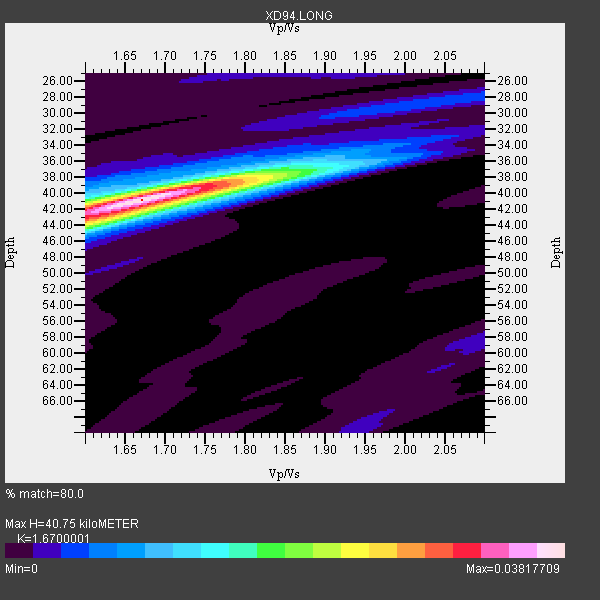
| Thickness Estimate: | 41 km |
| Thickness StdDev: | 0.8 km |
| Vp/Vs Estimate: | 1.67 |
| Vp/Vs StdDev: | 0.03 |
| Vs Estimate: | 3.952 km/s |
| Poisson's Ratio: | 0.22 |
| Peak Value: | 0.04 |
| Assumed Vp: | 6.601 km/s |
| Ps Weight: | 0.33333334 |
| PpPs Weight: | 0.33333334 |
| PsPs Weight: | 0.33333328 |
| Residual Complexity: | 0.471 |
| Nearby stations H: | +- |
| (2.0 deg) Vp/Vs: | +- |
12 with match > 90% ( 42.857143 %) and 15 with match > 80% ( 53.57143 %) out of 28.
Download stack as xyz text file.
Azimuth Distribution of Events:

Prior Results for this Station
| Study | Thickness | Vp/Vs | Vp | Vs | Poissons Ratio | Extra |
| EARS | 41 km | 1.67 | 6.601 km/s | 3.952 km/s | 0.22 | |
| Crust2.0 | 38 km | 1.77 | 6.601 km/s | 3.729 km/s | 0.27 | X5,thick Rift 0.25 km sediments |
| Global Maxima | 41 km | 1.67 | 6.601 km/s | 3.952 km/s | 0.22 | amp=0.03817709 |
| Local Maxima 1 | 44 km | 1.60 | 6.601 km/s | 4.125 km/s | 0.18 | amp=0.017259365 |
| Local Maxima 2 | 38 km | 1.80 | 6.601 km/s | 3.672 km/s | 0.28 | amp=0.015059666 |
| Local Maxima 3 | 42 km | 1.60 | 6.601 km/s | 4.125 km/s | 0.18 | amp=0.0072030006 |
| Local Maxima 4 | 40 km | 1.75 | 6.601 km/s | 3.772 km/s | 0.26 | amp=0.0059069768 |
| Predicted Arrivals for vertical incidence (zero ray parameter) | |
| Ps | 4.14 SECOND |
| PpPs | 16.48 SECOND |
| PsPs/PpSs | 20.62 SECOND |
Events Processed for this Station
Download zip of receiver functions as SAC
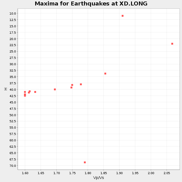
Plot maxima for each earthquake.
Events Used in the Stack
(15 events)| Radial Match | Distance | Baz | FERegion | Time | Lat/Lon | Depth | Magnitude |
| 97.6398 | 88.0 deg | 98.26 deg | Timor Region | 1995/05/14 11:33:21 GMT | (-8.4, 125.1) | 33 km | 6.1 MB, 6.9 MS, 7.1 UNKNOWN, 6.9 MW |
| 97.53781 | 89.6 deg | 78.045 deg | Samar, Philippines | 1995/04/21 00:09:56 GMT | (12.0, 125.7) | 33 km | 6.1 MB, 6.9 MS, 6.9 UNKNOWN, 6.8 MW |
| 96.69783 | 89.8 deg | 77.915 deg | Samar, Philippines | 1995/04/21 05:17:00 GMT | (12.1, 125.9) | 23 km | 5.6 MB, 6.9 MS, 6.7 UNKNOWN, 6.7 MW |
| 95.68315 | 96.4 deg | 47.917 deg | Primor'ye, Russia | 1994/07/21 18:36:31 GMT | (42.3, 132.9) | 473 km | 6.4 MB, 7.2 UNKNOWN |
| 95.14337 | 73.3 deg | 95.005 deg | Java Sea | 1994/11/15 20:18:11 GMT | (-5.6, 110.2) | 559 km | 6.2 MB, 6.5 UNKNOWN, 6.5 MW |
| 94.71108 | 85.2 deg | 76.256 deg | Mindoro, Philippines | 1994/11/14 19:15:30 GMT | (13.5, 121.1) | 33 km | 6.1 MB, 7.1 MS, 7.1 UNKNOWN, 7.1 MW |
| 94.5132 | 90.4 deg | 83.767 deg | Mindanao, Philippines | 1995/04/20 08:45:10 GMT | (6.3, 126.8) | 85 km | 6.2 MB, 6.6 UNKNOWN, 6.5 MW |
| 94.1552 | 73.5 deg | 95.181 deg | Java Sea | 1994/09/28 16:39:52 GMT | (-5.8, 110.3) | 643 km | 5.7 MB, 6.7 UNKNOWN, 6.6 MW |
| 93.832275 | 63.0 deg | 60.558 deg | Myanmar | 1994/08/08 21:08:31 GMT | (24.7, 95.2) | 127 km | 6.0 MB, 5.1 UNKNOWN, 6.1 MW |
| 92.86519 | 62.0 deg | 203.986 deg | Southern Mid-Atlantic Ridge | 1995/05/23 22:10:11 GMT | (-56.1, -3.2) | 10 km | 5.3 MB, 6.6 MS, 6.8 UNKNOWN, 6.7 MW |
| 90.80896 | 59.8 deg | 84.93 deg | Northern Sumatra, Indonesia | 1994/10/31 11:48:15 GMT | (3.0, 96.3) | 46 km | 5.6 MB, 6.1 MS, 6.3 UNKNOWN, 6.2 MW |
| 90.33418 | 44.8 deg | 343.639 deg | Greece | 1995/05/13 08:47:12 GMT | (40.1, 21.7) | 13 km | 6.2 MB, 6.5 MS, 6.6 UNKNOWN, 6.5 MD |
| 88.1597 | 64.5 deg | 60.17 deg | Myanmar | 1994/11/21 08:16:36 GMT | (25.5, 96.7) | 33 km | 5.6 MB, 5.9 MS, 6.1 UNKNOWN, 6.0 MW |
| 87.671486 | 90.9 deg | 97.497 deg | Banda Sea | 1994/07/13 11:45:25 GMT | (-7.5, 127.9) | 185 km | 6.4 MB, 6.8 UNKNOWN, 6.5 MW |
| 85.95591 | 89.8 deg | 78.484 deg | Samar, Philippines | 1995/05/08 18:08:09 GMT | (11.6, 125.9) | 33 km | 5.6 MB, 6.2 MS, 6.3 UNKNOWN, 6.3 MW |
Losers
(13 events)| Radial Match | Distance | Baz | FERegion | Time | Lat/Lon | Depth | Magnitude | Reason |
| 79.81382 | 64.3 deg | 51.864 deg | Xizang | 1994/06/29 18:22:36 GMT | (32.5, 93.7) | 33 km | 5.8 MB, 5.5 MS, 5.3 UNKNOWN, 5.7 MW | |
| 78.224174 | 72.1 deg | 94.571 deg | Java Sea | 1995/05/13 21:00:54 GMT | (-5.2, 108.9) | 554 km | 5.7 MB, 5.9 UNKNOWN, 5.8 MW | |
| 77.49696 | 89.9 deg | 78.293 deg | Philippine Islands Region | 1995/04/29 09:44:00 GMT | (11.8, 126.0) | 33 km | 5.4 MB, 6.0 MS, 6.1 UNKNOWN, 6.0 MW | |
| 69.16359 | 89.4 deg | 78.135 deg | Samar, Philippines | 1995/04/21 00:30:12 GMT | (11.9, 125.6) | 33 km | 6.3 MB, 7.0 MS, 7.2 UNKNOWN | |
| 69.10841 | 71.8 deg | 205.653 deg | Southwestern Atlantic Ocean | 1995/04/14 13:15:16 GMT | (-60.7, -20.0) | 10 km | 5.4 MB, 5.9 MS, 6.5 UNKNOWN, 6.3 MW | |
| 68.70669 | 61.3 deg | 83.716 deg | Northern Sumatra, Indonesia | 1994/11/20 18:34:35 GMT | (4.2, 97.6) | 167 km | 5.7 MB | |
| 63.93693 | 94.5 deg | 96.524 deg | Tanimbar Islands Reg., Indonesia | 1994/08/04 22:15:37 GMT | (-6.3, 131.5) | 33 km | 6.1 MB, 5.6 MS, 6.1 UNKNOWN | |
| 62.425186 | 87.4 deg | 33.106 deg | East Of Lake Baykal, Russia | 1994/08/21 15:56:01 GMT | (56.7, 117.8) | 33 km | 5.7 MB, 5.8 MS, 6.0 UNKNOWN, 6.0 MW | |
| 53.97162 | 91.2 deg | 97.364 deg | Banda Sea | 1995/01/19 09:55:34 GMT | (-7.3, 128.3) | 170 km | 5.8 MB, 6.1 UNKNOWN, 5.9 MW | |
| 50.525288 | 88.7 deg | 94.518 deg | Banda Sea | 1994/07/16 18:05:07 GMT | (-4.6, 125.6) | 461 km | 5.8 MB | |
| 49.981705 | 70.4 deg | 139.64 deg | Southeast Indian Ridge | 1994/07/28 08:03:02 GMT | (-47.3, 100.4) | 10 km | 5.7 MS, 5.2 MB, 6.1 UNKNOWN | |
| 43.850975 | 73.9 deg | 212.113 deg | South Sandwich Islands Region | 1995/03/26 02:16:16 GMT | (-55.9, -28.2) | 77 km | 6.1 MB, 5.9 MS, 6.4 UNKNOWN, 6.3 MW | |
| 43.369827 | 90.5 deg | 83.908 deg | Mindanao, Philippines | 1995/04/04 17:21:04 GMT | (6.2, 127.0) | 86 km | 5.5 MB |
