You are here: Home > Network List > XD94 - Tanzania BB Experiment Stations List
> Station LONG XD.LONG > Earthquake Result Viewer
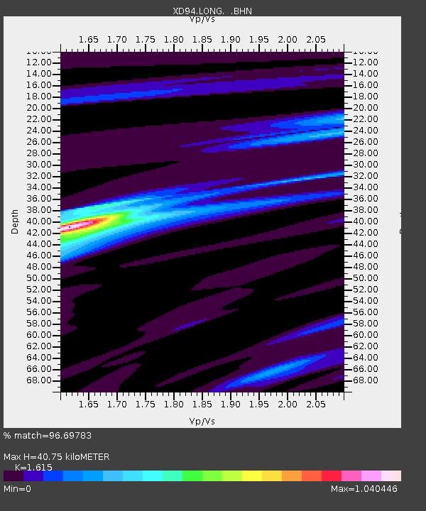
LONG XD.LONG - Earthquake Result Viewer
| Earthquake location: |
Samar, Philippines |
| Earthquake latitude/longitude: |
12.1/125.9 |
| Earthquake time(UTC): |
1995/04/21 (111) 05:17:00 GMT |
| Earthquake Depth: |
23 km |
| Earthquake Magnitude: |
5.6 MB, 6.9 MS, 6.7 UNKNOWN, 6.7 MW |
| Earthquake Catalog/Contributor: |
WHDF/NEIC |
|
| Network: |
XD Tanzania BB Experiment |
| Station: |
LONG XD.LONG |
| Lat/Lon: |
2.73 S/36.70 E |
| Elevation: |
1380 m |
|
| Distance: |
89.8 deg |
| Az: |
267.196 deg |
| Baz: |
77.915 deg |
| Ray Param: |
0.0417144 |
| Estimated Moho Depth: |
40.75 km |
| Estimated Crust Vp/Vs: |
1.62 |
| Assumed Crust Vp: |
6.601 km/s |
| Estimated Crust Vs: |
4.087 km/s |
| Estimated Crust Poisson's Ratio: |
0.19 |
|
| Radial Match: |
96.69783 % |
| Radial Bump: |
300 |
| Transverse Match: |
80.460205 % |
| Transverse Bump: |
400 |
| SOD ConfigId: |
6273 |
| Insert Time: |
2010-03-08 22:51:58.741 +0000 |
| GWidth: |
2.5 |
| Max Bumps: |
400 |
| Tol: |
0.001 |
|

Signal To Noise
| Channel | StoN | STA | LTA |
| XD:LONG: :BHN:19950421T05:29:26.115002Z | 0.9243975 | 33.98649 | 36.766098 |
| XD:LONG: :BHE:19950421T05:29:26.115002Z | 2.209624 | 104.208206 | 47.161057 |
| XD:LONG: :BHZ:19950421T05:29:26.115002Z | 4.764902 | 325.49432 | 68.310814 |
| Arrivals |
| Ps | 3.9 SECOND |
| PpPs | 16 SECOND |
| PsPs/PpSs | 20 SECOND |


