You are here: Home > Network List > XD94 - Tanzania BB Experiment Stations List
> Station MBWE XD.MBWE > Earthquake Result Viewer
MBWE XD.MBWE - Earthquake Result Viewer
| Earthquake location: |
Myanmar |
| Earthquake latitude/longitude: |
24.7/95.2 |
| Earthquake time(UTC): |
1994/08/08 (220) 21:08:31 GMT |
| Earthquake Depth: |
127 km |
| Earthquake Magnitude: |
6.0 MB, 5.1 UNKNOWN, 6.1 MW |
| Earthquake Catalog/Contributor: |
WHDF/NEIC |
|
| Network: |
XD Tanzania BB Experiment |
| Station: |
MBWE XD.MBWE |
| Lat/Lon: |
4.96 S/34.35 E |
| Elevation: |
1100 m |
|
| Distance: |
66.1 deg |
| Az: |
252.181 deg |
| Baz: |
60.346 deg |
| Ray Param: |
0.057493784 |
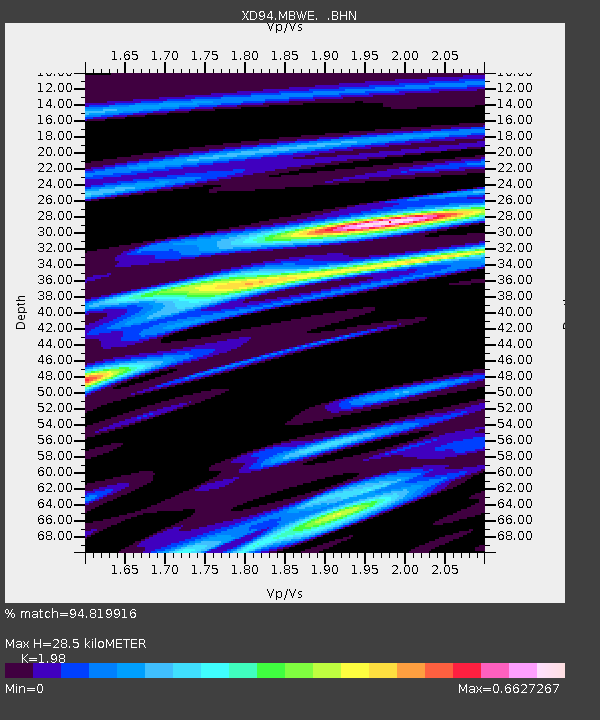
| Estimated Moho Depth: |
28.5 km |
| Estimated Crust Vp/Vs: |
1.98 |
| Assumed Crust Vp: |
6.601 km/s |
| Estimated Crust Vs: |
3.334 km/s |
| Estimated Crust Poisson's Ratio: |
0.33 |
|
| Radial Match: |
94.819916 % |
| Radial Bump: |
315 |
| Transverse Match: |
80.48619 % |
| Transverse Bump: |
400 |
| SOD ConfigId: |
16938 |
| Insert Time: |
2010-03-08 22:52:16.425 +0000 |
| GWidth: |
2.5 |
| Max Bumps: |
400 |
| Tol: |
0.001 |
|

Signal To Noise
| Channel | StoN | STA | LTA |
| XD:MBWE: :BHN:19940808T21:18:34.561011Z | 3.7013774 | 321.49197 | 86.85738 |
| XD:MBWE: :BHE:19940808T21:18:34.561011Z | 8.808717 | 634.37274 | 72.01648 |
| XD:MBWE: :BHZ:19940808T21:18:34.561011Z | 17.337793 | 1938.0762 | 111.783325 |
| Arrivals |
| Ps | 4.4 SECOND |
| PpPs | 12 SECOND |
| PsPs/PpSs | 17 SECOND |


