
Station XD MBWE - XD.MBWE
Network: XD94 - Tanzania BB Experiment
Nearby stations (2 deg radius)

| Station | Name | (Lat, Lon) | Start / End | Elevation |
| MBWE | XD.MBWE | (-4.96, 34.35) | 1994-05-23 / 1995-03-23 | 1100 m |
| Crust2 Type: | X5,thick Rift 0.25 km sediments |
| Thickness Estimate: | 38 km |
| Thickness StdDev: | 0.3 km |
| Vp/Vs Estimate: | 1.71 |
| Vp/Vs StdDev: | 0.01 |
| Vs Estimate: | 3.871 km/s |
| Poisson's Ratio: | 0.24 |
| Peak Value: | 0.07 |
| Assumed Vp: | 6.601 km/s |
| Ps Weight: | 0.33333334 |
| PpPs Weight: | 0.33333334 |
| PsPs Weight: | 0.33333328 |
| Residual Complexity: | 0.433 |
| Nearby stations H: | +- |
| (2.0 deg) Vp/Vs: | +- |
8 with match > 90% ( 44.444443 %) and 13 with match > 80% ( 72.22222 %) out of 18.
Download stack as xyz text file.
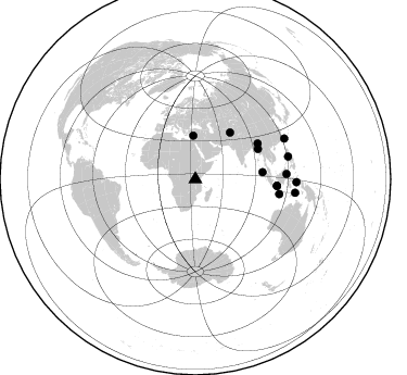
Azimuth Distribution of Events:
Prior Results for this Station
| Study | Thickness | Vp/Vs | Vp | Vs | Poissons Ratio | Extra |
| EARS | 38 km | 1.71 | 6.601 km/s | 3.871 km/s | 0.24 | |
| Crust2.0 | 38 km | 1.77 | 6.601 km/s | 3.729 km/s | 0.27 | X5,thick Rift 0.25 km sediments |
| Global Maxima | 38 km | 1.71 | 6.601 km/s | 3.871 km/s | 0.24 | amp=0.067742735 |
| Local Maxima 1 | 28 km | 1.99 | 6.601 km/s | 3.313 km/s | 0.33 | amp=0.024506604 |
| Local Maxima 2 | 36 km | 1.76 | 6.601 km/s | 3.756 km/s | 0.26 | amp=0.013041873 |
| Local Maxima 3 | 38 km | 1.80 | 6.601 km/s | 3.667 km/s | 0.28 | amp=0.010046699 |
| Local Maxima 4 | 40 km | 1.66 | 6.601 km/s | 3.982 km/s | 0.21 | amp=0.006006552 |
| Predicted Arrivals for vertical incidence (zero ray parameter) | |
| Ps | 4.01 SECOND |
| PpPs | 15.37 SECOND |
| PsPs/PpSs | 19.37 SECOND |
Events Processed for this Station
Download zip of receiver functions as SAC
Plot maxima for each earthquake.
Events Used in the Stack
(13 events)| Radial Match | Distance | Baz | FERegion | Time | Lat/Lon | Depth | Magnitude |
| 97.95239 | 78.4 deg | 99.939 deg | South Of Java, Indonesia | 1994/06/04 00:57:53 GMT | (-10.8, 113.4) | 33 km | 5.8 MB, 6.2 MS, 6.0 UNKNOWN |
| 97.2858 | 63.9 deg | 64.406 deg | Myanmar | 1994/05/29 14:11:51 GMT | (20.5, 94.2) | 42 km | 6.2 MB, 6.2 MS, 5.9 UNKNOWN, 6.5 MW |
| 95.77194 | 88.0 deg | 76.317 deg | Mindoro, Philippines | 1994/11/14 19:15:30 GMT | (13.5, 121.1) | 33 km | 6.1 MB, 7.1 MS, 7.1 UNKNOWN, 7.1 MW |
| 94.819916 | 66.1 deg | 60.346 deg | Myanmar | 1994/08/08 21:08:31 GMT | (24.7, 95.2) | 127 km | 6.0 MB, 5.1 UNKNOWN, 6.1 MW |
| 93.050385 | 62.4 deg | 83.991 deg | Northern Sumatra, Indonesia | 1994/10/31 11:48:15 GMT | (3.0, 96.3) | 46 km | 5.6 MB, 6.1 MS, 6.3 UNKNOWN, 6.2 MW |
| 92.94714 | 93.0 deg | 91.612 deg | Halmahera, Indonesia | 1995/02/13 15:04:26 GMT | (-1.4, 127.5) | 33 km | 6.2 MB, 6.8 MS, 6.8 UNKNOWN, 6.7 MW |
| 92.89369 | 75.5 deg | 94.49 deg | Java Sea | 1994/11/15 20:18:11 GMT | (-5.6, 110.2) | 559 km | 6.2 MB, 6.5 UNKNOWN, 6.5 MW |
| 90.73086 | 39.8 deg | 357.335 deg | Cyprus Region | 1995/02/23 21:03:02 GMT | (35.0, 32.3) | 15 km | 5.8 MB, 5.7 MS, 5.9 UNKNOWN, 5.8 MW |
| 89.765205 | 75.6 deg | 94.669 deg | Java Sea | 1994/09/28 16:39:52 GMT | (-5.8, 110.3) | 643 km | 5.7 MB, 6.7 UNKNOWN, 6.6 MW |
| 88.4578 | 53.4 deg | 36.815 deg | Hindu Kush Region, Afghanistan | 1994/10/25 00:54:34 GMT | (36.3, 70.9) | 244 km | 5.9 MB, 6.2 UNKNOWN, 5.9 MW |
| 83.41307 | 84.1 deg | 86.823 deg | Celebes Sea | 1995/03/06 18:43:42 GMT | (2.7, 118.2) | 33 km | 5.5 MB, 5.8 MS, 6.3 UNKNOWN, 6.1 MW |
| 81.80356 | 89.9 deg | 65.57 deg | Taiwan Region | 1994/06/05 01:09:31 GMT | (24.5, 122.0) | 16 km | 6.0 MB, 6.5 MS, 6.1 UNKNOWN, 6.4 MW |
| 81.080185 | 92.9 deg | 97.736 deg | Banda Sea | 1994/07/13 11:45:25 GMT | (-7.5, 127.9) | 185 km | 6.4 MB, 6.8 UNKNOWN, 6.5 MW |
Losers
(5 events)| Radial Match | Distance | Baz | FERegion | Time | Lat/Lon | Depth | Magnitude | Reason |
| 68.88615 | 67.5 deg | 51.887 deg | Xizang | 1994/06/29 18:22:36 GMT | (32.5, 93.7) | 33 km | 5.8 MB, 5.5 MS, 5.3 UNKNOWN, 5.7 MW | |
| 61.164318 | 62.4 deg | 204.399 deg | Southwestern Atlantic Ocean | 1994/09/15 23:47:30 GMT | (-57.8, -8.7) | 10 km | 5.6 MS, 5.2 MB | |
| 57.075623 | 92.3 deg | 85.005 deg | Mindanao, Philippines | 1995/02/19 00:17:48 GMT | (5.2, 126.2) | 104 km | 5.9 MB, 6.1 UNKNOWN, 6.1 MW | |
| 56.819656 | 51.7 deg | 323.989 deg | Northern Algeria | 1994/08/18 01:13:06 GMT | (35.6, -0.1) | 9.0 km | 5.5 MB, 5.9 MS, 5.8 UNKNOWN | |
| 56.13595 | 90.9 deg | 94.666 deg | Banda Sea | 1994/07/16 18:05:07 GMT | (-4.6, 125.6) | 461 km | 5.8 MB |
