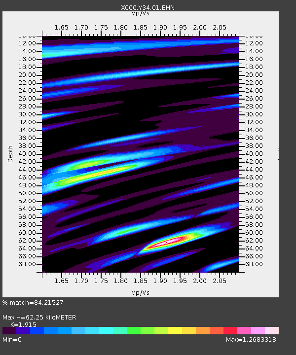
Y34 Y34 - Earthquake Result Viewer
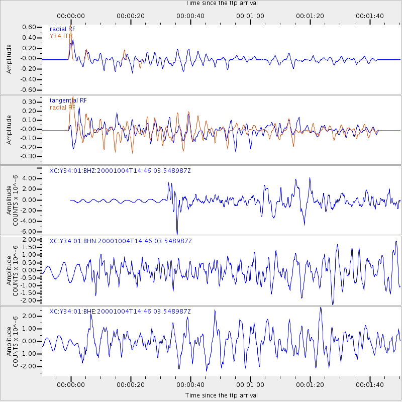
Earthquake location: Windward Islands
Earthquake latitude/longitude: 11.1/-62.6
Earthquake time(UTC): 2000/10/04 (278) 14:37:44 GMT
Earthquake Depth: 110 km
Earthquake Magnitude: 5.6 MB, 5.4 MS, 6.1 MW, 5.9 MD
Earthquake Catalog/Contributor: WHDF/NEIC
Network: XC Yellowstone Intermountain Seismic Array
Station: Y34 Y34
Lat/Lon: 42.97 N/108.56 W
Elevation: 1562 m
Distance: 50.9 deg
Az: 317.136 deg
Baz: 114.541 deg
Ray Param: 0.06739957
Estimated Moho Depth: 62.25 km
Estimated Crust Vp/Vs: 1.91
Assumed Crust Vp: 6.161 km/s
Estimated Crust Vs: 3.217 km/s
Estimated Crust Poisson's Ratio: 0.31
Radial Match: 84.21527 %
Radial Bump: 400
Transverse Match: 72.15569 %
Transverse Bump: 400
SOD ConfigId: 16820
Insert Time: 2010-02-26 14:57:57.185 +0000
GWidth: 2.5
Max Bumps: 400
Tol: 0.001

Signal To Noise

ChannelStoNSTALTA
XC:Y34:01:BHN:20001004T14:46:03.548987Z1.44958284.7014652E-73.243323E-7
XC:Y34:01:BHE:20001004T14:46:03.548987Z1.85852657.0204084E-73.7774055E-7
XC:Y34:01:BHZ:20001004T14:46:03.548987Z6.11059671.3217137E-62.1629863E-7
Arrivals
Ps9.7 SECOND
PpPs28 SECOND
PsPs/PpSs38 SECOND