
Station XC Y34 - Y34
Network: XC00 - Yellowstone Intermountain Seismic Array
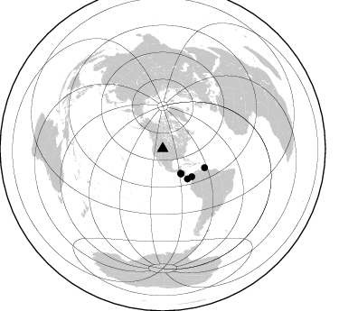
Nearby stations (2 deg radius)
| Station | Name | (Lat, Lon) | Start / End | Elevation |
| Y34 | Y34 | (42.97, -108.56) | 2000-06-20 / 2001-12-31 | 1562 m |
| Crust2 Type: | Q0,orogen/46km no ice, Rockies, Tarim Basin, 4 km seds. |
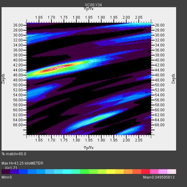
| Thickness Estimate: | 43 km |
| Thickness StdDev: | 8.3 km |
| Vp/Vs Estimate: | 1.71 |
| Vp/Vs StdDev: | 0.09 |
| Vs Estimate: | 3.603 km/s |
| Poisson's Ratio: | 0.24 |
| Peak Value: | 0.05 |
| Assumed Vp: | 6.161 km/s |
| Ps Weight: | 0.33333334 |
| PpPs Weight: | 0.33333334 |
| PsPs Weight: | 0.33333328 |
| Residual Complexity: | 0.612 |
| Nearby stations H: | +- |
| (2.0 deg) Vp/Vs: | +- |
0 with match > 90% ( 0.0 %) and 5 with match > 80% ( 100.0 %) out of 5.
Download stack as xyz text file.
Azimuth Distribution of Events:
Prior Results for this Station
| Study | Thickness | Vp/Vs | Vp | Vs | Poissons Ratio | Extra |
| EARS | 43 km | 1.71 | 6.161 km/s | 3.603 km/s | 0.24 | |
| Crust2.0 | 46 km | 1.75 | 6.161 km/s | 3.511 km/s | 0.26 | Q0,orogen/46km no ice, Rockies, Tarim Basin, 4 km seds. |
| Global Maxima | 43 km | 1.71 | 6.161 km/s | 3.603 km/s | 0.24 | amp=0.049595613 |
| Local Maxima 1 | 64 km | 1.89 | 6.161 km/s | 3.26 km/s | 0.31 | amp=0.026061503 |
| Local Maxima 2 | 25 km | 2.06 | 6.161 km/s | 2.987 km/s | 0.35 | amp=0.021541072 |
| Local Maxima 3 | 44 km | 1.78 | 6.161 km/s | 3.461 km/s | 0.27 | amp=0.02033861 |
| Local Maxima 4 | 68 km | 2.01 | 6.161 km/s | 3.073 km/s | 0.33 | amp=0.016830735 |
| Predicted Arrivals for vertical incidence (zero ray parameter) | |
| Ps | 4.98 SECOND |
| PpPs | 19.02 SECOND |
| PsPs/PpSs | 24.01 SECOND |
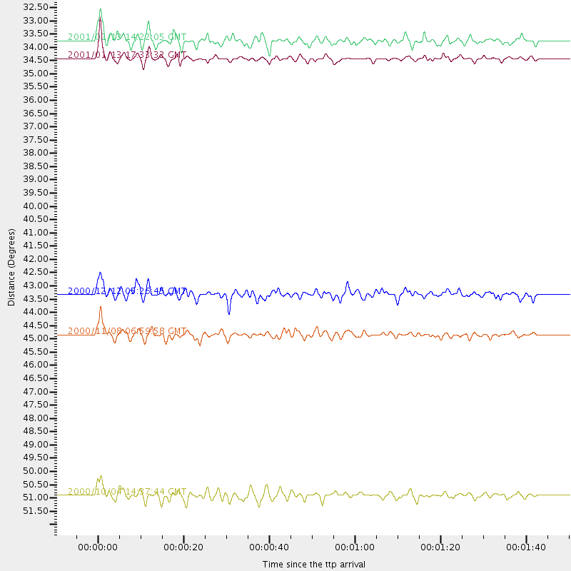
Events Processed for this Station
Download zip of receiver functions as SAC
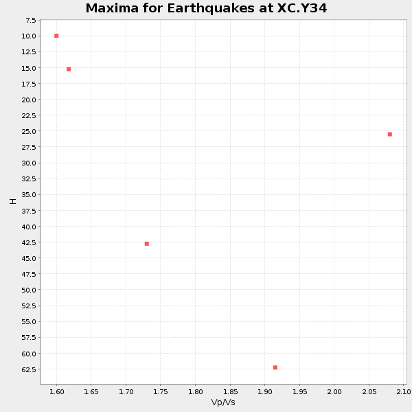
Plot maxima for each earthquake.
Events Used in the Stack
(5 events)| Radial Match | Distance | Baz | FERegion | Time | Lat/Lon | Depth | Magnitude |
| 88.269264 | 34.4 deg | 144.068 deg | El Salvador | 2001/01/13 17:33:32 GMT | (13.0, -88.7) | 60 km | 6.4 MB, 7.8 MS, 7.7 MW, 7.5 ME |
| 84.21527 | 50.9 deg | 114.541 deg | Windward Islands | 2000/10/04 14:37:44 GMT | (11.1, -62.6) | 110 km | 5.6 MB, 5.4 MS, 6.1 MW, 5.9 MD |
| 83.83144 | 43.3 deg | 140.749 deg | South Of Panama | 2000/12/12 05:26:45 GMT | (6.0, -82.7) | 10 km | 5.8 MB, 5.7 MS, 6.3 ME, 6.1 MW |
| 82.121574 | 44.9 deg | 134.016 deg | Panama-Colombia Border Region | 2000/11/08 06:59:58 GMT | (7.0, -77.8) | 17 km | 6.0 MB, 6.4 MS, 6.5 MW, 6.2 ML |
| 80.99696 | 33.7 deg | 144.012 deg | El Salvador | 2001/02/13 14:22:05 GMT | (13.7, -88.9) | 10 km | 5.5 MB, 6.5 MS, 6.6 MW, 6.1 MD |
Losers
(0 events)| Radial Match | Distance | Baz | FERegion | Time | Lat/Lon | Depth | Magnitude | Reason |
