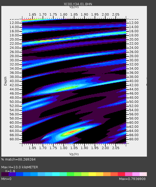
Y34 Y34 - Earthquake Result Viewer
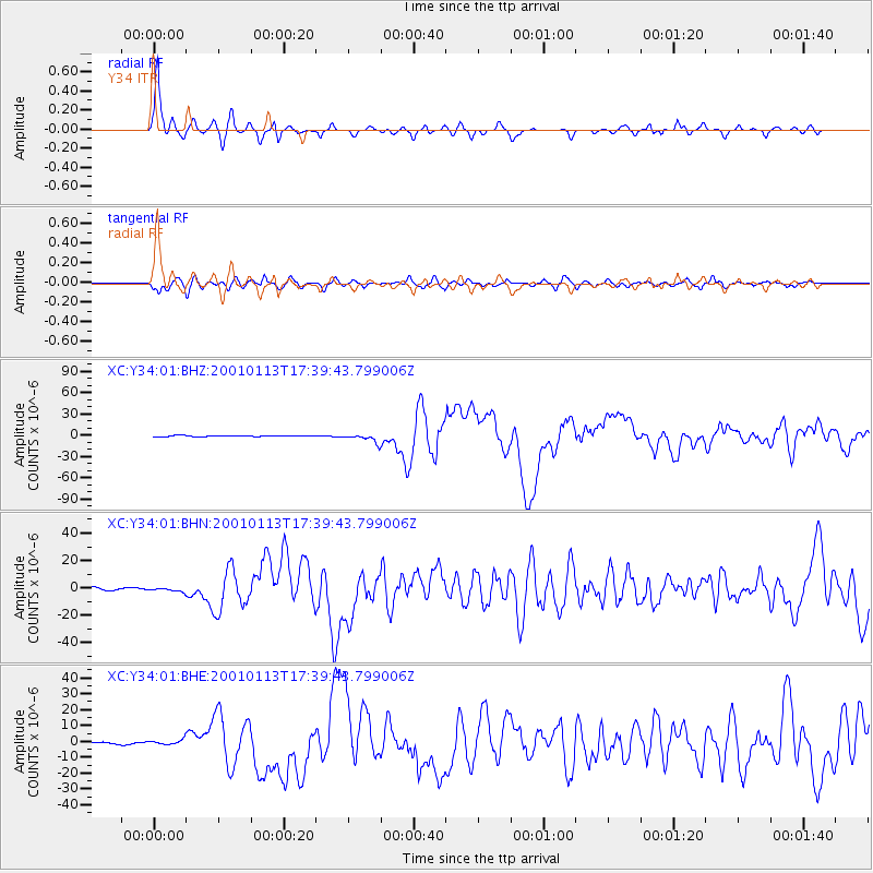
Earthquake location: El Salvador
Earthquake latitude/longitude: 13.0/-88.7
Earthquake time(UTC): 2001/01/13 (013) 17:33:32 GMT
Earthquake Depth: 60 km
Earthquake Magnitude: 6.4 MB, 7.8 MS, 7.7 MW, 7.5 ME
Earthquake Catalog/Contributor: WHDF/NEIC
Network: XC Yellowstone Intermountain Seismic Array
Station: Y34 Y34
Lat/Lon: 42.97 N/108.56 W
Elevation: 1562 m
Distance: 34.4 deg
Az: 333.77 deg
Baz: 144.068 deg
Ray Param: 0.07759099
Estimated Moho Depth: 10.0 km
Estimated Crust Vp/Vs: 1.60
Assumed Crust Vp: 6.161 km/s
Estimated Crust Vs: 3.851 km/s
Estimated Crust Poisson's Ratio: 0.18
Radial Match: 88.269264 %
Radial Bump: 307
Transverse Match: 64.763115 %
Transverse Bump: 400
SOD ConfigId: 16820
Insert Time: 2010-02-26 14:57:57.953 +0000
GWidth: 2.5
Max Bumps: 400
Tol: 0.001

Signal To Noise

ChannelStoNSTALTA
XC:Y34:01:BHN:20010113T17:39:43.799006Z1.64927761.4981621E-69.083747E-7
XC:Y34:01:BHE:20010113T17:39:43.799006Z2.59115821.7351849E-66.696561E-7
XC:Y34:01:BHZ:20010113T17:39:43.799006Z7.96610075.5418936E-66.956846E-7
Arrivals
Ps1.1 SECOND
PpPs3.9 SECOND
PsPs/PpSs5.0 SECOND